File:Plan for Michael attack, March 1918.jpg
From Wikimedia Commons, the free media repository
Jump to navigation
Jump to search
Size of this preview: 800 × 572 pixels. Other resolutions: 320 × 229 pixels | 640 × 457 pixels | 1,024 × 732 pixels | 1,280 × 914 pixels | 2,073 × 1,481 pixels.
Original file (2,073 × 1,481 pixels, file size: 492 KB, MIME type: image/jpeg)
File information
Structured data
Captions
This map image could be re-created using vector graphics as an SVG file. This has several advantages; see Commons:Media for cleanup for more information. If an SVG form of this image is available, please upload it and afterwards replace this template with
{{vector version available|new image name}} .
It is recommended to name the SVG file “Plan for Michael attack, March 1918.svg”—then the template Vector version available (or Vva) does not need the new image name parameter. |
This map image was uploaded in the JPEG format even though it consists of non-photographic data. This information could be stored more efficiently or accurately in the PNG or SVG format. If possible, please upload a PNG or SVG version of this image without compression artifacts, derived from a non-JPEG source (or with existing artifacts removed). After doing so, please tag the JPEG version with {{Superseded|NewImage.ext}} and remove this tag. This tag should not be applied to photographs or scans. If this image is a diagram or other image suitable for vectorisation, please tag this image with {{Convert to SVG}} instead of {{BadJPEG}}. If not suitable for vectorisation, use {{Convert to PNG}}. For more information, see {{BadJPEG}}. |
Summary
[edit]DescriptionPlan for Michael attack, March 1918.jpg |
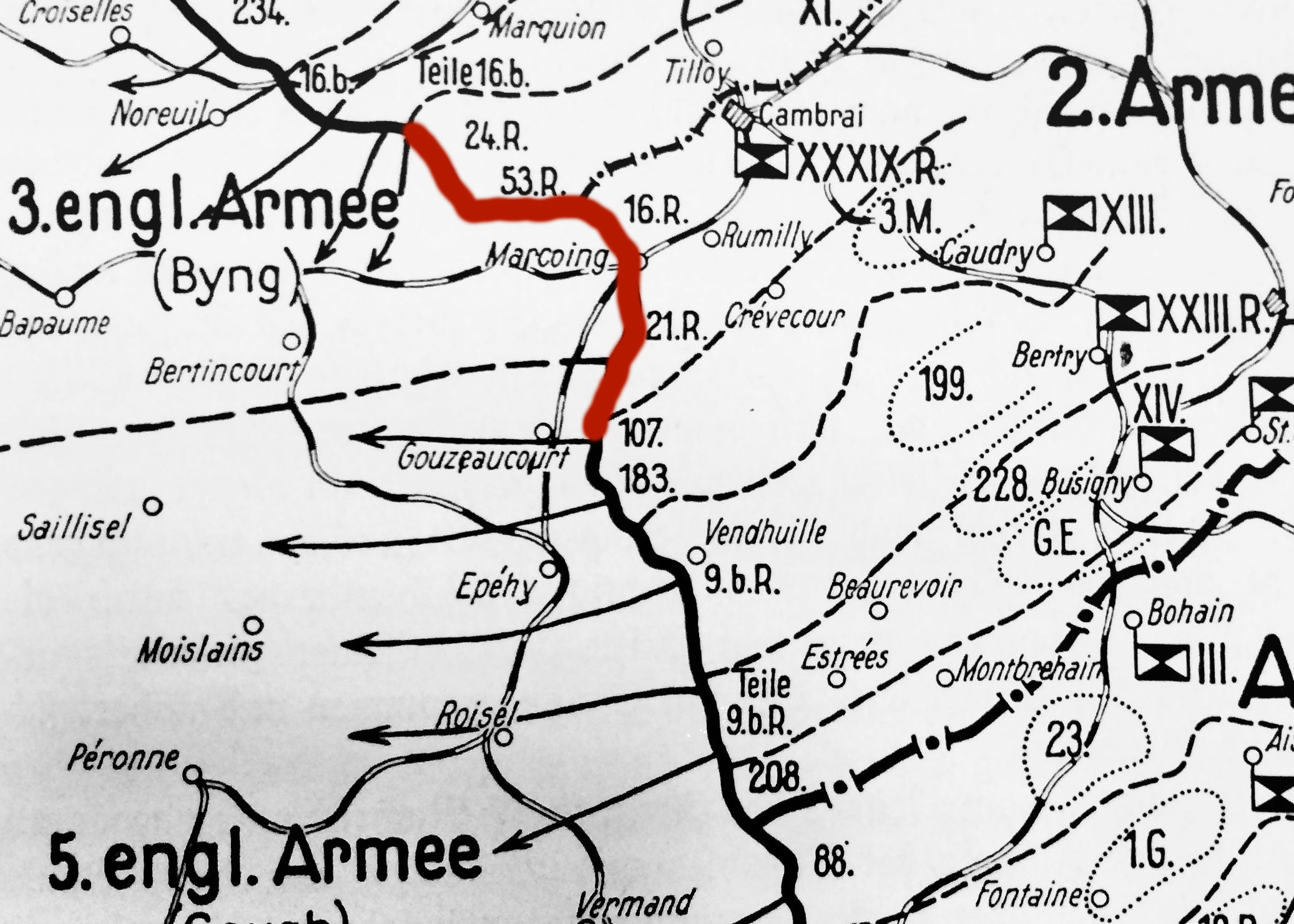
English: Map of the plan for the Michael attack of March 1919. The intent was to encircle the British V Corps by breaking though on either side of the front marked in red. |
Date | |
Source | Crown Prince Rupprecht's Kriegstagbuch, vol. 2., p. 347. Munich 1919, vol. 2, p.347 |
Author | Crown Prince Rupprecht of Bavaria |
Camera location | 51° 30′ 26.71″ N, 0° 08′ 11.42″ W | View this and other nearby images on: OpenStreetMap | 51.507419; -0.136506 |
---|
Licensing
[edit]Public domainPublic domainfalsefalse |
This work is in the public domain in the United States because it was published (or registered with the U.S. Copyright Office) before January 1, 1929.
Public domain works must be out of copyright in both the United States and in the source country of the work in order to be hosted on the Commons. If the work is not a U.S. work, the file must have an additional copyright tag indicating the copyright status in the source country.
Note: This tag should not be used for sound recordings.PD-1923Public domain in the United States//commons.wikimedia.org/wiki/File:Plan_for_Michael_attack,_March_1918.jpg |
File history
Click on a date/time to view the file as it appeared at that time.
Date/Time | Thumbnail | Dimensions | User | Comment | |
---|---|---|---|---|---|
current | 12:09, 11 March 2017 | 2,073 × 1,481 (492 KB) | Wkloot (talk | contribs) | User created page with UploadWizard |
You cannot overwrite this file.
File usage on Commons
There are no pages that use this file.
File usage on other wikis
The following other wikis use this file:
- Usage on de.wikipedia.org
- Usage on en.wikipedia.org
Metadata
This file contains additional information such as Exif metadata which may have been added by the digital camera, scanner, or software program used to create or digitize it. If the file has been modified from its original state, some details such as the timestamp may not fully reflect those of the original file. The timestamp is only as accurate as the clock in the camera, and it may be completely wrong.
Camera manufacturer | Apple |
---|---|
Camera model | iPhone 5s |
Date and time of data generation | 11:10, 10 March 2017 |
Exposure time | 1/33 sec (0.03030303030303) |
F-number | f/2.2 |
ISO speed rating | 40 |
Lens focal length | 4.15 mm |
Latitude | 51° 30′ 26.71″ N |
Longitude | 0° 8′ 11.42″ W |
Altitude | 15.237 meters above sea level |
Width | 2,073 px |
Height | 1,481 px |
Horizontal resolution | 72 dpi |
Vertical resolution | 72 dpi |
Orientation | Normal |
File change date and time | 11:46, 11 March 2017 |
Software used | PaintShop Pro 19.00 |
Exif version | 2.21 |
Supported Flashpix version | 1 |
Color space | sRGB |
Meaning of each component |
|
Date and time of digitizing | 11:10, 10 March 2017 |
DateTimeOriginal subseconds | 366 |
DateTimeDigitized subseconds | 366 |
Exposure Program | Normal program |
APEX shutter speed | 5.0594713656388 |
APEX aperture | 2.2750072066878 |
APEX brightness | 4.5859883521754 |
APEX exposure bias | 0 |
Metering mode | Pattern |
Flash | Flash did not fire, compulsory flash suppression |
Sensing method | One-chip color area sensor |
Scene type | A directly photographed image |
Exposure mode | Auto exposure |
White balance | Auto white balance |
Focal length in 35 mm film | 29 mm |
Scene capture type | Standard |
GPS time (atomic clock) | 11:10 |
Reference for direction of image | True direction |
Direction of image | 70.024680851064 |
GPS date | 2017 |