File:Plan des lignes de tramway dans la province d'Anvers 1950-01-01.jpg
Jump to navigation
Jump to search

Size of this preview: 579 × 600 pixels. Other resolutions: 232 × 240 pixels | 464 × 480 pixels | 742 × 768 pixels | 1,071 × 1,109 pixels.
Original file (1,071 × 1,109 pixels, file size: 607 KB, MIME type: image/jpeg)
Captions
Captions
Add a one-line explanation of what this file represents
Summary
[edit]| Title |
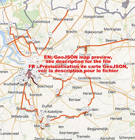
Français : Plan des lignes de tramway dans la province d'Anvers au 1er janvier 1950. |
|||||||||||||||||||||||||||||||||||||||||||||||||||||||||||||||
| Description |
 Français : Contenu et état d'avancement : incomplet
Éléments manquants ou à vérifier :
Parties communes avec d'autres cartes :
|
|||||||||||||||||||||||||||||||||||||||||||||||||||||||||||||||
| Source |
Own work Sources internes Sources cartographiques
|
|||||||||||||||||||||||||||||||||||||||||||||||||||||||||||||||
| Creator | ||||||||||||||||||||||||||||||||||||||||||||||||||||||||||||||||
| Georeferencing | If inappropriate please set warp_status = skip to hide. | |||||||||||||||||||||||||||||||||||||||||||||||||||||||||||||||
| Bibliographic data | ||||||||||||||||||||||||||||||||||||||||||||||||||||||||||||||||
| Language |
|
|||||||||||||||||||||||||||||||||||||||||||||||||||||||||||||||
| Archival data | ||||||||||||||||||||||||||||||||||||||||||||||||||||||||||||||||
| Notes |
Méthodologie : Notes méthodologiques
Organisation des données
Légende Générale pour les lignes de tramway et chemin de fer secondaireÉléments généraux de légende pour les cartes de tramway ou chemin de fer secondaire et explication de la nomenclature GEOjson :
Les cases marquées d'un point ne sont pas concernées.
Couleurs Les couleurs mixtes sont obtenues à parties de mélanges (en code HEX) sur geo-phile.net. |
|||||||||||||||||||||||||||||||||||||||||||||||||||||||||||||||


Licensing
[edit]
I, the copyright holder of this work, hereby publish it under the following license:
This file is licensed under the Creative Commons Attribution-Share Alike 4.0 International license.
- You are free:
- to share – to copy, distribute and transmit the work
- to remix – to adapt the work
- Under the following conditions:
- attribution – You must give appropriate credit, provide a link to the license, and indicate if changes were made. You may do so in any reasonable manner, but not in any way that suggests the licensor endorses you or your use.
- share alike – If you remix, transform, or build upon the material, you must distribute your contributions under the same or compatible license as the original.
File history
Click on a date/time to view the file as it appeared at that time.
| Date/Time | Thumbnail | Dimensions | User | Comment | |
|---|---|---|---|---|---|
| current | 13:58, 19 December 2020 | | 1,071 × 1,109 (607 KB) | Arflhn (talk | contribs) | Uploaded own work with UploadWizard |
You cannot overwrite this file.
File usage on Commons
The following page uses this file:
Metadata
Categories:
- Antwerp vicinal tram newtork
- Tram maps of Antwerp
- Tram route 41 (Antwerp)
- Tram route 42 (Antwerp)
- Tram route 52 (Antwerp)
- Tram route 61 (Antwerp)
- Tram route 64 (Antwerp)
- Tram route 65 (Antwerp)
- Tram route 72 (Antwerp)
- Tram route 75 (Antwerp)
- Tram route 77 (Antwerp)
- Tram route 1 (Antwerp, †1965)
- Tram route 2 (Antwerp)
- Tram route 3 (Antwerp)
- Tram route 53 (Antwerp)
- Tram route 54 (Antwerp)