File:Plan des fortifications de la Ville d'Huningue - btv1b8468433z.jpg
Jump to navigation
Jump to search

Size of this preview: 800 × 578 pixels. Other resolutions: 320 × 231 pixels | 640 × 462 pixels | 1,024 × 739 pixels | 1,280 × 924 pixels | 2,560 × 1,848 pixels | 7,210 × 5,205 pixels.
Original file (7,210 × 5,205 pixels, file size: 4.75 MB, MIME type: image/jpeg)
Captions
Captions
Add a one-line explanation of what this file represents
Summary
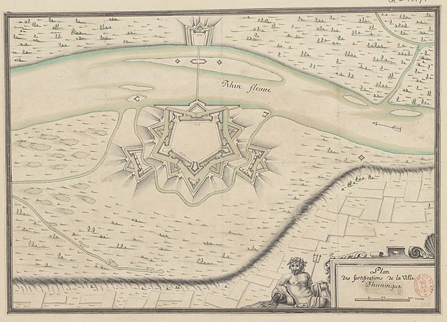
[edit]| Plan des fortifications de la Ville d'Huningue
( |
|||||||||||||||||||||||||||
|---|---|---|---|---|---|---|---|---|---|---|---|---|---|---|---|---|---|---|---|---|---|---|---|---|---|---|---|
| Title |
Plan des fortifications de la Ville d'Huningue |
||||||||||||||||||||||||||
| Description |
Français : Sujet : Fortifications
Plans de ville Huningue -- Fortifications Échelle(s) : 200 toises [=Om. 055 ; 1:3 500 ca] Appartient à l’ensemble documentaire : Alsace1 Couverture : France – Grand-Est – Haut-Rhin Langue : français Éditeur : [s.n.] |
||||||||||||||||||||||||||
| Date | 1690 | ||||||||||||||||||||||||||
| Collection |
|
||||||||||||||||||||||||||
| References |
Français : Notice du catalogue : http://catalogue.bnf.fr/ark:/12148/cb40620045w |
||||||||||||||||||||||||||
| Source/Photographer |
Français : Bibliothèque nationale de France, département Cartes et plans, GE D-10171
Bibliothèque nationale de France |
||||||||||||||||||||||||||
| Permission (Reusing this file) |
|
||||||||||||||||||||||||||

File history
Click on a date/time to view the file as it appeared at that time.
| Date/Time | Thumbnail | Dimensions | User | Comment | |
|---|---|---|---|---|---|
| current | 14:24, 20 August 2022 | | 7,210 × 5,205 (4.75 MB) | Gzen92Bot (talk | contribs) | Gallica btv1b8468433z |
You cannot overwrite this file.
File usage on Commons
The following page uses this file: