File:Plan de l'isthme de l'Acadie comprenant le Beau-Bassin avec une partie de la Baie Verte LOC 73696324.jpg
Jump to navigation
Jump to search

Size of this preview: 800 × 578 pixels. Other resolutions: 320 × 231 pixels | 640 × 462 pixels | 1,024 × 740 pixels | 1,280 × 925 pixels | 2,560 × 1,849 pixels | 7,565 × 5,464 pixels.
Original file (7,565 × 5,464 pixels, file size: 5.64 MB, MIME type: image/jpeg)
Captions
Captions
Add a one-line explanation of what this file represents
Summary
[edit]| Description |
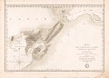
English: Relief shown by hachures. Depths shown by soundings. "Longitude occidentale du meridien de Paris." "No. 1. D." located above upper right corner of border. From the author's Neptune Americo-Septentrional contenant les côtes. 1778-80. LC Maps of North America, 1750-1789, 402 Available also through the Library of Congress Web site as a raster image. Vault AACR2: 100; 651/1; 700/1 |
||
| Title | Plan de l'isthme de l'Acadie comprenant le Beau-Bassin avec une partie de la Baie Verte | ||
| Shelf ID | G3422.C45 1779 .F7 | ||
| Date | |||
| Source | https://www.loc.gov/item/73696324/ | ||
| Author | France. Dépôt Des Cartes Et Plans De La Marine; Sartine, Antoine De; Petit | ||
| Permission (Reusing this file) |
|
||
| Other versions |
|
||
| Location | Canada · Chignecto Isthmus. · Nova Scotia · New Brunswick · Chignecto Isthmus | ||
| Part of | Military Battles And Campaigns · American Memory · Catalog · Geography And Map Division | ||
| Subject | Canada · Chignecto Isthmus (N. And N.S.) · Chignecto Isthmus · Early Maps · Maps · Early Works To 1800 · Nova Scotia · New Brunswick |

Licensing
[edit]
|
This is a faithful photographic reproduction of a two-dimensional, public domain work of art. The work of art itself is in the public domain for the following reason:
The official position taken by the Wikimedia Foundation is that "faithful reproductions of two-dimensional public domain works of art are public domain".
This photographic reproduction is therefore also considered to be in the public domain in the United States. In other jurisdictions, re-use of this content may be restricted; see Reuse of PD-Art photographs for details. | ||||
File history
Click on a date/time to view the file as it appeared at that time.
| Date/Time | Thumbnail | Dimensions | User | Comment | |
|---|---|---|---|---|---|
| current | 17:28, 18 May 2018 | | 7,565 × 5,464 (5.64 MB) | Fæ (talk | contribs) | LOC Maps https://www.loc.gov/item/73696324/ #10901 |
You cannot overwrite this file.
File usage on Commons
The following page uses this file: