File:Plan de Jérusalem. R. Hausermann, Carte de la Terre Sainte (FL6881904 2367015) (cropped).jpg
Jump to navigation
Jump to search

Size of this preview: 541 × 600 pixels. Other resolutions: 216 × 240 pixels | 433 × 480 pixels | 693 × 768 pixels | 923 × 1,024 pixels | 1,847 × 2,048 pixels | 3,620 × 4,014 pixels.
Original file (3,620 × 4,014 pixels, file size: 20.22 MB, MIME type: image/jpeg)
Captions
Captions
Add a one-line explanation of what this file represents
Summary
[edit]| Carte de la Terre Sainte
|
|||||||||||||||||||||||||||||||||||||||||||
|---|---|---|---|---|---|---|---|---|---|---|---|---|---|---|---|---|---|---|---|---|---|---|---|---|---|---|---|---|---|---|---|---|---|---|---|---|---|---|---|---|---|---|---|
| Artist |
|
.jpg) | |||||||||||||||||||||||||||||||||||||||||
| Title |
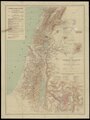
Plan de Jérusalem |
||||||||||||||||||||||||||||||||||||||||||
| Publisher | |||||||||||||||||||||||||||||||||||||||||||
| Object type |
topographic map |
||||||||||||||||||||||||||||||||||||||||||
| Genre |
map |
||||||||||||||||||||||||||||||||||||||||||
| Description |
Carte de la Terre Sainte. Palestine moderne . Dessinee d'apres: la Palestine Fund, les cartes de I'Etat Major Francais, de V.Guerin, de A.Legendre, du P.H.Vincent, du Guide de Terre Sainte du P.Barnabe, et les Documents les plus recents. |
||||||||||||||||||||||||||||||||||||||||||
| Language |
English |
||||||||||||||||||||||||||||||||||||||||||
| Publication date |
1914 |
||||||||||||||||||||||||||||||||||||||||||
| Collection |
|
||||||||||||||||||||||||||||||||||||||||||
| Current location |
|
||||||||||||||||||||||||||||||||||||||||||
| Place of publication |
Paris |
||||||||||||||||||||||||||||||||||||||||||
| Notes | Inset map Plan de Jerusalem; Includes list of Catholic establishments. | ||||||||||||||||||||||||||||||||||||||||||
| IE PID | IE6881902 | ||||||||||||||||||||||||||||||||||||||||||
| Rosetta filename | FL6881904 | ||||||||||||||||||||||||||||||||||||||||||
| NNL item ID (P3959) | 990023670150205171 | ||||||||||||||||||||||||||||||||||||||||||
| search Merhav catalog | English, Rémy Hausermann, Paris, Imprimerie Gaillac-Monrocq, Jerusalem | ||||||||||||||||||||||||||||||||||||||||||
| search Merhav catalog | CatholicsIsraelImp. Gaillac-Monrocq et Cie | ||||||||||||||||||||||||||||||||||||||||||
| Source/Photographer |
|
||||||||||||||||||||||||||||||||||||||||||
| Other versions | |||||||||||||||||||||||||||||||||||||||||||
| Jpg / Tif version |
|
||||||||||||||||||||||||||||||||||||||||||


_(cropped).jpg&action=edit§ion=1)
Licensing
[edit]_(cropped).jpg&action=edit§ion=2)
The copyright situation of this work is theoretically uncertain, because in the country of origin copyright lasts 70 years after the death of the author, and the date of the author's death is unknown. However, the date of creation of the work was over 120 years ago, and it is thus a reasonable assumption that the copyright has expired (see here for the community discussion). Do not use this template if the date of death of the author is known.
| |
| This file has been identified as being free of known restrictions under copyright law, including all related and neighboring rights. | |
File history
Click on a date/time to view the file as it appeared at that time.
| Date/Time | Thumbnail | Dimensions | User | Comment | |
|---|---|---|---|---|---|
| current | 19:37, 27 July 2023 | | 3,620 × 4,014 (20.22 MB) | Geagea (talk | contribs) | File:R. Hausermann, Carte de la Terre Sainte (FL6881904 2367015).jpg cropped 60 % horizontally, 67 % vertically using CropTool with precise mode. |
You cannot overwrite this file.
File usage on Commons
The following 2 pages use this file:
_(cropped).jpg)
_(cropped).jpg&oldid=789199954)