File:Plan annexe a un contrat notarie - Henry Hiche 1734.jpg
Jump to navigation
Jump to search

No higher resolution available.
Plan_annexe_a_un_contrat_notarie_-_Henry_Hiche_1734.jpg (700 × 372 pixels, file size: 49 KB, MIME type: image/jpeg)
Captions
Captions
Add a one-line explanation of what this file represents
Summary
[edit]
| Description |
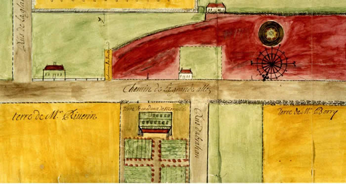
Français : Plan annexé à un contrat notarié « Ce plan de 1734 porte la première mention localisée avec précision du toponyme Abraham. La «rue d’Abraham» rejoint le Chemin de la Grande Allée, mais sans prolongement au sud, site actuel des plaines d’Abraham. » – ccbn-nbc.gc.ca |
| Date | |
| Source | * - ccbn-nbc.gc.ca - facebook.com |
| Author | Henry Hiché |
Licensing
[edit]
|
This work is in the public domain in its country of origin and other countries and areas where the copyright term is the author's life plus 70 years or fewer. This work is in the public domain in the United States because it was published (or registered with the U.S. Copyright Office) before January 1, 1929. | |
| This file has been identified as being free of known restrictions under copyright law, including all related and neighboring rights. | |
File history
Click on a date/time to view the file as it appeared at that time.
| Date/Time | Thumbnail | Dimensions | User | Comment | |
|---|---|---|---|---|---|
| current | 21:56, 16 November 2016 | | 700 × 372 (49 KB) | Jeangagnon (talk | contribs) | User created page with UploadWizard |
You cannot overwrite this file.
File usage on Commons
There are no pages that use this file.