File:Plan - Canton de Chambéry-Nord-Sonnaz (2015).png
Jump to navigation
Jump to search

Size of this preview: 383 × 600 pixels. Other resolutions: 153 × 240 pixels | 306 × 480 pixels | 490 × 768 pixels | 654 × 1,024 pixels | 1,316 × 2,060 pixels.
Original file (1,316 × 2,060 pixels, file size: 2.4 MB, MIME type: image/png)
Captions
Captions
Add a one-line explanation of what this file represents
Summary
[edit].png&action=edit§ion=1)
| Description | ||||
| Date | ||||
| Source | Own work | |||
| Author |
Open Street Map contributors / Florian Pépellin for the boundaries Contributeurs à Open Street Map / Florian Pépellin pour les limites |
|||
| Permission (Reusing this file) |
OpenStreetMap data is available under the Open Database License (details). Map tiles are licensed under the Creative Commons Attribution-ShareAlike 2.0 license (CC-BY-SA 2.0).
|
File history
Click on a date/time to view the file as it appeared at that time.
| Date/Time | Thumbnail | Dimensions | User | Comment | |
|---|---|---|---|---|---|
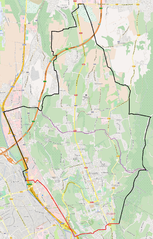
| current | 15:13, 27 March 2015 | | 1,316 × 2,060 (2.4 MB) | Floflo (talk | contribs) | {{Information |Description ={{en|1=Map of the ''canton de Chambéry-Nord/Sonnaz'', former territorial subdivision of Chambéry and ''Sonnaz'' (Savoie, France), serving as constituency for the election of the ''Conseil général de la Sav... |
You cannot overwrite this file.
File usage on Commons
There are no pages that use this file.
File usage on other wikis
The following other wikis use this file:
- Usage on ca.wikipedia.org
- Usage on es.wikipedia.org
- Usage on fr.wikipedia.org
- Usage on www.wikidata.org
.png&oldid=425243094)