File:Plan-relief Palais des Beaux Arts Lille Dec 2018 Pierreazertyuiop.jpg
Jump to navigation
Jump to search

Size of this preview: 800 × 600 pixels. Other resolutions: 320 × 240 pixels | 640 × 480 pixels | 1,024 × 768 pixels | 1,280 × 960 pixels | 2,560 × 1,920 pixels | 4,608 × 3,456 pixels.
Original file (4,608 × 3,456 pixels, file size: 3.18 MB, MIME type: image/jpeg)
Captions
Captions
Add a one-line explanation of what this file represents
Summary
[edit]
| Description |
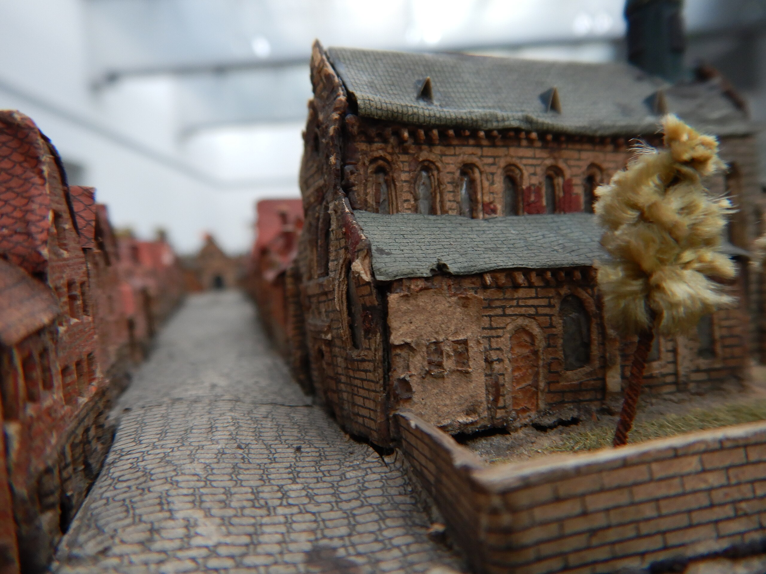
Français : Plan-relief de Tournai, commandé par Louis XIV, conservé et exposé au Palais des Beaux Arts de Lille, en cours de restauration (décembre 2018). Vue depuis une rue pavée, de l'intérieur d'une ville fortifiée, à l'époque de Louis XIV, avec au premier plan à droite un muret, un petite zone engazonnée, avec un arbre, devant une église de style roman, avec toit en ardoise; La photo présente la rue en enfilade, avec maisons de briques et toits de tuiles rouges des deux côtés. Rem : de la peinture rouge brique unie a été apposée sur une partie du mur. Cette même peinture est trouvée sur d'autres bâtiments, toujours ne couvrant qu'une petite partie du mur. On ignore encore sa signification. On distingue en haut de la photographie le toit de la salle de restauration (fait de dalles de verre, laissant passer la lumière, qui peut être plus ou moins tamisée par un système de stores contrôlables à distance).
English: "Plan-relief", commissioned by Louis XIV, preserved and exhibited in the "Palais des Beaux Arts" in Lille, under restoration (December 2018). View from a paved street, from the inside of a walled city, at the time of Louis XIV, with in the foreground on the right a wall, a small grassed area, with a tree, in front of a Romanesque church, with slate roof; The photo shows the street in a row. with brick houses and red tile roofs on both sides. the top of this museum's room is covered with glass slabs, letting the light through. Note: some brick red paint has been applied to a part of the church's wall. This same painting is found on other buildings, still covering only a small part of the wall. We still do not know its meaning |
| Date | |
| Source | Own work |
| Author | Pierreazertyuiop |
| Camera location | | View this and other nearby images on: OpenStreetMap |
|---|
Suggestion : rechercher dans tournai si cette rue existe encore et prendre une photo
Licensing
[edit]
I, the copyright holder of this work, hereby publish it under the following license:
This file is licensed under the Creative Commons Attribution-Share Alike 4.0 International license.
- You are free:
- to share – to copy, distribute and transmit the work
- to remix – to adapt the work
- Under the following conditions:
- attribution – You must give appropriate credit, provide a link to the license, and indicate if changes were made. You may do so in any reasonable manner, but not in any way that suggests the licensor endorses you or your use.
- share alike – If you remix, transform, or build upon the material, you must distribute your contributions under the same or compatible license as the original.
File history
Click on a date/time to view the file as it appeared at that time.
| Date/Time | Thumbnail | Dimensions | User | Comment | |
|---|---|---|---|---|---|
| current | 15:32, 21 December 2018 | | 4,608 × 3,456 (3.18 MB) | Embedded Data Bot (talk | contribs) | This file contains embedded data: After 3.2MiB (3339326 bytes, via Ending): Identified type: image/jpeg (JPEG image data, Exif standard: [TIFF image data, little-endian, direntries=1], baseline, precision 8, 640x480, frames 3) |
| 15:32, 21 December 2018 |  | 4,608 × 3,456 (3.55 MB) | Pierreazertyuiop (talk | contribs) | User created page with UploadWizard |
You cannot overwrite this file.
File usage on Commons
There are no pages that use this file.
File usage on other wikis
The following other wikis use this file:
- Usage on fr.wikipedia.org
- Usage on oc.wikipedia.org