File:Plan, Lake Champlain from Fort St. John's to Ticonderoga, with the soundings, rocks, shoals, and sands, surveyed in the years 1778, 1779. LOC gm71000657.jpg
Jump to navigation
Jump to search

Size of this preview: 800 × 268 pixels. Other resolutions: 320 × 107 pixels | 640 × 215 pixels | 1,024 × 343 pixels | 1,280 × 429 pixels | 2,560 × 858 pixels | 30,000 × 10,057 pixels.
Original file (30,000 × 10,057 pixels, file size: 27.81 MB, MIME type: image/jpeg)
Captions
Captions
Add a one-line explanation of what this file represents
Summary
[edit]| Warning | The original file is very high-resolution. It might not load properly or could cause your browser to freeze when opened at full size. |
|---|
| Description |
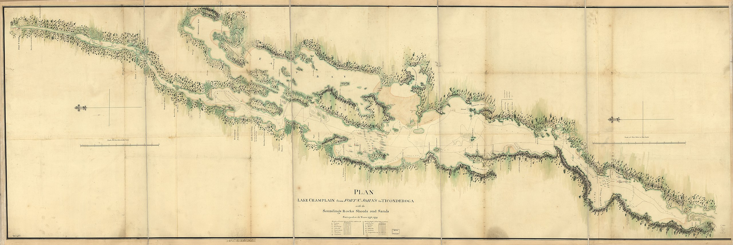
English: Scale 1:63,360; 1 mile to 1 in. Manuscript, pen-and-ink and watercolor. Oriented with north to the left. Shows ships present at the Battle of Valcour Island, Oct. 11, 1776 and a running fight at Buttonmold Bay, Oct., 13, 1776. LC Maps of North America, 1750-1789, 1176 Available also through the Library of Congress Web site as a raster image. Vault AACR2: 651/1; 650/2 |
||
| Title | Plan, Lake Champlain from Fort St. John's to Ticonderoga, with the soundings, rocks, shoals, and sands, surveyed in the years 1778, 1779. | ||
| Shelf ID | G3802.C45 1779 .P5 | ||
| Date | |||
| Source | https://www.loc.gov/item/gm71000657/ | ||
| Author | Unknown author | ||
| Permission (Reusing this file) |
|
||
| Other versions |
|
||
| Location | Canada · Champlain · Vermont · Champlain, Lake · Valcour Island · Lake · United States · Québec · New York · New York (State) · Québec (Province) | ||
| Part of | Military Battles And Campaigns · American Memory · Catalog · Geography And Map Division · American Revolution And Its Era: Maps And Charts Of North America And The West Indies, 1750-1789 | ||
| Subject | Canada · Maps, Manuscript · Vermont · Champlain, Lake · Valcour Island · Valcour Island, Battle Of, N.Y. · Early Works To 1800 · New York (State) · Québec (Province) · United States |

Licensing
[edit]
|
This is a faithful photographic reproduction of a two-dimensional, public domain work of art. The work of art itself is in the public domain for the following reason:
The official position taken by the Wikimedia Foundation is that "faithful reproductions of two-dimensional public domain works of art are public domain".
This photographic reproduction is therefore also considered to be in the public domain in the United States. In other jurisdictions, re-use of this content may be restricted; see Reuse of PD-Art photographs for details. | ||||
File history
Click on a date/time to view the file as it appeared at that time.
| Date/Time | Thumbnail | Dimensions | User | Comment | |
|---|---|---|---|---|---|
| current | 09:07, 4 June 2018 | 30,000 × 10,057 (27.81 MB) | Fæ (talk | contribs) | LOC Maps https://www.loc.gov/item/gm71000657/ #4411 |
You cannot overwrite this file.
File usage on Commons
The following page uses this file: