File:Pitcairn Island Group.svg
From Wikimedia Commons, the free media repository
Jump to navigation
Jump to search

Size of this PNG preview of this SVG file: 500 × 495 pixels. Other resolutions: 242 × 240 pixels | 485 × 480 pixels | 776 × 768 pixels | 1,034 × 1,024 pixels | 2,069 × 2,048 pixels.
Original file (SVG file, nominally 500 × 495 pixels, file size: 48 KB)
File information
Structured data
Captions
Captions
Add a one-line explanation of what this file represents
Summary
[edit]| DescriptionPitcairn Island Group.svg |
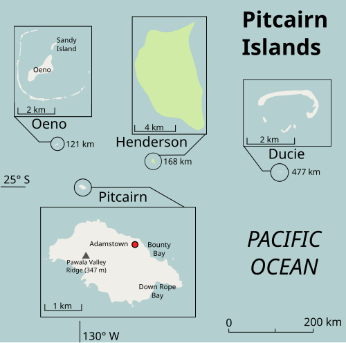
Deutsch: Karte der Pitcairninseln im Südpazifik
English: A SVG map of the Pitcairn Island group, heavily inspired by an earlier work of Andrew J. Kurbiko, User Albinfo and using Openstreetmap.org data. Derived from the work of Andrew J. Kurbiko, Albinfo and the Openstreetmap.org contributors |
| Date | |
| Source | Own work |
| Author |
|
Licensing
[edit]I, the copyright holder of this work, hereby publish it under the following license:
This file is licensed under the Creative Commons Attribution-Share Alike 3.0 Unported license.
- You are free:
- to share – to copy, distribute and transmit the work
- to remix – to adapt the work
- Under the following conditions:
- attribution – You must give appropriate credit, provide a link to the license, and indicate if changes were made. You may do so in any reasonable manner, but not in any way that suggests the licensor endorses you or your use.
- share alike – If you remix, transform, or build upon the material, you must distribute your contributions under the same or compatible license as the original.
File history
Click on a date/time to view the file as it appeared at that time.
| Date/Time | Thumbnail | Dimensions | User | Comment | |
|---|---|---|---|---|---|
| current | 15:41, 5 April 2012 |  | 500 × 495 (48 KB) | Hansbaer (talk | contribs) | Small change (name of Ducie island was missing) |
| 12:18, 5 April 2012 |  | 500 × 495 (54 KB) | Lencer (talk | contribs) | vllt. so? | |
| 06:48, 31 March 2012 |  | 817 × 503 (1.18 MB) | Hansbaer (talk | contribs) | Just to test if this one works better. | |
| 10:37, 10 March 2012 |  | 817 × 503 (1.12 MB) | Hansbaer (talk | contribs) |
You cannot overwrite this file.
File usage on Commons
The following 12 pages use this file:
- File:United Kingdom (overseas+crown dependencies), administrative divisions - Nmbrs (marker).svg
- File:United Kingdom (overseas+crown dependencies), administrative divisions - Nmbrs (multiple zoom).svg
- File:United Kingdom (overseas+crown dependencies), administrative divisions - Nmbrs (single zoom).svg
- File:United Kingdom (overseas+crown dependencies), administrative divisions - de (marker).svg
- File:United Kingdom (overseas+crown dependencies), administrative divisions - de (multiple zoom).svg
- File:United Kingdom (overseas+crown dependencies), administrative divisions - de (single zoom).svg
- File:United Kingdom (overseas-crown dependencies), administrative divisions - Nmbrs (marker).svg
- File:United Kingdom (overseas-crown dependencies), administrative divisions - Nmbrs (multiple zoom).svg
- File:United Kingdom (overseas-crown dependencies), administrative divisions - Nmbrs (single zoom).svg
- File:United Kingdom (overseas-crown dependencies), administrative divisions - de (marker).svg
- File:United Kingdom (overseas-crown dependencies), administrative divisions - de (multiple zoom).svg
- File:United Kingdom (overseas-crown dependencies), administrative divisions - de (single zoom).svg
File usage on other wikis
The following other wikis use this file:
- Usage on bn.wikipedia.org
- Usage on ce.wikipedia.org
- Usage on de.wikipedia.org
- Usage on en.wikipedia.org
- Usage on en.wikibooks.org
- Usage on frr.wikipedia.org
- Usage on gl.wikipedia.org
- Usage on id.wikipedia.org
- Usage on ru.wikipedia.org
- Usage on sl.wikipedia.org
- Usage on sr.wikipedia.org
- Usage on tg.wikipedia.org
- Usage on to.wikipedia.org
- Usage on tr.wikipedia.org
- Usage on vi.wikipedia.org
Structured data
Items portrayed in this file
depicts
10 March 2012
48,743 byte
495 pixel
500 pixel
image/svg+xml
3e7014a96f11701e04be9f325f6f7754ac90d8d9
Hidden categories: