File:PitRiverMap.jpg
Jump to navigation
Jump to search
Size of this preview: 654 × 599 pixels. Other resolutions: 262 × 240 pixels | 524 × 480 pixels | 683 × 626 pixels.
Original file (683 × 626 pixels, file size: 295 KB, MIME type: image/jpeg)
Captions
Captions
Add a one-line explanation of what this file represents
Summary
[edit]
| Description |
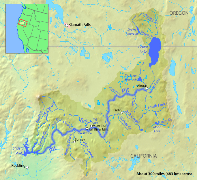
English: Map of the Pit River course and watershed in northeastern California.
|
| Date | |
| Source | Background from http://www2.demis.nl/mapserver/mapper.asp |
| Author | Background layer attributed to DEMIS Mapserver, modified by Shannon1 |
| Permission (Reusing this file) |
Map created from DEMIS Mapserver, which are public domain. |
Licensing
[edit]
I, the copyright holder of this work, hereby publish it under the following licenses:

|
Permission is granted to copy, distribute and/or modify this document under the terms of the GNU Free Documentation License, Version 1.2 or any later version published by the Free Software Foundation; with no Invariant Sections, no Front-Cover Texts, and no Back-Cover Texts. A copy of the license is included in the section entitled GNU Free Documentation License. |
This file is licensed under the Creative Commons Attribution-Share Alike Attribution-Share Alike 4.0 International, 3.0 Unported, 2.5 Generic, 2.0 Generic and 1.0 Generic license.
- You are free:
- to share – to copy, distribute and transmit the work
- to remix – to adapt the work
- Under the following conditions:
- attribution – You must give appropriate credit, provide a link to the license, and indicate if changes were made. You may do so in any reasonable manner, but not in any way that suggests the licensor endorses you or your use.
- share alike – If you remix, transform, or build upon the material, you must distribute your contributions under the same or compatible license as the original.
You may select the license of your choice.
File history
Click on a date/time to view the file as it appeared at that time.
| Date/Time | Thumbnail | Dimensions | User | Comment | |
|---|---|---|---|---|---|
| current | 23:22, 18 December 2010 | | 683 × 626 (295 KB) | Shannon1 (talk | contribs) | adjusted watershed boundary, stream names, location map, other minor changes |
| 00:41, 30 January 2010 |  | 1,119 × 794 (394 KB) | Shannon1 (talk | contribs) | added labels for Fall River Mills, Bieber, and Alturas | |
| 00:33, 30 January 2010 |  | 1,117 × 800 (391 KB) | Shannon1 (talk | contribs) | {{Information |Description={{en|1=Map of the Pit River watershed in northern CA}} |Source=Background from http://www2.demis.nl/mapserver/mapper.asp |Author=Background layer attributed to DEMIS Mapserver, modified by Shannon1 |Date=2010-01-29 |Permission= |
You cannot overwrite this file.
File usage on Commons
There are no pages that use this file.
File usage on other wikis
The following other wikis use this file:
Metadata
Categories:
- Pit River (California)
- Maps of rivers in California
- Maps of Modoc County, California
- Maps of Lassen County, California
- Maps of Shasta-Trinity National Forest
- Burney, California
- Maps of Klamath County, Oregon
- Klamath Falls, Oregon
- Fall River Mills, California
- Adin, California
- Shasta Lake
- Hat Creek (California)
- Goose Lake Valley