File:Pinus cembroides range map.png
Jump to navigation
Jump to search

Size of this preview: 750 × 600 pixels. Other resolutions: 300 × 240 pixels | 600 × 480 pixels | 1,000 × 800 pixels.
Original file (1,000 × 800 pixels, file size: 28 KB, MIME type: image/png)
Captions
Captions
Add a one-line explanation of what this file represents
Summary
[edit]
| Description |
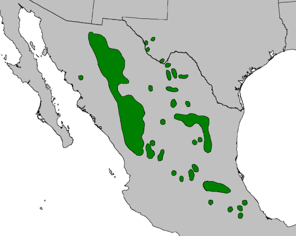
English: Range map of Pinus cembroides. |
| Date | |
| Source | Adapted from Digital representation of "Atlas of United States Trees" by Elbert L. Little, Jr. [1], with taxonomic update to remove Pinus remota and Pinus johannis |
| Author | U.S. Geological Survey |
| Other versions | File:Pinus cembroides range map.jpg (jpeg version) |
Licensing
[edit]
This image is in the public domain in the United States because it only contains materials that originally came from the United States Geological Survey, an agency of the United States Department of the Interior. For more information, see the official USGS copyright policy.
|
File history
Click on a date/time to view the file as it appeared at that time.
| Date/Time | Thumbnail | Dimensions | User | Comment | |
|---|---|---|---|---|---|
| current | 23:44, 10 October 2023 | | 1,000 × 800 (28 KB) | MPF (talk | contribs) | update to remove species split Pinus lagunae (Baja Cal Sur); crop to fit better |
| 10:53, 23 September 2013 |  | 1,003 × 1,160 (22 KB) | MPF (talk | contribs) | {{Information |Description={{en|Range map of ''Pinus cembroides''.}} |Source=Adapted from ''Digital representation of "Atlas of United States Trees"'' by Elbert L. Little, Jr. [http://esp.cr.usgs.gov/data/atlas/little/], with taxonomic update to remove... |
You cannot overwrite this file.
File usage on Commons
The following 2 pages use this file:
File usage on other wikis
The following other wikis use this file:
- Usage on ceb.wikipedia.org
- Usage on cs.wikipedia.org
- Usage on de.wikipedia.org
- Usage on en.wikipedia.org
- Usage on es.wikipedia.org
- Usage on fi.wikipedia.org
- Usage on fr.wikipedia.org
- Usage on is.wikipedia.org
- Usage on lt.wikipedia.org
- Usage on pl.wikipedia.org
- Usage on pt.wikipedia.org
- Usage on species.wikimedia.org
- Usage on sv.wikipedia.org
- Usage on uk.wikipedia.org
- Usage on www.wikidata.org