File:Pilot chart of the North Atlantic LOC 2009575936.jpg
Jump to navigation
Jump to search

Size of this preview: 426 × 599 pixels. Other resolutions: 170 × 240 pixels | 341 × 480 pixels | 546 × 768 pixels | 728 × 1,024 pixels | 1,456 × 2,048 pixels | 7,548 × 10,618 pixels.
Original file (7,548 × 10,618 pixels, file size: 9.7 MB, MIME type: image/jpeg)
Captions
Captions
Add a one-line explanation of what this file represents
Summary
[edit]| Warning | The original file is very high-resolution. It might not load properly or could cause your browser to freeze when opened at full size. |
|---|
| Description |
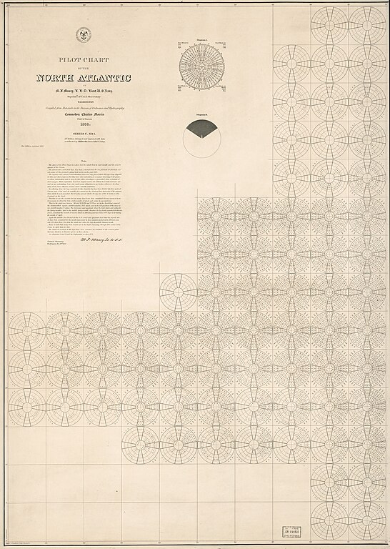
English: Shows prevailing wind direction by month. "Series C. No. 1." "New edition corrected 1857." The pilot charts were released as series C a part of Maury's "Wind and current charts", series A-F. These charts were designed for sailing ships and recorded wind direction observations made by mariners on previous voyages. For complete discussion, see "The wind and current chart series produced by Matthew Fontaine Maury," by Marc I. Pinsel, in Navigation : Journal of the Institute of Navigation, v. 28, no. 2 (Summer, 1981), p. 123-137. Includes diagrams and notes in map area with signature of M.F. Maury. In upper left margin: 9. Available also through the Library of Congress Web site as a raster image. |
||
| Title | Pilot chart of the North Atlantic | ||
| Shelf ID | G9111.P5 1853 .M2 | ||
| Date | |||
| Source | https://www.loc.gov/item/2009575936/ | ||
| Author | Maury, Matthew Fontaine; Brooke, John M. (John Mercer); United States. Bureau Of Ordnance And Hydrography; United States. Hydrographic Office; United States Naval Observatory | ||
| Permission (Reusing this file) |
|
||
| Other versions |
|
||
| Location | North Atlantic Ocean · North Atlantic Ocean. | ||
| Part of | American Memory · General Maps · Catalog · Geography And Map Division | ||
| Subject | Winds · North Atlantic Ocean · Nautical Charts · Maps |


Licensing
[edit]
|
This is a faithful photographic reproduction of a two-dimensional, public domain work of art. The work of art itself is in the public domain for the following reason:
The official position taken by the Wikimedia Foundation is that "faithful reproductions of two-dimensional public domain works of art are public domain".
This photographic reproduction is therefore also considered to be in the public domain in the United States. In other jurisdictions, re-use of this content may be restricted; see Reuse of PD-Art photographs for details. | ||||
File history
Click on a date/time to view the file as it appeared at that time.
| Date/Time | Thumbnail | Dimensions | User | Comment | |
|---|---|---|---|---|---|
| current | 12:57, 9 June 2018 | | 7,548 × 10,618 (9.7 MB) | Fæ (talk | contribs) | LOC Maps https://www.loc.gov/item/2009575936/ #9663 |
You cannot overwrite this file.
File usage on Commons
The following page uses this file: