File:Pilot Rock Panorama from West Edge.jpg
Jump to navigation
Jump to search

Size of this preview: 799 × 117 pixels. Other resolutions: 320 × 47 pixels | 640 × 94 pixels | 1,024 × 150 pixels | 1,280 × 187 pixels | 2,560 × 375 pixels | 19,737 × 2,891 pixels.
Original file (19,737 × 2,891 pixels, file size: 7 MB, MIME type: image/jpeg)
Captions
Captions
Add a one-line explanation of what this file represents
| Warning | The original file is very high-resolution. It might not load properly or could cause your browser to freeze when opened at full size. |
|---|
Summary
[edit]
| 360° | View in 360° panoramic viewer
|
|---|
| Description |
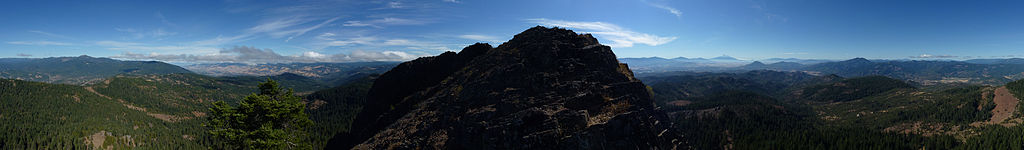
English: 360-degree panorama from the western edge of Pilot Rock. |
| Date | |
| Source | Own work |
| Author | Little Mountain 5 |
| Camera location | | View this and other nearby images on: OpenStreetMap |
|---|
Licensing
[edit]
I, the copyright holder of this work, hereby publish it under the following license:
This file is licensed under the Creative Commons Attribution-Share Alike 3.0 Unported license.
- You are free:
- to share – to copy, distribute and transmit the work
- to remix – to adapt the work
- Under the following conditions:
- attribution – You must give appropriate credit, provide a link to the license, and indicate if changes were made. You may do so in any reasonable manner, but not in any way that suggests the licensor endorses you or your use.
- share alike – If you remix, transform, or build upon the material, you must distribute your contributions under the same or compatible license as the original.
| Annotations | This image is annotated: View the annotations at Commons |
File history
Click on a date/time to view the file as it appeared at that time.
| Date/Time | Thumbnail | Dimensions | User | Comment | |
|---|---|---|---|---|---|
| current | 01:38, 7 September 2013 | 19,737 × 2,891 (7 MB) | Little Mountain 5 (talk | contribs) | User created page with UploadWizard |
You cannot overwrite this file.
File usage on Commons
There are no pages that use this file.
File usage on other wikis
The following other wikis use this file:
- Usage on en.wikipedia.org