File:Pill Box - geograph.org.uk - 1715825.jpg
Jump to navigation
Jump to search

Size of this preview: 800 × 506 pixels. Other resolutions: 320 × 202 pixels | 640 × 405 pixels | 1,024 × 648 pixels | 1,280 × 809 pixels | 2,560 × 1,619 pixels | 3,990 × 2,523 pixels.
Original file (3,990 × 2,523 pixels, file size: 3.84 MB, MIME type: image/jpeg)
Captions
Captions
Add a one-line explanation of what this file represents
Summary
[edit]
| Description |
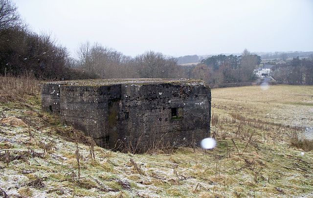
English: Pill Box. South of The river Coquet at Weldon Bridge. This Box sits neatly on (as far as I can tell) the 60 metre contour. Looking North you can see The Anglers Arms at Weldon Bridge to the right of the pill box. This box is part of the Coquet defence line and was constructed between 1940 and 1941. The view of the Pill box from the North can be seen in this 1715820
The white spot in lower right corner of the facing wall is a snow flake. |
| Date | |
| Source | From geograph.org.uk |
| Author | David Clark |
| Attribution (required by the license) | David Clark / Pill Box / |
| Camera location | | View this and other nearby images on: OpenStreetMap |
|---|
_heading:315.00&language=en)
| Object location | | View this and other nearby images on: OpenStreetMap |
|---|
_heading:315.00&language=en)
Licensing
[edit]

|
This image was taken from the Geograph project collection. See this photograph's page on the Geograph website for the photographer's contact details. The copyright on this image is owned by David Clark and is licensed for reuse under the Creative Commons Attribution-ShareAlike 2.0 license.
|
This file is licensed under the Creative Commons Attribution-Share Alike 2.0 Generic license.
Attribution: David Clark
- You are free:
- to share – to copy, distribute and transmit the work
- to remix – to adapt the work
- Under the following conditions:
- attribution – You must give appropriate credit, provide a link to the license, and indicate if changes were made. You may do so in any reasonable manner, but not in any way that suggests the licensor endorses you or your use.
- share alike – If you remix, transform, or build upon the material, you must distribute your contributions under the same or compatible license as the original.
File history
Click on a date/time to view the file as it appeared at that time.
| Date/Time | Thumbnail | Dimensions | User | Comment | |
|---|---|---|---|---|---|
| current | 09:00, 5 March 2011 | | 3,990 × 2,523 (3.84 MB) | GeographBot (talk | contribs) | == {{int:filedesc}} == {{Information |description={{en|1=Pill Box South of The river Coquet at Weldon Bridge. This Box sits neatly on (as far as I can tell) the 6o metre contour. Looking North you can see The Anglers Arms at Weldon Bridge to the right of |
You cannot overwrite this file.
File usage on Commons
There are no pages that use this file.