File:PikiWiki Israel 70932 in the compound of deir rafat monastery.jpg
![File:PikiWiki Israel 70932 in the compound of deir rafat monastery.jpg](https://upload.wikimedia.org/wikipedia/commons/thumb/a/a1/PikiWiki_Israel_70932_in_the_compound_of_deir_rafat_monastery.jpg/450px-PikiWiki_Israel_70932_in_the_compound_of_deir_rafat_monastery.jpg?20200818012942)
Original file (2,414 × 3,218 pixels, file size: 1.66 MB, MIME type: image/jpeg)
Captions
Captions
DescriptionPikiWiki Israel 70932 in the compound of deir rafat monastery.jpg |
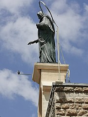
English: In the compound of Deir Rafat Monastery עברית: במתחם מנזר דיר ראפאת
Original Image Name: Piciwiki_israel_70932_IMG_20200808_152403.jpg Notes: דיר ראפאת הוא מנזר קתולי מערבית לקיבוץ צרעה ושוכנות בו נזירות. בעבר היה במקום כפר ערבי בשם ראפאת. הכפר נכבש במלחמת השחרור על ידי כוחות חטיבת פלמquotח הראל במבצע דני. בתי הכפר שנותרו מושכרים על ידי הכנסייה הקתולית. באמצע המאה ה-19 חלק משטחו נמכר לפטריארכיה הלטינית. המנזר והכנסייה הוקמו בשנת 1927 . קירות הכנסייה ותקרתה מקושטים במילות ברכה ב280 שפות. גם על דלתות העץ של הכנסייה כתובה הברכה ב 56 שפות שונות. המנזר מוחזק על ידי מסדר הנזירות בית לחם . בראש מבנה המנזר פסל גבוה עם דמות מרים מברונזה. Location: דיר ראפאת |
Date | |
Source | Heritage Conservation Outside The City via the PikiWiki - Israel free image collection project |
Author | ישראל פרקר Israel Preker |
Permission (Reusing this file) |
![]() ![]() This file is licensed under the Creative Commons Attribution 2.5 Generic license. Attribution: Heritage Conservation Outside The City Pikiwiki Israel
|
Camera location | 31° 46′ 34.28″ N, 34° 56′ 50.83″ E ![]() | View this and other nearby images on: OpenStreetMap | ![]() |
---|
![]() |
This file has been submitted through the Israeli Pikiwiki project and uploaded here automatically.
The project is cooperation between the Israel Internet Association and Wikimedia Israel in an effort to promote the concept of free content on the Web, by creating an image collection of digital-format, good quality photographs, documenting events relating to the history of Israel, or depicting places of distinction in Israel and the Middle East. The Pikiwiki Project is managed from 2021 by the "Heritage Stones" group.
Please consider notifying the project before renaming or deleting this file. Further information about the project can be found on the commons-l mailing list.
|
![]() |
File history
Click on a date/time to view the file as it appeared at that time.
Date/Time | Thumbnail | Dimensions | User | Comment | |
---|---|---|---|---|---|
current | 01:29, 18 August 2020 | ![]() | 2,414 × 3,218 (1.66 MB) | Pikiwikisrael (talk | contribs) |
You cannot overwrite this file.
File usage on Commons
There are no pages that use this file.
Metadata
This file contains additional information such as Exif metadata which may have been added by the digital camera, scanner, or software program used to create or digitize it. If the file has been modified from its original state, some details such as the timestamp may not fully reflect those of the original file. The timestamp is only as accurate as the clock in the camera, and it may be completely wrong.
Image title | oznorCBT |
---|---|
Camera manufacturer | HUAWEI |
Camera model | VOG-L29 |
ISO speed rating | 50 |
F-number | f/1.6 |
Exposure time | 83/500,000 sec (0.000166) |
Lens focal length | 5.56 mm |
Date and time of data generation | 11:30, 8 August 2020 |
Latitude | 31° 46′ 34.28″ N |
Longitude | 34° 56′ 50.83″ E |
Altitude | 0 meters above sea level |
Width | 2,414 px |
Height | 3,218 px |
Bits per component |
|
Software used | VOG-L29 9.1.0.260(C431E4R2P2) |
Orientation | Normal |
File change date and time | 15:24, 8 August 2020 |
Y and C positioning | Centered |
Horizontal resolution | 72 dpi |
Vertical resolution | 72 dpi |
Exposure Program | Normal program |
Sensing method | One-chip color area sensor |
DateTimeDigitized subseconds | 411112 |
DateTimeOriginal subseconds | 411112 |
DateTime subseconds | 411112 |
Subject distance range | Unknown |
Sharpness | Normal |
Flash | Flash did not fire |
Saturation | Normal |
Light source | Daylight |
Contrast | Normal |
Metering mode | Pattern |
Scene control | None |
Scene capture type | Standard |
Focal length in 35 mm film | 100 mm |
Maximum land aperture | 1.35 APEX (f/1.6) |
Digital zoom ratio | 1 |
APEX exposure bias | 0 |
Date and time of digitizing | 11:30, 8 August 2020 |
White balance | Auto white balance |
APEX brightness | 0 |
Exposure mode | Auto exposure |
Image compression mode | 0.95 |
APEX aperture | 1.35 |
Meaning of each component |
|
Color space | sRGB |
Scene type | A directly photographed image |
Custom image processing | Custom process |
APEX shutter speed | 29.8973 |
Exif version | 2.1 |
Supported Flashpix version | 1 |
File source | Digital still camera |
GPS time (atomic clock) | 08:30 |
GPS date | 8 August 2020 |
GPS tag version | 2.2.0.0 |