File:Philippe Briet, Palestinæ delineatio ad geographiae canones revocata (FL199985262 2368393).jpg
Jump to navigation
Jump to search

Size of this preview: 796 × 600 pixels. Other resolutions: 319 × 240 pixels | 637 × 480 pixels | 1,019 × 768 pixels | 1,280 × 965 pixels | 2,560 × 1,929 pixels | 9,544 × 7,192 pixels.
Original file (9,544 × 7,192 pixels, file size: 47.03 MB, MIME type: image/jpeg)
Captions
Captions
Add a one-line explanation of what this file represents
Summary
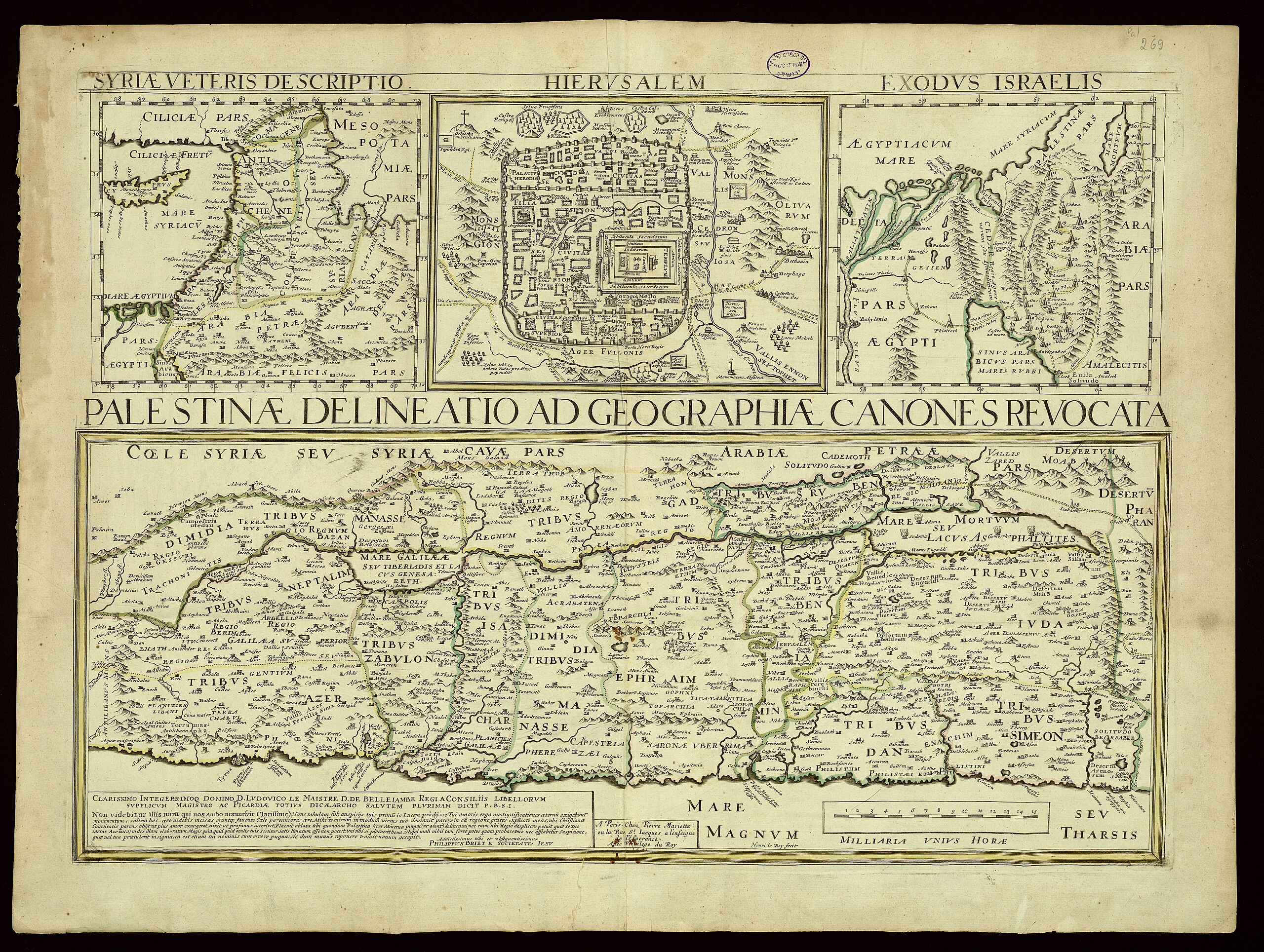
[edit]| Philippus Brietius: Palestinæ delineatio ad geographiae canones revocata
( |
||||||||||||||||||||||||
|---|---|---|---|---|---|---|---|---|---|---|---|---|---|---|---|---|---|---|---|---|---|---|---|---|
| Artist |
| |||||||||||||||||||||||
| Contributors | Mariette, Pierre, 1603-1657 La Rué, Philippe de Le Roy, Henri | |||||||||||||||||||||||
| Title |
Palestinæ delineatio ad geographiae canones revocata |
|||||||||||||||||||||||
| Publisher |
chez Pierre Mariette |
|||||||||||||||||||||||
| Description |
Palestinæ delineatio ad geographiae canones revocata. Philippus Briet a Societate Iesu. Henri le Roy fecit. |
|||||||||||||||||||||||
| Language | Latin | |||||||||||||||||||||||
| Publication date | 1641 | |||||||||||||||||||||||
| Medium | 4 maps on 1 sheet ; | |||||||||||||||||||||||
| Dimensions | height: 45 cm (17.7 in); width: 61 cm (24 in) | |||||||||||||||||||||||
| Collection |
|
|||||||||||||||||||||||
| Current location |
|
|||||||||||||||||||||||
| Place of publication | Paris | |||||||||||||||||||||||
| search Merhav catalog | Paris | |||||||||||||||||||||||
| Notes | Copperplate; Three small maps above the title of the main map: Syriae veteris descriptio, Hierusalem, Exodus Israelis.; From: La Rue, Philippe de. La Terre Saincte en six cartes geographiques. Paris, Pierre Mariette, 1651 | |||||||||||||||||||||||
| IE PID | IE199985260 | |||||||||||||||||||||||
| Rosetta filename | FL199985262 | |||||||||||||||||||||||
| NNL item ID (P3959) | 990023683930205171 | |||||||||||||||||||||||
| search Merhav catalog | Latin, Philippus Brietius | |||||||||||||||||||||||
| search Merhav catalog | chez Pierre Mariette | |||||||||||||||||||||||
| Source/Photographer |
|
|||||||||||||||||||||||
| Other versions | ||||||||||||||||||||||||
| Jpg / Tif version |
|
|||||||||||||||||||||||

.jpg)

.jpg&action=edit§ion=1)
Licensing
[edit].jpg&action=edit§ion=2)
The copyright situation of this work is theoretically uncertain, because in the country of origin copyright lasts 70 years after the death of the author, and the date of the author's death is unknown. However, the date of creation of the work was over 120 years ago, and it is thus a reasonable assumption that the copyright has expired (see here for the community discussion). Do not use this template if the date of death of the author is known.
| |
| This file has been identified as being free of known restrictions under copyright law, including all related and neighboring rights. | |
File history
Click on a date/time to view the file as it appeared at that time.
| Date/Time | Thumbnail | Dimensions | User | Comment | |
|---|---|---|---|---|---|
| current | 06:41, 28 July 2023 | | 9,544 × 7,192 (47.03 MB) | Geagea (talk | contribs) | pattypan 22.03 |
You cannot overwrite this file.
File usage on Commons
The following page uses this file:
.jpg&oldid=788133539)