File:Ph davao region.png
Jump to navigation
Jump to search
Size of this preview: 373 × 599 pixels. Other resolutions: 149 × 240 pixels | 299 × 480 pixels | 478 × 768 pixels | 1,144 × 1,838 pixels.
Original file (1,144 × 1,838 pixels, file size: 270 KB, MIME type: image/png)
Captions
Captions
Add a one-line explanation of what this file represents

|
This image could be re-created using vector graphics as an SVG file. This has several advantages; see Commons:Media for cleanup for more information. If an SVG form of this image is available, please upload it and afterwards replace this template with
{{vector version available|new image name}}.
It is recommended to name the SVG file “Ph davao region.svg”—then the template Vector version available (or Vva) does not need the new image name parameter. |
Summary
[edit]
| Description |
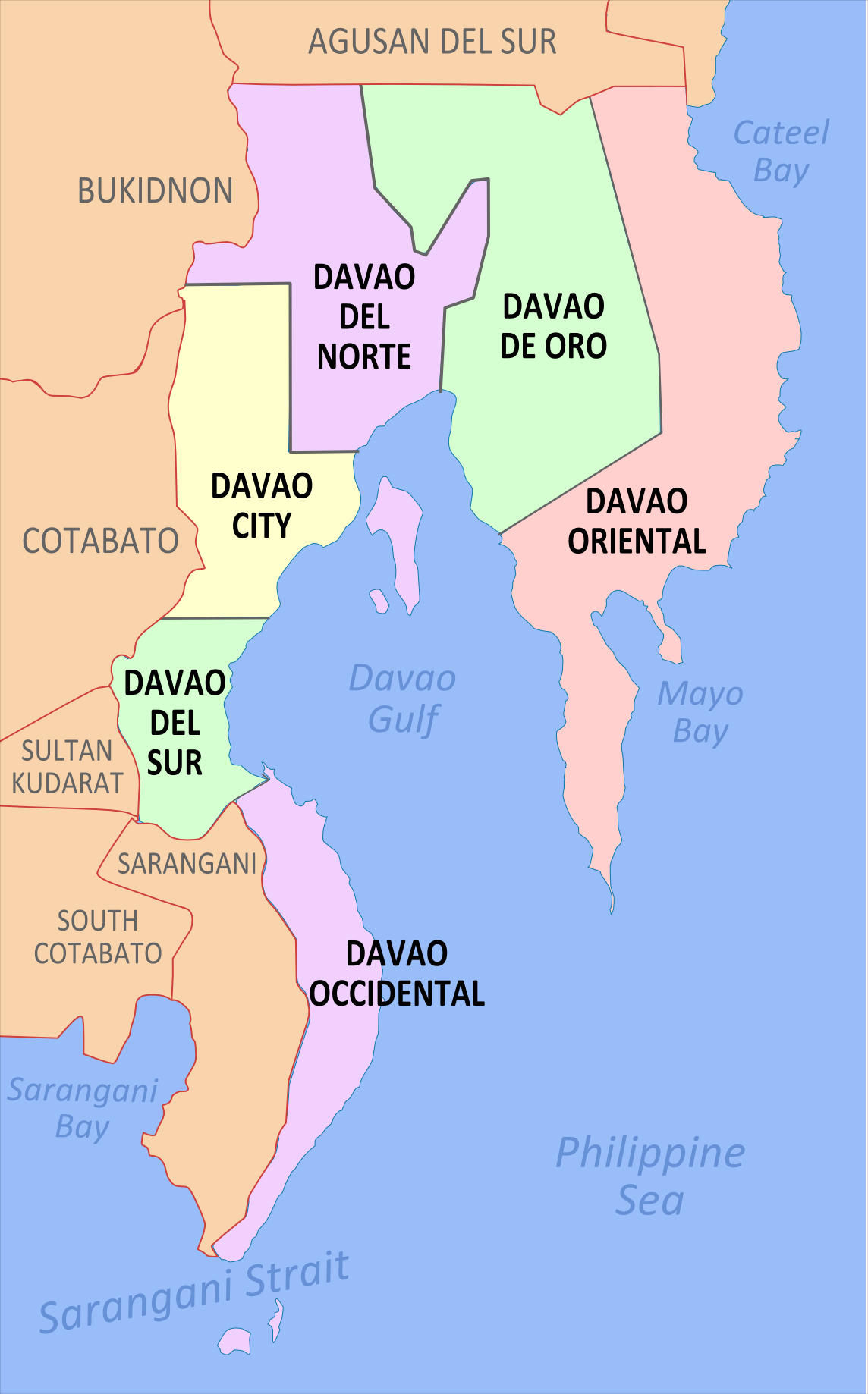
English: Political Map of Davao Region, Philippines. Showing Compostela Valley, Davao del Norte, Davao del Sur, Davao Oriental and Davao City. Used the map template :Image:BlankMap-Philippines.png by User:TheCoffee. |
| Date | 3 May 2007 (original upload date) |
| Source | Transferred from en.wikipedia to Commons. |
| Author | Namayan at English Wikipedia |
Licensing
[edit]
Namayan at English Wikipedia, the copyright holder of this work, hereby publishes it under the following licenses:

|
Permission is granted to copy, distribute and/or modify this document under the terms of the GNU Free Documentation License, Version 1.2 or any later version published by the Free Software Foundation; with no Invariant Sections, no Front-Cover Texts, and no Back-Cover Texts. A copy of the license is included in the section entitled GNU Free Documentation License. |
| This file is licensed under the Creative Commons Attribution-Share Alike 3.0 Unported license. | ||
| Attribution: Namayan at English Wikipedia | ||
| ||
| This licensing tag was added to this file as part of the GFDL licensing update. |
This file is licensed under the Creative Commons Attribution 2.5 Generic license.
Attribution: Namayan at English Wikipedia
- You are free:
- to share – to copy, distribute and transmit the work
- to remix – to adapt the work
- Under the following conditions:
- attribution – You must give appropriate credit, provide a link to the license, and indicate if changes were made. You may do so in any reasonable manner, but not in any way that suggests the licensor endorses you or your use.
You may select the license of your choice.
Original upload log
[edit]
The original description page was here. All following user names refer to en.wikipedia.
- 2007-05-03 06:27 Namayan 355×589× (31591 bytes) edited image
File history
Click on a date/time to view the file as it appeared at that time.
| Date/Time | Thumbnail | Dimensions | User | Comment | |
|---|---|---|---|---|---|
| current | 19:16, 28 November 2021 | | 1,144 × 1,838 (270 KB) | Magog the Ogre (talk | contribs) | Reverted to version as of 04:44, 26 November 2021 (UTC) |
| 03:36, 28 November 2021 | No thumbnail | 2,000 × 3,526 (498 KB) | Sanchezph (talk | contribs) | Reverted to version as of 03:47, 26 November 2021 (UTC) | |
| 04:44, 26 November 2021 |  | 1,144 × 1,838 (270 KB) | Hariboneagle927 (talk | contribs) | Reverted to version as of 08:56, 30 March 2021 (UTC) | |
| 03:47, 26 November 2021 | No thumbnail | 2,000 × 3,526 (498 KB) | Nissan2020 (talk | contribs) | Reverted to version as of 11:32, 28 March 2021 (UTC) | |
| 08:56, 30 March 2021 |  | 1,144 × 1,838 (270 KB) | HueMan1 (talk | contribs) | Reverted to version as of 15:33, 14 May 2020 (UTC) | |
| 11:32, 28 March 2021 | No thumbnail | 2,000 × 3,526 (498 KB) | Teamayuiyui (talk | contribs) | Update from 2021 | |
| 15:33, 14 May 2020 |  | 1,144 × 1,838 (270 KB) | HueMan1 (talk | contribs) | Reverted to version as of 18:46, 28 January 2020 (UTC) | |
| 18:46, 28 January 2020 |  | 1,144 × 1,838 (270 KB) | Exec8 (talk | contribs) | Font adjustment | |
| 18:45, 28 January 2020 |  | 1,144 × 1,838 (278 KB) | Exec8 (talk | contribs) | Updated Davao Occidental and Davao de Oro | |
| 10:51, 2 August 2012 |  | 355 × 589 (31 KB) | Urdangaray (talk | contribs) | {{Information |Description={{en|Political Map of en:Davao Region, en:Philippines. Showing en:Compostela Valley, en:Davao del Norte, en:Davao del Sur, en:Davao Oriental and en:Davao City. Used the map template [... |
You cannot overwrite this file.
File usage on Commons
The following page uses this file:
File usage on other wikis
The following other wikis use this file:
- Usage on bcl.wikipedia.org
- Usage on ceb.wikipedia.org
- Usage on en.wikipedia.org
- Usage on es.wikipedia.org
- Usage on ka.wikipedia.org
- დავაო
- დავაოს რეგიონი
- დავაო-დე-ორო
- თარგი:დავაოს რეგიონი
- კომპოსტელა (დავაო-დე-ორო)
- ლააკი (დავაო-დე-ორო)
- მაბინი (დავაო-დე-ორო)
- მაკო (დავაო-დე-ორო)
- მარაგუსანი
- მავაბი
- მონკაიო
- მონტევისტა
- ნაბუნტურანი
- ახალი ბატაანი
- პანტუკანი
- ბანსალანი
- აგონოი (სამხრეთი დავაო)
- კიბლავანი
- მატანაო
- მალალაგი
- მაგსაისაი (სამხრეთი დავაო)
- პადადა
- სანტა-კრუსი (სამხრეთი დავაო)
- სულოპი
- ასუნსიონი (ჩრდილოეთი დავაო)
- ბრაულიო-ე.-დუხალი
- კაპალონგი
- კარმენი (ჩრდილოეთი დავაო)
- ახალი კორელია
- სან-ისიდრო (ჩრდილოეთი დავაო)
- ტალაინგოდი
- სანტო-ტომასი (ჩრდილოეთი დავაო)
View more global usage of this file.