File:Peter Colley Tavern.jpg
Jump to navigation
Jump to search

Size of this preview: 800 × 600 pixels. Other resolutions: 320 × 240 pixels | 640 × 480 pixels | 1,024 × 768 pixels | 1,280 × 960 pixels | 2,560 × 1,920 pixels | 2,816 × 2,112 pixels.
Original file (2,816 × 2,112 pixels, file size: 3.33 MB, MIME type: image/jpeg)
Captions
Captions
Add a one-line explanation of what this file represents
|
This is an image of a place or building that is listed on the National Register of Historic Places in the United States of America. Its reference number is 73001630. |
| Camera location | | View this and other nearby images on: OpenStreetMap |
|---|
| Description |
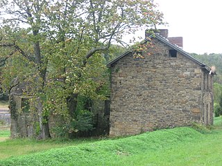
English: Eastern side of the Peter Colley Tavern, formerly a prominent tavern located on the old National Road (now U.S. Route 40) at Brier Hill in Redstone Township, Fayette County, Pennsylvania, United States. Built in 1796, it is listed on the National Register of Historic Places, together with an associated barn; both are part of the Brier Hill Historic District, which is also listed on the Register. |
||
| Date | Taken on 30 September 2011 | ||
| Source | Own work | ||
| Author | Nyttend | ||
| Permission (Reusing this file) |
|
File history
Click on a date/time to view the file as it appeared at that time.
| Date/Time | Thumbnail | Dimensions | User | Comment | |
|---|---|---|---|---|---|
| current | 05:30, 13 November 2011 | | 2,816 × 2,112 (3.33 MB) | Nyttend (talk | contribs) | {{Location|39|58|49|N|79|49|53|W}} {{Information |Description={{en|Eastern side of the {{w|Peter Colley Tavern and Barn|Peter Colley Tavern}}, formerly a prominent tavern located on the old National Road (now {{w|U.S. Route 40}}) at {{w|Brier Hill, Pennsy |
You cannot overwrite this file.
File usage on Commons
There are no pages that use this file.
File usage on other wikis
The following other wikis use this file:
- Usage on en.wikipedia.org
- Usage on www.wikidata.org
Metadata
Categories:
- Houses built in Pennsylvania in 1796
- Former hotels in Pennsylvania
- Historic districts in Fayette County, Pennsylvania
- National Register of Historic Places in Fayette County, Pennsylvania
- Sandstone buildings in Pennsylvania
- Taverns in Pennsylvania
- U.S. Route 40 in Pennsylvania
- Redstone Township, Fayette County, Pennsylvania