File:Peruvian Altiplano.jpg
Jump to navigation
Jump to search

Size of this preview: 800 × 450 pixels. Other resolutions: 320 × 180 pixels | 640 × 360 pixels | 1,024 × 576 pixels | 1,280 × 720 pixels | 3,080 × 1,733 pixels.
Original file (3,080 × 1,733 pixels, file size: 3.13 MB, MIME type: image/jpeg)
Captions
Captions
Add a one-line explanation of what this file represents
Summary
[edit]
| Description |
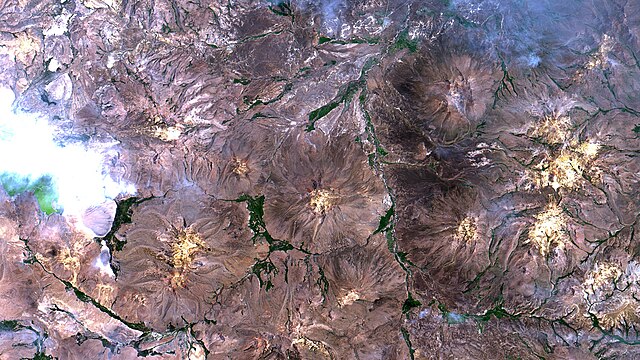
Português: Altiplano Peruano em El Collao, Santa Rosa, Perú. A cerca de 90km a SO do Lago Titicaca, toda região está a quase 4.000 m de altitude, e é composta por bacias endorréicas que, aqui, drenam para o Titicaca através do Rio Huenque, à dir. da imagem correndo de S para N. Em verde vegetação de puna úmida na várzea dos rios. Em marrom e amarelo, puna seca / Peruvian Altiplano at El Collao, Santa Rosa, Peru. About 55 miles SW of Titicaca Lake, all region is almost at 13,000 ft, and composed of endorheic basins, here draining to Titicaca through Huenque River, running from S to N at image right side. Wet puna vegetation in green at river floodplains. In brown and yellow, dry puna.
Imagem / Image CBERS4 MUX Altiplano Peruano / Peruvian Altiplano Coordenadas do centro da imagem / Image center: 16°53'28.5"S 69°47'47.0"W Data / Date: 08-01-2020 / 2020-08-01 RGB 765 (cor verdadeira / true color) Cena / Scene: 180 / 119 Autor / Author: Oton Barros (DSR/OBT/INPE) Imagem em HD / HD Image Visite-nos em www.dsr.inpe.br |
| Date | |
| Source | https://www.flickr.com/photos/153282474@N02/49363103616/ |
| Author | Coordenação-Geral de Observação da Terra/INPE |
Licensing
[edit]
This file is licensed under the Creative Commons Attribution-Share Alike 2.0 Generic license.
- You are free:
- to share – to copy, distribute and transmit the work
- to remix – to adapt the work
- Under the following conditions:
- attribution – You must give appropriate credit, provide a link to the license, and indicate if changes were made. You may do so in any reasonable manner, but not in any way that suggests the licensor endorses you or your use.
- share alike – If you remix, transform, or build upon the material, you must distribute your contributions under the same or compatible license as the original.
| This image was originally posted to Flickr by Coordenação-Geral de Observação da Terra/INPE at https://flickr.com/photos/153282474@N02/49363103616. It was reviewed on 9 April 2020 by FlickreviewR 2 and was confirmed to be licensed under the terms of the cc-by-sa-2.0. |
File history
Click on a date/time to view the file as it appeared at that time.
| Date/Time | Thumbnail | Dimensions | User | Comment | |
|---|---|---|---|---|---|
| current | 10:12, 9 April 2020 | | 3,080 × 1,733 (3.13 MB) | Jo-Jo Eumerus (talk | contribs) | Uploaded a work by Coordenação-Geral de Observação da Terra/INPE from https://www.flickr.com/photos/153282474@N02/49363103616/ with UploadWizard |
You cannot overwrite this file.
File usage on Commons
The following 2 pages use this file:
.jpg&redirect=no)