File:Perthshire - British Isles.svg
Jump to navigation
Jump to search

Size of this PNG preview of this SVG file: 408 × 599 pixels. Other resolutions: 163 × 240 pixels | 327 × 480 pixels | 523 × 768 pixels | 697 × 1,024 pixels | 1,395 × 2,048 pixels | 1,250 × 1,835 pixels.
Original file (SVG file, nominally 1,250 × 1,835 pixels, file size: 1,024 KB)
Captions
Captions
Add a one-line explanation of what this file represents
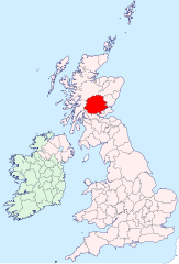
| Description | Perthshire location map | ||
| Date | |||
| Source | British Isles in counties.svg | ||
| Author | User:Visitor from Wikishire | ||
| Permission (Reusing this file) |
|
File history
Click on a date/time to view the file as it appeared at that time.
| Date/Time | Thumbnail | Dimensions | User | Comment | |
|---|---|---|---|---|---|
| current | 15:32, 5 October 2024 | | 1,250 × 1,835 (1,024 KB) | Visitor from Wikishire (talk | contribs) | Mending my error |
| 22:04, 4 October 2024 |  | 1,250 × 1,835 (1,011 KB) | Visitor from Wikishire (talk | contribs) | Minor corrections | |
| 20:13, 12 September 2019 |  | 1,250 × 1,835 (1,002 KB) | Hogweard (talk | contribs) | Colours | |
| 20:04, 13 January 2015 |  | 1,250 × 1,835 (933 KB) | Visitor from Wikishire (talk | contribs) | {{Information |Description=Perthshire location map |Source=British Isles in counties.svg |Date=2014-01-11 |Author=User:Visitor from Wikishire |Permission={{PD-self}} |other_versions= }} [[Category:Maps of his... |
You cannot overwrite this file.
File usage on Commons
There are no pages that use this file.
File usage on other wikis
The following other wikis use this file:
- Usage on ang.wikipedia.org
- Usage on ku.wikipedia.org
- Usage on nl.wikipedia.org
- Usage on tr.wikipedia.org
- Usage on www.wikidata.org