File:Perth Railway map.png
Jump to navigation
Jump to search

Size of this preview: 469 × 600 pixels. Other resolutions: 188 × 240 pixels | 375 × 480 pixels | 601 × 768 pixels | 801 × 1,024 pixels | 2,188 × 2,797 pixels.
Original file (2,188 × 2,797 pixels, file size: 304 KB, MIME type: image/png)
Captions
Captions
Add a one-line explanation of what this file represents
Summary
[edit]

|
This transport map image could be re-created using vector graphics as an SVG file. This has several advantages; see Commons:Media for cleanup for more information. If an SVG form of this image is available, please upload it and afterwards replace this template with
{{vector version available|new image name}}.
It is recommended to name the SVG file “Perth Railway map.svg”—then the template Vector version available (or Vva) does not need the new image name parameter. |
| Description |
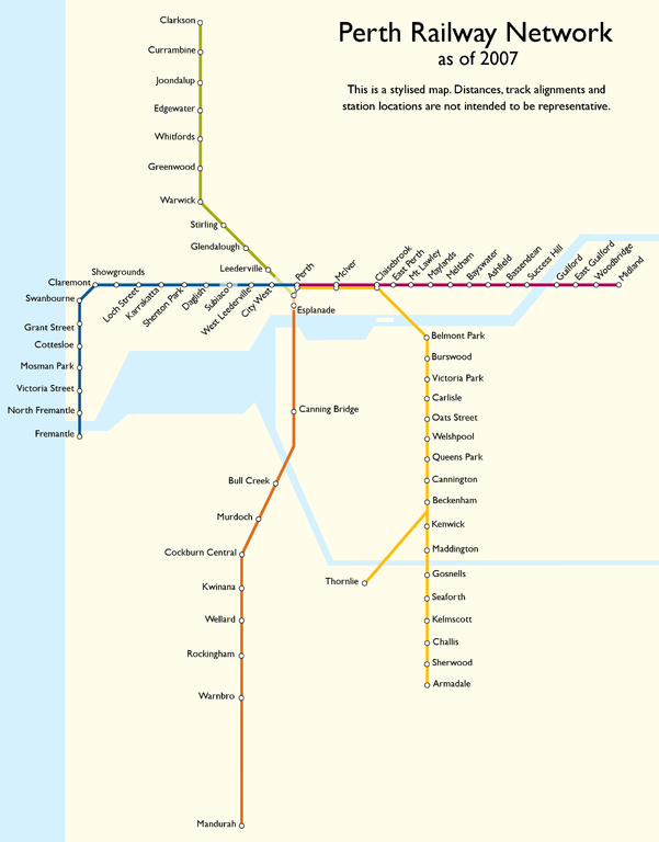
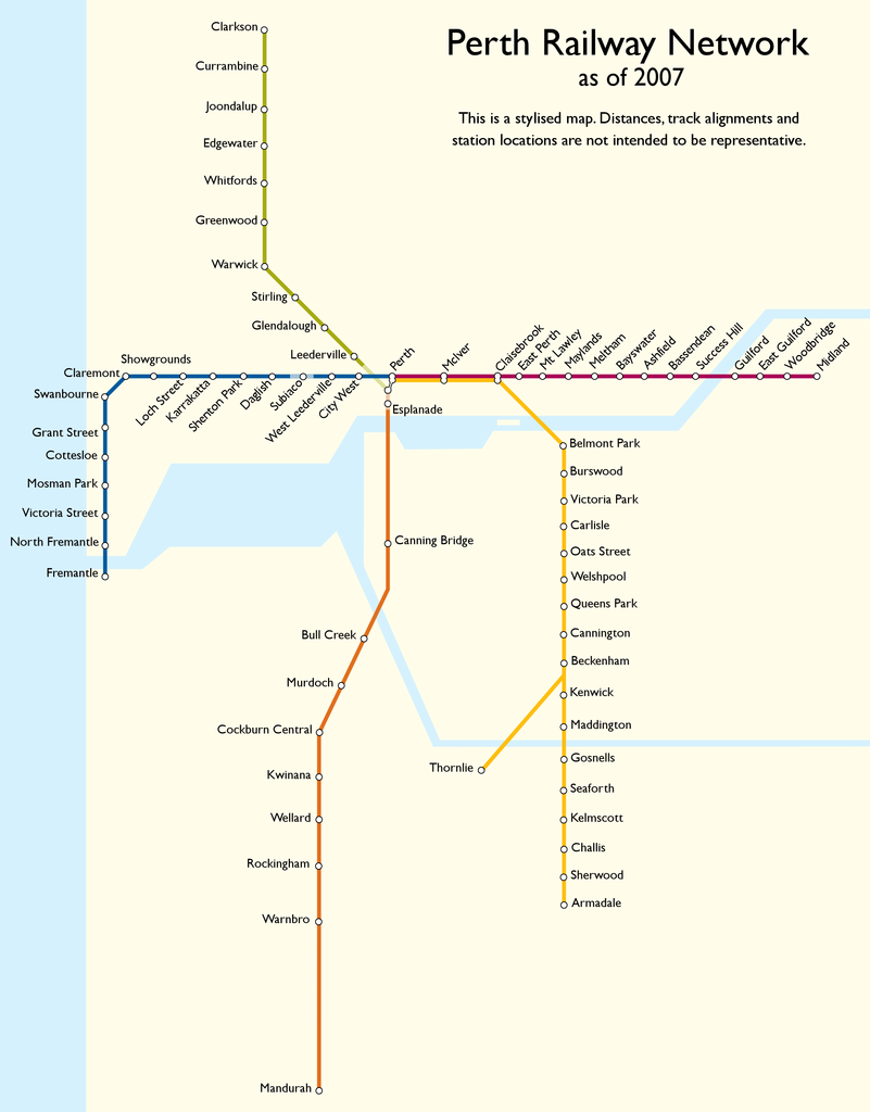
English: Stylised map of the Perth suburban railway network. Created using Paint Shop Pro 9. |
| Date | 13 February 2007 (original upload date) |
| Source | Transferred from en.wikipedia |
| Author | Mark Ryan, aka Mark at en.wikipedia |
Licensing
[edit]
Mark, the copyright holder of this work, hereby publishes it under the following license:

|
Permission is granted to copy, distribute and/or modify this document under the terms of the GNU Free Documentation License, Version 1.2 or any later version published by the Free Software Foundation; with no Invariant Sections, no Front-Cover Texts, and no Back-Cover Texts. A copy of the license is included in the section entitled GNU Free Documentation License. |
Original upload log
[edit]
The original description page was here. All following user names refer to en.wikipedia.
- 2007-02-13 08:38 Mark 2188×2797× (310921 bytes) Stylised map of the Perth suburban railway network. Created by [[User:Mark|Mark Ryan]] using Paint Shop Pro 9.
File history
Click on a date/time to view the file as it appeared at that time.
| Date/Time | Thumbnail | Dimensions | User | Comment | |
|---|---|---|---|---|---|
| current | 03:42, 23 January 2011 | | 2,188 × 2,797 (304 KB) | File Upload Bot (Magnus Manske) (talk | contribs) | {{BotMoveToCommons|en.wikipedia|year={{subst:CURRENTYEAR}}|month={{subst:CURRENTMONTHNAME}}|day={{subst:CURRENTDAY}}}} {{Information |Description={{en|Stylised map of the Perth suburban railway network. Created by Mark Ryan using Paint |
You cannot overwrite this file.
File usage on Commons
There are no pages that use this file.