File:Perspektivischer Blick nach Süden auf das chaotische Gebiet.jpg
Jump to navigation
Jump to search

Size of this preview: 800 × 450 pixels. Other resolutions: 320 × 180 pixels | 640 × 360 pixels | 1,024 × 576 pixels | 1,280 × 720 pixels | 1,920 × 1,080 pixels.
Original file (1,920 × 1,080 pixels, file size: 1.41 MB, MIME type: image/jpeg)
Captions
Captions
Add a one-line explanation of what this file represents
Summary
[edit]
| Description |
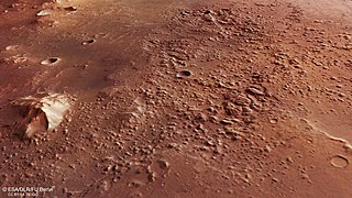
English: Dieses ‚chaotische Gebiet‘ (engl. chaotic terrain) befindet sich an der tiefsten Stelle einer großen, bis zu 2000 Meter tiefen Senke und durchmisst etwa 40 mal 80 Kilometer. Solche zerbrochenen Landschaftsformen entstehen, wenn Eisreservoire im Untergrund zum Beispiel durch vulkanisch induzierte Wärme schmelzen und beträchtliche Mengen Wasser ganz plötzlich freigesetzt werden und abfließen. Dadurch kollabiert die Oberfläche über den neu entstandenen Hohlräumen und die Landschaft stürzt in sich zusammen. Der genaue Auslöser für die Bildung des chaotischen Gebiets hier an dieser Stelle ist bis heute noch unklar.
Mehr dazu: www.dlr.de/content/de/artikel/news/2022/03/20220831_ein-t... Über die Mission Mars Express: www.dlr.de/mars Credit: ESA/DLR/FU Berlin – CC BY-SA 3.0 IGO |
| Date | Taken on 5 August 2022 16:41:48 |
| Source | https://www.flickr.com/photos/dlr_de/52324192503/ |
| Author | DLR German Aerospace Center |
Licensing
[edit]
This file is licensed under the Creative Commons Attribution-Share Alike 2.0 Generic license.
- You are free:
- to share – to copy, distribute and transmit the work
- to remix – to adapt the work
- Under the following conditions:
- attribution – You must give appropriate credit, provide a link to the license, and indicate if changes were made. You may do so in any reasonable manner, but not in any way that suggests the licensor endorses you or your use.
- share alike – If you remix, transform, or build upon the material, you must distribute your contributions under the same or compatible license as the original.
| This image was originally posted to Flickr by DLR_de at https://flickr.com/photos/48213136@N06/52324192503. It was reviewed on 31 August 2022 by FlickreviewR 2 and was confirmed to be licensed under the terms of the cc-by-sa-2.0. |
This file is licensed under the Creative Commons Attribution-ShareAlike 3.0 IGO license.
- You are free:
- to share – to copy, distribute and transmit the work
- to remix – to adapt the work
- Under the following conditions:
- attribution – You must give appropriate credit, provide a link to the license, and indicate if changes were made. You may do so in any reasonable manner, but not in any way that suggests the licensor endorses you or your use.
- share alike – If you remix, transform, or build upon the material, you must distribute your contributions under the same or compatible license as the original.
File history
Click on a date/time to view the file as it appeared at that time.
| Date/Time | Thumbnail | Dimensions | User | Comment | |
|---|---|---|---|---|---|
| current | 11:45, 31 August 2022 | | 1,920 × 1,080 (1.41 MB) | Erick Soares3 (talk | contribs) | Uploaded a work by DLR German Aerospace Center from https://www.flickr.com/photos/dlr_de/52324192503/ with UploadWizard |
You cannot overwrite this file.
File usage on Commons
The following page uses this file: