File:Perrette - Plan Timisoara 1716.png
Jump to navigation
Jump to search

Size of this preview: 800 × 600 pixels. Other resolutions: 320 × 240 pixels | 640 × 480 pixels | 1,024 × 768 pixels | 1,280 × 960 pixels | 2,560 × 1,920 pixels | 4,000 × 3,000 pixels.
Original file (4,000 × 3,000 pixels, file size: 21.23 MB, MIME type: image/png)
Captions
Captions
Add a one-line explanation of what this file represents
Summary
[edit]
| Description |
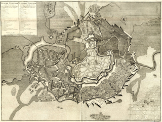
English: Map of Timișoara by cpt. François Perrette, 1716
Română: Harta Timișoarei de cpt. François Perrette, 1716 |
| Date | |
| Source | Mr. [Jean] Rousset [de Missy], A La Haye, Chez Isaac van der Kloot, Histoire militaire du prince Eugene de Savoye, du prince et duc de Marlborough, et du prince de Nassau-Frise. Où l'on trouve un détail des principales Actions de la dernière Guerre, & des Batailles & Sièges commandés par ces trois Généraux. Enrichie des Plans nécessaires, MDCCXXIX (1729) |
| Author | François Perrette |
Licensing
[edit]
|
This work is in the public domain in its country of origin and other countries and areas where the copyright term is the author's life plus 70 years or fewer. | |
| This file has been identified as being free of known restrictions under copyright law, including all related and neighboring rights. | |
File history
Click on a date/time to view the file as it appeared at that time.
| Date/Time | Thumbnail | Dimensions | User | Comment | |
|---|---|---|---|---|---|
| current | 11:39, 15 April 2017 | | 4,000 × 3,000 (21.23 MB) | Turbojet (talk | contribs) | Better resolution |
| 18:39, 11 April 2017 |  | 940 × 700 (1.33 MB) | Turbojet (talk | contribs) | User created page with UploadWizard |
You cannot overwrite this file.
File usage on Commons
The following page uses this file:
- File:Perrette - Plan Timisoara 1916.png (file redirect)
File usage on other wikis
The following other wikis use this file:
- Usage on ro.wikipedia.org
- Usage on sh.wikipedia.org