File:Perfil tajo 10 km.png
Jump to navigation
Jump to search
Size of this preview: 800 × 392 pixels. Other resolutions: 320 × 157 pixels | 640 × 313 pixels | 1,087 × 532 pixels.
Original file (1,087 × 532 pixels, file size: 10 KB, MIME type: image/png)
Captions
Captions
Add a one-line explanation of what this file represents
Summary
[edit]
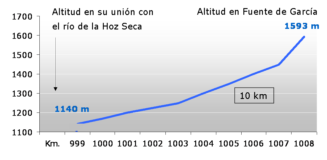
| Description | Perfil del río Tajo en sus primeros 10 kilómetros |
| Date | |
| Source | Own work |
| Author | Esetena |
Licensing
[edit]
I, the copyright holder of this work, hereby publish it under the following licenses:

|
Permission is granted to copy, distribute and/or modify this document under the terms of the GNU Free Documentation License, Version 1.2 or any later version published by the Free Software Foundation; with no Invariant Sections, no Front-Cover Texts, and no Back-Cover Texts. A copy of the license is included in the section entitled GNU Free Documentation License. |
| This file is licensed under the Creative Commons Attribution-Share Alike 3.0 Unported license. | ||
| ||
| This licensing tag was added to this file as part of the GFDL licensing update. |
You may select the license of your choice.
Licensing
[edit]
I, the copyright holder of this work, hereby publish it under the following licenses:
|
|
Permission is granted to copy, distribute and/or modify this document under the terms of the GNU Free Documentation License, Version 1.2 or any later version published by the Free Software Foundation; with no Invariant Sections, no Front-Cover Texts, and no Back-Cover Texts. A copy of the license is included in the section entitled GNU Free Documentation License. |
| This file is licensed under the Creative Commons Attribution-Share Alike 3.0 Unported license. | ||
| ||
| This licensing tag was added to this file as part of the GFDL licensing update. |
| Copyleft: This work of art is free; you can redistribute it and/or modify it according to terms of the Free Art License. You will find a specimen of this license on the Copyleft Attitude site as well as on other sites. |
You may select the license of your choice.
File history
Click on a date/time to view the file as it appeared at that time.
| Date/Time | Thumbnail | Dimensions | User | Comment | |
|---|---|---|---|---|---|
| current | 20:28, 19 November 2007 | | 1,087 × 532 (10 KB) | Esetena (talk | contribs) | == Sumario == == Sumario == {{Information |Description=Perfil de altitud del río Tajo en sus primeros 10 kilómetros |Source=self-made |Date=nov 19th, 2007 |Author= Esetena |Permission=yes |other_versions= }} Category:Tagus River [[C |
| 20:13, 19 November 2007 |  | 1,229 × 603 (10 KB) | Esetena (talk | contribs) | == Sumario == {{Information |Description=Perfil del río Tajo en sus primeros 10 kilómetros |Source=self-made |Date=nov 19th, 2007 |Author= Esetena |Permission=yes |other_versions= }} Category:Tagus River [[Category:Maps of rivers of |
You cannot overwrite this file.
File usage on Commons
There are no pages that use this file.
File usage on other wikis
The following other wikis use this file:
- Usage on ast.wikipedia.org
- Usage on es.wikipedia.org
- Usage on ja.wikipedia.org
- Usage on pt.wikipedia.org