File:Perapohjola.png
Jump to navigation
Jump to search
No higher resolution available.
Perapohjola.png (230 × 400 pixels, file size: 7 KB, MIME type: image/png)
Captions
Captions
Add a one-line explanation of what this file represents
Summary
[edit]
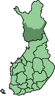
Location of Peräpohjola, the southern part of the Finnish province of Lapland.
Source: self-made, based on ImageSuomen-maakunnat-template.png
Date: 2006-09-28
Author: BishkekRocks
Licensing
[edit]

|
Permission is granted to copy, distribute and/or modify this document under the terms of the GNU Free Documentation License, Version 1.2 or any later version published by the Free Software Foundation; with no Invariant Sections, no Front-Cover Texts, and no Back-Cover Texts. A copy of the license is included in the section entitled GNU Free Documentation License. |
| This file is licensed under the Creative Commons Attribution-Share Alike 3.0 Unported license. | ||
| ||
| This licensing tag was added to this file as part of the GFDL licensing update. |

|
File:Peräpohjola.svg is a vector version of this file. It should be used in place of this PNG file.
File:Perapohjola.png → File:Peräpohjola.svg
For more information, see Help:SVG. |
 |
File history
Click on a date/time to view the file as it appeared at that time.
| Date/Time | Thumbnail | Dimensions | User | Comment | |
|---|---|---|---|---|---|
| current | 10:17, 28 September 2006 | | 230 × 400 (7 KB) | BishkekRocks (talk | contribs) | Location of Peräpohjola, the southern part of the Finnish province of Lapland. Source: self-made, based on ImageSuomen-maakunnat-template.png Date: 2006-09-28 Author: ~~~ Category:Maps of Finland |
You cannot overwrite this file.
File usage on Commons
There are no pages that use this file.