File:Pensacola International Airport Diagram.svg
Jump to navigation
Jump to search

Size of this PNG preview of this SVG file: 390 × 599 pixels. Other resolutions: 156 × 240 pixels | 312 × 480 pixels | 500 × 768 pixels | 667 × 1,024 pixels | 1,334 × 2,048 pixels | 605 × 929 pixels.
Original file (SVG file, nominally 605 × 929 pixels, file size: 878 KB)
Captions
Captions
Add a one-line explanation of what this file represents
Summary
[edit]
| Description |
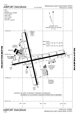
English: Pensacola International Airport |
| Date | |
| Source | http://aeronav.faa.gov/d-tpp/1210/00318AD.PDF |
| Author | FAA - US Federal Government |
| Camera location | | View this and other nearby images on: OpenStreetMap |
|---|
Licensing
[edit]
This image or file is a work of a Federal Aviation Administration employee, taken or made as part of that person's official duties. As a work of the U.S. federal government, the image is in the public domain in the United States.
|
 |
File history
Click on a date/time to view the file as it appeared at that time.
| Date/Time | Thumbnail | Dimensions | User | Comment | |
|---|---|---|---|---|---|
| current | 00:05, 1 October 2012 | | 605 × 929 (878 KB) | RandomLittleHelper (talk | contribs) | User created page with UploadWizard |
You cannot overwrite this file.
File usage on Commons
The following page uses this file:
File usage on other wikis
The following other wikis use this file:
- Usage on de.wikipedia.org
- Usage on en.wikipedia.org
- Usage on es.wikipedia.org
- Usage on fr.wikipedia.org
- Usage on no.wikipedia.org
- Usage on ur.wikipedia.org