File:Pennsylvania Turnpike map.svg
Jump to navigation
Jump to search

Size of this PNG preview of this SVG file: 800 × 471 pixels. Other resolutions: 320 × 188 pixels | 640 × 376 pixels | 1,024 × 602 pixels | 1,280 × 753 pixels | 2,560 × 1,506 pixels | 3,026 × 1,780 pixels.
Original file (SVG file, nominally 3,026 × 1,780 pixels, file size: 319 KB)
Captions
Captions
Add a one-line explanation of what this file represents
Summary
[edit]
| Description |
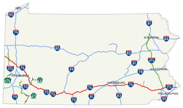
English: Map of Pennsylvania Turnpike; mainline highlighted in red and other sections green |
| Date | |
| Source | Own work; GIS data from PASDA/PennDOT PA State Roads 2012_01 |
| Author | User:O |
Licensing
[edit]
| I, the copyright holder of this work, release this work into the public domain. This applies worldwide. In some countries this may not be legally possible; if so: I grant anyone the right to use this work for any purpose, without any conditions, unless such conditions are required by law. |
File history
Click on a date/time to view the file as it appeared at that time.
| Date/Time | Thumbnail | Dimensions | User | Comment | |
|---|---|---|---|---|---|
| current | 00:02, 1 July 2016 | | 3,026 × 1,780 (319 KB) | Mr. Matté (talk | contribs) | User request to move PA 43 shield off of non-PTC-maintained road |
| 16:42, 10 May 2016 |  | 3,026 × 1,780 (446 KB) | Mr. Matté (talk | contribs) | Fix display order of city names | |
| 03:49, 10 May 2016 |  | 3,026 × 1,780 (446 KB) | Mr. Matté (talk | contribs) | Update PA 43 freeway; clean up multi-layered paths; add additional shields | |
| 05:40, 23 December 2012 |  | 3,425 × 2,031 (525 KB) | Rschen7754 (talk | contribs) | remove black box | |
| 05:28, 23 December 2012 |  | 3,425 × 2,031 (525 KB) | Rschen7754 (talk | contribs) | try this | |
| 05:26, 23 December 2012 |  | 1,000 × 575 (534 KB) | Fredddie (talk | contribs) | resize | |
| 02:14, 19 December 2012 |  | 3,425 × 2,031 (530 KB) | Dough4872 (talk | contribs) | Reverted to version as of 01:58, 19 December 2012 | |
| 02:13, 19 December 2012 |  | 3,425 × 2,031 (519 KB) | Dough4872 (talk | contribs) | fix | |
| 01:58, 19 December 2012 |  | 3,425 × 2,031 (530 KB) | Dough4872 (talk | contribs) | added shields, text | |
| 00:03, 19 October 2012 |  | 3,425 × 2,031 (279 KB) | O (talk | contribs) | {{Information |Description ={{en|1=Map of Pennsylvania Turnpike}} |Source ={{own}}; GIS data from [ftp://www.pasda.psu.edu/pub/pasda/padot/state/PaStateRoads2012_01.zip PASDA/PennDOT PA State Roads 2012_01] |Au... |
You cannot overwrite this file.
File usage on Commons
The following 7 pages use this file:
- User:Chumwa/OgreBot/Potential transport maps/2016 July 1-10
- User:Chumwa/OgreBot/Potential transport maps/2016 May 1-10
- User:Chumwa/OgreBot/Transport Maps/2016 July 1-10
- User:Chumwa/OgreBot/Transport Maps/2016 May 1-10
- User:Chumwa/OgreBot/Travel and communication maps/2016 July 1-10
- User:Chumwa/OgreBot/Travel and communication maps/2016 May 1-10
- Category:Pennsylvania Turnpike
File usage on other wikis
The following other wikis use this file:
- Usage on de.wikipedia.org
- Usage on es.wikipedia.org
- Usage on fr.wikipedia.org
- Usage on ja.wikipedia.org
- Usage on sv.wikipedia.org
- Usage on www.wikidata.org
- Usage on zh.wikipedia.org