File:Pennsylvania-counties-map.gif
Jump to navigation
Jump to search
Size of this preview: 800 × 478 pixels. Other resolutions: 320 × 191 pixels | 640 × 383 pixels | 833 × 498 pixels.
Original file (833 × 498 pixels, file size: 52 KB, MIME type: image/gif)
Captions
Captions
Add a one-line explanation of what this file represents

|
This locator map image could be re-created using vector graphics as an SVG file. This has several advantages; see Commons:Media for cleanup for more information. If an SVG form of this image is available, please upload it and afterwards replace this template with
{{vector version available|new image name}}.
It is recommended to name the SVG file “Pennsylvania-counties-map.svg”—then the template Vector version available (or Vva) does not need the new image name parameter. |
Summary
[edit]
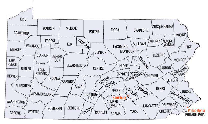
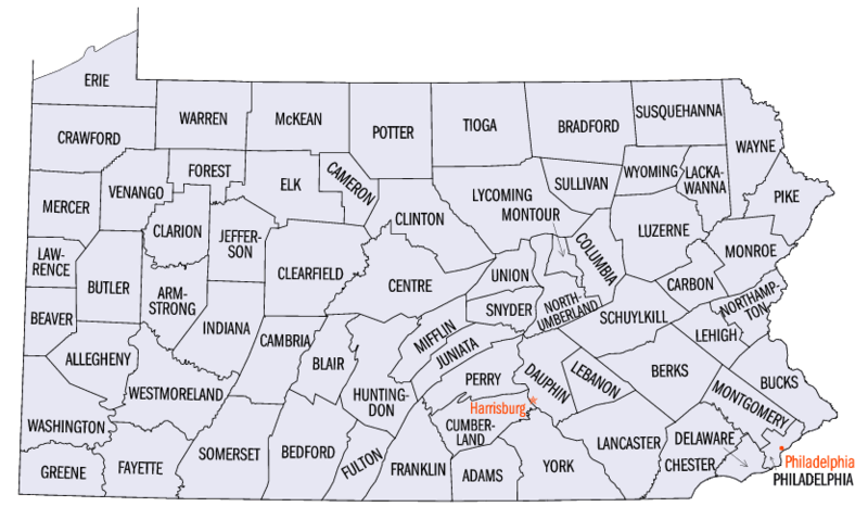
Map of Pennsylvania counties. Source: http://www.fedstats.gov/qf/maps/stout42.gif
Licensing
[edit]
| This file is licensed under the Creative Commons Attribution-Share Alike 3.0 Unported license. Subject to disclaimers. | ||
| ||
| This licensing tag was added to this file as part of the GFDL licensing update. |

|
Permission is granted to copy, distribute and/or modify this document under the terms of the GNU Free Documentation License, Version 1.2 or any later version published by the Free Software Foundation; with no Invariant Sections, no Front-Cover Texts, and no Back-Cover Texts. A copy of the license is included in the section entitled GNU Free Documentation License. Subject to disclaimers. |
Format
[edit]
File history
Click on a date/time to view the file as it appeared at that time.
| Date/Time | Thumbnail | Dimensions | User | Comment | |
|---|---|---|---|---|---|
| current | 05:29, 25 April 2010 | | 833 × 498 (52 KB) | AnonMoos (talk | contribs) | adjusting margins, fixing mimetype recognition |
| 13:12, 7 October 2006 | No thumbnail | (53 KB) | JosN (talk | contribs) | Map of Pennsylvania counties. |
You cannot overwrite this file.
File usage on Commons
There are no pages that use this file.
File usage on other wikis
The following other wikis use this file:
- Usage on ar.wikipedia.org
- Usage on cs.wikipedia.org
- Usage on cy.wikipedia.org
- Usage on el.wikipedia.org
- Usage on en.wikipedia.org
- Pennsylvania
- Index of Pennsylvania-related articles
- List of school districts in Pennsylvania
- User talk:Berniethomas68
- Portal:Pennsylvania
- Portal:Pennsylvania/Maps
- Wikipedia talk:WikiProject Pennsylvania/Archive 5
- Wikipedia talk:WikiProject Geography/Archive 6
- List of state and county courthouses in Pennsylvania
- Usage on es.wikipedia.org
- Usage on fa.wikipedia.org
- Usage on fr.wikipedia.org
- Usage on he.wikipedia.org
- Usage on hu.wikipedia.org
- Usage on it.wikipedia.org
- Usage on ja.wikipedia.org
- Usage on ko.wikipedia.org
- Usage on ml.wikipedia.org
- Usage on nds.wikipedia.org
- Usage on new.wikipedia.org
- Usage on nl.wikipedia.org
- Usage on no.wikipedia.org
- Usage on sq.wikipedia.org
- Usage on sr.wikipedia.org
- Usage on sv.wikipedia.org