File:Penang.gif
Original file (461 × 604 pixels, file size: 18 KB, MIME type: image/gif, looped, 7 frames, 11 s)
Captions
Captions
Summary
[edit]
| Description |
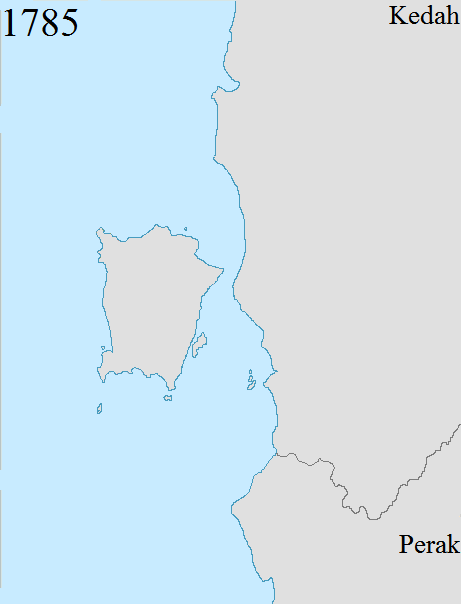
English: Territorial changes of the former British crown colony of Penang, now a state in Malaysia. Penang's present-day boundaries date back to 1874, when the final change to the boundaries was made following the Pangkor Treaty between the British Empire and Perak.
1786: The British East India Company acquired Penang Island from Kedah. 1800: The British East India Company acquired Province Wellesley from Kedah. At the time, Province Wellesley encompassed a thin strip of land south of the Perai River. 1831: The British East India Company expanded Province Wellesley northwards following a treaty with Siam, which had by then annexed Kedah.[1][2] Province Wellesley now included an area between the Muda River to the north and the Perai River to the south, with the Muda River serving as the boundary between Province Wellesley and Siam. 1859: The British East India Company and Siam signed another treaty to demarcate Province Wellesley's eastern boundaries with Siam.[3] 1874: Province Wellesley was expanded to include the southern watershed of the Kerian River, following the Pangkor Treaty between the British Empire and Perak.[4] Penang's boundaries have remained unchanged since then. |
| Date | |
| Source | Own work |
| Author | Dreamtrooper |
Licensing
[edit]
- You are free:
- to share – to copy, distribute and transmit the work
- to remix – to adapt the work
- Under the following conditions:
- attribution – You must give appropriate credit, provide a link to the license, and indicate if changes were made. You may do so in any reasonable manner, but not in any way that suggests the licensor endorses you or your use.
- share alike – If you remix, transform, or build upon the material, you must distribute your contributions under the same or compatible license as the original.
- ↑ Plan Of Prince Of Wales Island And Province Wellesley. www.nas.gov.sg. Retrieved on 2017-09-02.
- ↑ Map of Prince of Wales Island, or Pulo Penang and Province …. www.nas.gov.sg. Retrieved on 2017-09-02.
- ↑ Map Of Prince Of Wales Island And Province Wellesley, …. www.nas.gov.sg. Retrieved on 2017-09-02.
- ↑ Documents Archive | Empire in Asia (in en). www.fas.nus.edu.sg. Retrieved on 2017-05-01.
File history
Click on a date/time to view the file as it appeared at that time.
| Date/Time | Thumbnail | Dimensions | User | Comment | |
|---|---|---|---|---|---|
| current | 09:49, 2 September 2017 | | 461 × 604 (18 KB) | Vnonymous (talk | contribs) | User created page with UploadWizard |
You cannot overwrite this file.
File usage on Commons
There are no pages that use this file.
File usage on other wikis
The following other wikis use this file:
- Usage on en.wikipedia.org
- Usage on it.wikipedia.org
- Usage on ms.wikipedia.org
- Usage on sr.wikipedia.org