File:Pelourinho de Ladário - Portugal (7172366771).jpg

Original file (7,676 × 5,062 pixels, file size: 8.6 MB, MIME type: image/jpeg)
Captions
Captions
Summary
[edit].jpg&action=edit§ion=1)
| Description |
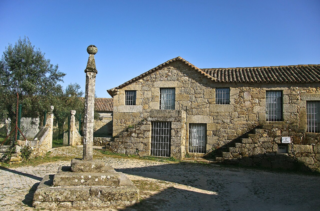
O antigo couto de Ladário foi concedido por D. Teresa e D. Afonso Henriques ao Convento de Águas Santas, da Ordem do Santo sepulcro, em 1125. Aqui estaria a origem do futuro concelho, constituído aquando da outorga de foral novo manuelino, em 1514. Foi extinto no século XIX, passano o Ladário a simples localidade da freguesia de São Miguel de Vila Boa, integrada no concelho de Sátão. Conserva ainda o antigo pelourinho, testemunho da sua perdida autonomia, e erguido na sequência do foral de D. Manuel, embora aparentemente em data muito mais tardia. O pelourinho levanta-se sobre uma singela plataforma de três degraus quadrangulares, de pedra toscamente aparelhada, bastante desgastados e desconjuntados. A coluna assenta directamente sobre o degrau superior, constituída por um fuste de arranque e topo quadrangular, e corpo oitavado através da chanfradura dos ângulos. Não existe capitel, mas apenas a curta secção quadrada do topo, onde morrem os chanfros, encimada por um ábaco quadrado e ligeiramente saliente, parcialmente mutilado. Aí pousa o remate, em pirâmide quadrada de faces lisas, com o vértice interceptado por uma esfera bem dimensionada. Tudo indica tratar-se de um monumento seiscentista, com singelo jogo volumétrico conseguido com a alternância de formas e sólidos muito simples, semelhante a tantos outros na região. SML <a href="http://www.igespar.pt/pt/patrimonio/pesquisa/geral/patrimonioimovel/detail/73989/" rel="nofollow">www.igespar.pt/pt/patrimonio/pesquisa/geral/patrimonioimo...</a> <a href="http://loc.alize.us/#/flickr:7172366771" rel="nofollow">See where this picture was taken.</a> <a href="https://www.flickr.com/groups/geotagging/discuss/72157594165549916/">[?]</a> |
| Date | |
| Source | Pelourinho de Ladário - Portugal |
| Author | Vitor Oliveira from Torres Vedras, PORTUGAL |
| Camera location | | View this and other nearby images on: OpenStreetMap |
|---|
.jpg¶ms=040.697807_N_-007.736798_E_globe:Earth_type:camera_source:Flickr_&language=en)
Licensing
[edit].jpg&action=edit§ion=2)
- You are free:
- to share – to copy, distribute and transmit the work
- to remix – to adapt the work
- Under the following conditions:
- attribution – You must give appropriate credit, provide a link to the license, and indicate if changes were made. You may do so in any reasonable manner, but not in any way that suggests the licensor endorses you or your use.
- share alike – If you remix, transform, or build upon the material, you must distribute your contributions under the same or compatible license as the original.
| This image was originally posted to Flickr by Portuguese_eyes at https://flickr.com/photos/21446942@N00/7172366771 (archive). It was reviewed on 8 May 2019 by FlickreviewR 2 and was confirmed to be licensed under the terms of the cc-by-sa-2.0. |
File history
Click on a date/time to view the file as it appeared at that time.
| Date/Time | Thumbnail | Dimensions | User | Comment | |
|---|---|---|---|---|---|
| current | 14:08, 29 May 2024 | | 7,676 × 5,062 (8.6 MB) | ReneeWrites (talk | contribs) | Removed watermark |
| 02:05, 8 May 2019 |  | 7,676 × 5,062 (8.58 MB) | Tm (talk | contribs) | Transferred from Flickr via #flickr2commons |
You cannot overwrite this file.
File usage on Commons
The following 2 pages use this file:
File usage on other wikis
The following other wikis use this file:
- Usage on eo.wikipedia.org
- Usage on pt.wikipedia.org
- Usage on www.wikidata.org
.jpg&oldid=896419047)