File:Peggys Cove Lighthouse, NS.jpg
Original file (4,000 × 2,000 pixels, file size: 598 KB, MIME type: image/jpeg)
Captions
Summary
[edit]DescriptionPeggys Cove Lighthouse, NS.jpg |
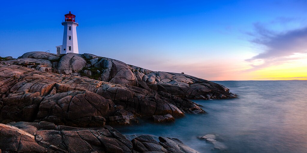
English: The iconic Peggy's Cove Lighthouse is a popular Nova Scotia Tourist destination.
Українська: Маяк Пеггіс-Пойнт, Нова Шотландія, Канада
|
This photo is of a cultural heritage site in Canada, number 2921
|
|
Date | |
Source | Own work |
Author | Shawn M. Kent |
Camera location | 44° 29′ 33.01″ N, 63° 55′ 06.87″ W | View this and other nearby images on: OpenStreetMap | 44.492503; -63.918575 |
---|
Licensing
[edit]- You are free:
- to share – to copy, distribute and transmit the work
- to remix – to adapt the work
- Under the following conditions:
- attribution – You must give appropriate credit, provide a link to the license, and indicate if changes were made. You may do so in any reasonable manner, but not in any way that suggests the licensor endorses you or your use.
This image was uploaded as part of Wiki Loves Monuments 2017.
Afrikaans ∙ Alemannisch ∙ العربية ∙ جازايرية ∙ azərbaycanca ∙ Bikol Central ∙ беларуская ∙ беларуская (тарашкевіца) ∙ български ∙ বাংলা ∙ brezhoneg ∙ bosanski ∙ català ∙ čeština ∙ Cymraeg ∙ dansk ∙ Deutsch ∙ Zazaki ∙ Ελληνικά ∙ English ∙ Esperanto ∙ español ∙ eesti ∙ euskara ∙ فارسی ∙ suomi ∙ français ∙ Frysk ∙ Gaeilge ∙ galego ∙ עברית ∙ हिन्दी ∙ hrvatski ∙ magyar ∙ հայերեն ∙ Bahasa Indonesia ∙ Ido ∙ italiano ∙ 日本語 ∙ ქართული ∙ 한국어 ∙ кыргызча ∙ Lëtzebuergesch ∙ latviešu ∙ Malagasy ∙ македонски ∙ മലയാളം ∙ Bahasa Melayu ∙ Malti ∙ norsk bokmål ∙ नेपाली ∙ Nederlands ∙ norsk nynorsk ∙ norsk ∙ polski ∙ português ∙ português do Brasil ∙ română ∙ русский ∙ sicilianu ∙ davvisámegiella ∙ slovenčina ∙ slovenščina ∙ shqip ∙ српски / srpski ∙ svenska ∙ ไทย ∙ Tagalog ∙ Türkçe ∙ українська ∙ اردو ∙ oʻzbekcha / ўзбекча ∙ Yorùbá ∙ 中文 ∙ 中文(中国大陆) ∙ 中文(简体) ∙ 中文(繁體) ∙ 中文(香港) ∙ 中文(臺灣) ∙ +/− |
This image was awarded with the 2nd prize in the national contest of Canada in Wiki Loves Monuments 2017 Other languages:
العربية | беларуская (тарашкевіца) | বাংলা | Deutsch | English | British English | español | français | hrvatski | italiano | ქართული | македонски | norsk (bokmål) | norsk (nynorsk) | português do Brasil | русский | slovenščina | svenska | українська | +/− |
File history
Click on a date/time to view the file as it appeared at that time.
Date/Time | Thumbnail | Dimensions | User | Comment | |
---|---|---|---|---|---|
current | 00:34, 22 September 2017 | 4,000 × 2,000 (598 KB) | Shawn M. Kent (talk | contribs) | User created page with UploadWizard |
You cannot overwrite this file.
File usage on Commons
The following 7 pages use this file:
File usage on other wikis
The following other wikis use this file:
- Usage on ca.wikimedia.org
- Usage on en.wikipedia.org
- Usage on it.wikivoyage.org
- Usage on ko.wikipedia.org
- Usage on ru.wikipedia.org
- Маяк Самбро
- Маяк Балаш-Пойнт
- Маяк Кейп-Форчу
- Маяк Форт-Пойнт (Новая Шотландия)
- Маяк Джорджес-Айленд
- Маяк Пеггис-Пойнт
- Маяк Грандик-Пойнт
- Маяк острова Кидстон
- Маяк Луисбурга
- Маяк Лоу-Пойнт
- Маяк Пойнт-Прим
- Маяк Кейп-д’Ор
- Маяк Дэвилс-Айленд
- Маяк Шафнер-Пойнт
- Маяк Сил-Айленд
- Маяк Виктория-Бич
- Шаблон:Маяки провинции Новая Шотландия
Metadata
This file contains additional information such as Exif metadata which may have been added by the digital camera, scanner, or software program used to create or digitize it. If the file has been modified from its original state, some details such as the timestamp may not fully reflect those of the original file. The timestamp is only as accurate as the clock in the camera, and it may be completely wrong.
Image title |
|
---|---|
Camera manufacturer | Canon |
Camera model | Canon EOS 5DS R |
Exposure time | 30/1 sec (30) |
F-number | f/8 |
ISO speed rating | 100 |
Date and time of data generation | 20:02, 6 August 2017 |
Lens focal length | 24 mm |
Latitude | 44° 29′ 33.01″ N |
Longitude | 63° 55′ 6.87″ W |
Altitude | 0.114 meters above sea level |
Label | Green |
Credit/Provider | Shawn M. Kent |
Short title |
|
City shown | Peggys Cove |
Horizontal resolution | 240 dpi |
Vertical resolution | 240 dpi |
Software used | Adobe Photoshop Lightroom 6.12 (Windows) |
File change date and time | 21:06, 21 September 2017 |
Exposure Program | Manual |
Exif version | 2.3 |
Date and time of digitizing | 20:02, 6 August 2017 |
APEX shutter speed | −4.906891 |
APEX aperture | 6 |
APEX exposure bias | 0 |
Maximum land aperture | 3 APEX (f/2.83) |
Metering mode | Pattern |
Flash | Flash did not fire, compulsory flash suppression |
Color space | sRGB |
Focal plane X resolution | 2,413.3333435059 |
Focal plane Y resolution | 2,413.3333435059 |
Focal plane resolution unit | 3 |
Custom image processing | Normal process |
Exposure mode | Manual exposure |
White balance | Manual white balance |
Scene capture type | Standard |
GPS tag version | 0.0.2.2 |
Serial number of camera | 162122000080 |
Lens used | EF24-70mm f/2.8L II USM |
Date metadata was last modified | 18:06, 21 September 2017 |
Unique ID of original document | 26C11DFBFDF29889A06FF2B5A047E344 |
Keywords |
|
Province or state shown | Nova Scotia |
Country shown | Canada |
Code for country shown | CA |
IIM version | 4 |
Structured data
Items portrayed in this file
depicts
44°29'33.011"N, 63°55'6.870"W
6 August 2017
30 second
24 millimetre
100
- Heritage properties in Canada with known IDs
- CC-BY-1.0
- Self-published work
- Images from Wiki Loves Monuments 2017
- Images from Wiki Loves Monuments 2017 in Canada
- Winners of Wiki Loves Monuments 2017 in Canada
- Nominated pictures for Wiki Loves Monuments International
- Uploaded via Campaign:wlm-ca
- Taken with Canon EF 24-70mm F2.8L II USM
- Taken with Canon EOS 5DS R
- Exposure time 30 sec