File:Pechenegs c.1030.bg.svg
Jump to navigation
Jump to search

Size of this PNG preview of this SVG file: 461 × 260 pixels. Other resolutions: 320 × 180 pixels | 640 × 361 pixels | 1,024 × 578 pixels | 1,280 × 722 pixels | 2,560 × 1,444 pixels.
Original file (SVG file, nominally 461 × 260 pixels, file size: 613 KB)
Captions
Captions
Add a one-line explanation of what this file represents
Summary
[edit]
| Description |
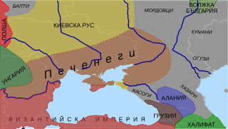
Български: Територия, контролирана от печенегите около 1030 г. English: Territorries of the Pechenegs c. 1030 |
| Source | Own work Image:Khazarfall1.png |
| Author | Nk |
| Other versions |
 |
Sources
[edit]
The map is based on the following sources:
Licensing
[edit]
| I, the copyright holder of this work, release this work into the public domain. This applies worldwide. In some countries this may not be legally possible; if so: I grant anyone the right to use this work for any purpose, without any conditions, unless such conditions are required by law. |
File history
Click on a date/time to view the file as it appeared at that time.
| Date/Time | Thumbnail | Dimensions | User | Comment | |
|---|---|---|---|---|---|
| current | 15:35, 11 February 2008 | | 461 × 260 (613 KB) | Nk (talk | contribs) | {{Information |Description='''bg:''' Територия, контролирана от печенегите около 1030 г.<br/>'''en:''' Territorries of the Pechenegs c. 1030 |Source=self-made |Date= |Author= Nk |Permission= |other_versio |
You cannot overwrite this file.
File usage on Commons
There are no pages that use this file.
File usage on other wikis
The following other wikis use this file: