File:Pecheli Sive Peking - Atlas Maior, vol 11, map 13 - Joan Blaeu, 1667 - BL 114.h(star).11.(13).jpg

Original file (4,000 × 3,400 pixels, file size: 2.03 MB, MIME type: image/jpeg)
Captions
Captions
Info
[edit]| Title |
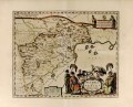
English: Beizhili or Beijing
Latina: Pecheli Sive Peking |
||||||||||||||||||||||||||
| Description |
English: Map published in Joan Blaeu's 1667 Atlas Maior |
||||||||||||||||||||||||||
| Date | |||||||||||||||||||||||||||
| Source |
Part of King George III's Topographical Collection. Donated to the nation by George IV. Please do not overwrite this file. Any cropped or modified version should be uploaded with a new name and linked in the "
|
||||||||||||||||||||||||||
| Creator |
|
||||||||||||||||||||||||||
| Permission (Reusing this file) |
|
||||||||||||||||||||||||||
| Georeferencing | If inappropriate please set warp_status = skip to hide. | ||||||||||||||||||||||||||
| Bibliographic data | |||||||||||||||||||||||||||
| Publication | |||||||||||||||||||||||||||
| Volume | 11 | ||||||||||||||||||||||||||
| Page(s) | 332 | ||||||||||||||||||||||||||
| Place of publication | Amsterdam | ||||||||||||||||||||||||||
| Publisher |
|
||||||||||||||||||||||||||
| Archival data | |||||||||||||||||||||||||||
| Collection | |||||||||||||||||||||||||||
| Accession number |
114.h*.11.(13) |
||||||||||||||||||||||||||
| Medium |
copper engraving print |
||||||||||||||||||||||||||
| Other versions |
|
||||||||||||||||||||||||||

.jpg)


_-_btv1b59630415.jpg)
.jpg)
.jpg)

.11.(13).jpg&action=edit§ion=1)
File history
Click on a date/time to view the file as it appeared at that time.
| Date/Time | Thumbnail | Dimensions | User | Comment | |
|---|---|---|---|---|---|
| current | 02:13, 21 May 2019 | | 4,000 × 3,400 (2.03 MB) | JhealdBot (talk | contribs) | JhealdBot(6) |
You cannot overwrite this file.
File usage on Commons
The following 7 pages use this file:
- File:"Pecheli, sive Peking, imperii Sinarum provincia prima." (22263939511).jpg
- File:Atlas Van der Hagen-KW1049B13 034-PECHELI SIVE PEKING IMPERII SINARVM PROVINCIA PRIMA.jpeg
- File:Figurative cartouche in a Beijing map by Joan Blaeu.jpg
- File:Novvs atlas Sinensis. LOC 2002625249-2.jpg
- File:Novvs atlas Sinensis. LOC 2002625249-2.tif
- File:Pecheli, sive Peking, Imperii Sinarum provincia prima, cum privilegio Sacrae Caesareae Majestatis & ordinum Belgicae Foederatae - btv1b525047297 (1 of 2).jpg
- File:Pecheli sive Peking imperii sinarum provincia prima - (tiré du P. Martini) - btv1b59630415.jpg
File usage on other wikis
The following other wikis use this file:
- Usage on www.wikidata.org
Metadata
.11.(13).jpg&oldid=742850728)
- 1660s maps of China
- Atlas Maior, Vol 11 (Asia) - Joan Blaeu, 1667 - BL 114.h(star).11
- Novus Atlas Sinensis
- Armillary spheres in art
- Compasses in art
- Geographers in art
- Maps of the Great Wall of China
- Maps with cartouches
- Maps with figures
- Animals on maps
- Old maps of Beijing
- Old maps of Tianjin
- Old maps of Hebei