File:Pawnee oli 2018175.jpg
Pawnee_oli_2018175.jpg (720 × 480 pixels, file size: 532 KB, MIME type: image/jpeg)
Captions
Captions
Summary
[edit]
| Description |
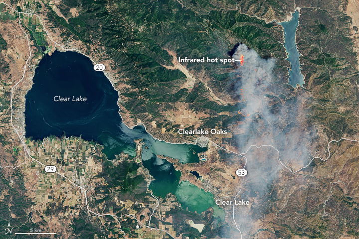
English: Summer 2018 is officially under way in the Northern Hemisphere, as is fire season. Some areas of Northern California have already been subjected to burning, including Lake County—about 100 miles northwest of Sacramento—where the Pawnee fire has destroyed structures and spurred evacuations.
The fire started on the evening of June 23, 2018. When satellites acquired these images on June 24, the fire had burned more than 1,500 acres and was producing thick smoke. The Operational Land Imager (OLI) on Landsat 8 acquired the first image at 11:50 a.m. Pacific Time on the 24th. The Moderate Resolution Imaging Spectroradiometer (MODIS) on NASA’s Aqua passed over a few hours later and acquired the wider view. Both images are natural color, overlaid with the infrared signature of actively burning fires. By June 26, the Pawnee fire had burned 11,500 acres and was 5 percent contained. Low humidity, erratic winds, and high temperatures helped the fire spread, according to CAL FIRE. The New York Times called it the “first explosive fire of the season.”Deutsch: Der Sommer 2018 hat auf der nördlichen Halbkugel gerade begonnen, und dasselbe gilt für die Waldbrandsaison in Kalifornien, wo einige Gebiete im Norden des Bundesstaates bereits von Feuern betroffen waren, darunter das etwa 160 km nordöstlich von Sacramento liegende Lake County, wo das Pawnee-Feuer Gebäude zerstörte und zu Evakuierungen führte.
Der Brand begann am Abend des 23. Juni 2018. Als die Satellitenaufnahme am 24. Juni angefertigt wurde, waren bereits mehr als 1500 Acre Raub der Flammen geworden, und das Feuer erzeugte dicke Rauchschwaden. Der Operational Land Imager (OLI) auf dem Landsat 8 fertigte das erste Bild am 24. Juni um 11:50 Uhr Pazifischer Sommerzeit an. Das Moderate Resolution Imaging Spectroradiometer (MODIS) auf dem Aqua-Satelliten der NASA überquerte die Gegend einige Stunden später und nahm das Region der weiteren Region auf. Beide Bilder sind in natürlichen Farben dargestellt, und die Infrarotsignatur der aktiv brennenden Feuer sind darüber gelegt. Bis zum 26. Juni verbrannte das Pawnee-Feuer 11.500 Acre Land und war zu fünf Prozent eingedämmt. Geringe Luftfeuchtigkeit, wechselnde Winde und hohe Temperaturen halfen bei der Ausbreitung des Feuers, sagte CAL FIRE. Die New York Times bezeichnete den brand als “erstes explosives Feuer der Saison.” |
| Date | |
| Source | https://earthobservatory.nasa.gov/IOTD/view.php?id=92343 |
| Author | NASA Earth Observatory images by Joshua Stevens, using Landsat data from the U.S. Geological Survey. Story by Kathryn Hansen. |
| Other versions |
 high resolution, unlabeled  wider views, unlabeled  wider view, labeled |
References and Related Reading
[edit]
- CAL FIRE (2018, June 26) Pawnee Fire Incident Information. Accessed June 26, 2018.
- National Public Radio (2018, June 26) Gov. Brown Declares State Of Emergency Over California Wildfires. Accessed June 26, 2018.
- The New York Times (2018, June 25) Fire Carves Path of Destruction Through Northern California. Accessed June 26, 2018.
- The Sacramento Bee (2018, June 26) Evacuations still in effect as crews fight to contain Pawnee Fire in Lake County. Accessed June 26, 2018.
Licensing
[edit]
| This file is in the public domain in the United States because it was solely created by NASA. NASA copyright policy states that "NASA material is not protected by copyright unless noted". (See Template:PD-USGov, NASA copyright policy page or JPL Image Use Policy.) | ||
 |
Warnings:
|
File history
Click on a date/time to view the file as it appeared at that time.
| Date/Time | Thumbnail | Dimensions | User | Comment | |
|---|---|---|---|---|---|
| current | 22:18, 28 June 2018 | | 720 × 480 (532 KB) | Matthiasb (talk | contribs) | {{Information |description ={{en|1=Summer 2018 is officially under way in the Northern Hemisphere, as is fire season. Some areas of Northern California have already been subjected to burning, including Lake County—about 100 miles northwest of Sacramento—where the Pawnee fire has destroyed structures and spurred evacuations. The fire started on the evening of June 23, 2018. When satellites acquired these images on June 24, the fire had burned more than 1,500 acres and was producing thick sm... |
You cannot overwrite this file.
File usage on Commons
The following 4 pages use this file: