File:Patagonia, 1855.jpg
Jump to navigation
Jump to search

Size of this preview: 487 × 599 pixels. Other resolutions: 195 × 240 pixels | 390 × 480 pixels | 624 × 768 pixels | 1,054 × 1,297 pixels.
Original file (1,054 × 1,297 pixels, file size: 513 KB, MIME type: image/jpeg)
Captions
Captions
Add a one-line explanation of what this file represents
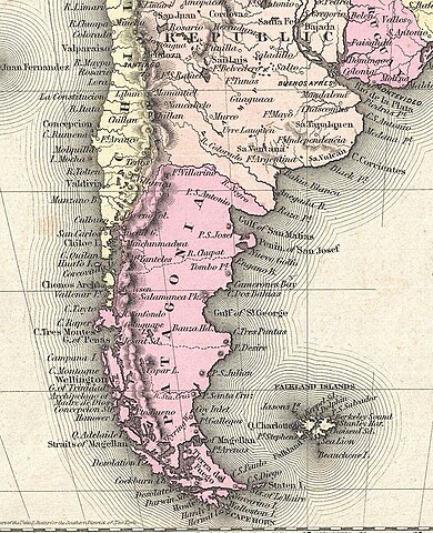
| J. H. Colton: South America.
( |
|||||||||||||||||||||
|---|---|---|---|---|---|---|---|---|---|---|---|---|---|---|---|---|---|---|---|---|---|
| Artist |
|
||||||||||||||||||||
| Title |
South America. |
||||||||||||||||||||
| Description |
English: An excellent first edition example of Colton's rare 1855 map South America. Covers the entire continent from the Caribbean to Tierra del Fuego and from the Pacific to the Atlantic. Includes the Galapagos, Juan Fernandez, Falkland and South Georgia island groups. Throughout the map Colton identifies various cities, towns, forts, rivers, rapids, fords, and an assortment of additional topographical details. Map is hand colored in pink, green, yellow and blue pastels to define national and regional boundaries. Surrounded by Colton's typical spiral motif border. Dated and copyrighted to J. H. Colton, 1855. Published as page no. 58 in volume 1 of the first edition of George Washington Colton's 1855 Atlas of the World . |
||||||||||||||||||||
| Date | 1855 (dated) | ||||||||||||||||||||
| Dimensions | height: 16 in (40.6 cm); width: 13 in (33 cm) | ||||||||||||||||||||
| Accession number |
Geographicus link: SouthAmerica-colton-1855 |
||||||||||||||||||||
| Source/Photographer |
Colton, G. W., Colton's Atlas of the World Illustrating Physical and Political Geography, Vol 1, New York, 1855 (First Edition).
|
||||||||||||||||||||
| Permission (Reusing this file) |
|
||||||||||||||||||||
| Other versions | |||||||||||||||||||||


File history
Click on a date/time to view the file as it appeared at that time.
| Date/Time | Thumbnail | Dimensions | User | Comment | |
|---|---|---|---|---|---|
| current | 01:54, 5 April 2024 | | 1,054 × 1,297 (513 KB) | Janitoalevic (talk | contribs) | File:1855 Colton Map of South America - Geographicus - SouthAmerica-colton-1855.jpg cropped 68 % horizontally, 68 % vertically using CropTool with precise mode. |
You cannot overwrite this file.
File usage on Commons
The following 3 pages use this file:
File usage on other wikis
The following other wikis use this file:
- Usage on en.wikipedia.org
- Usage on es.wikipedia.org