File:Partridge Point Seal Rock and Deep Partridge.png
Jump to navigation
Jump to search

Size of this preview: 643 × 600 pixels. Other resolutions: 257 × 240 pixels | 514 × 480 pixels | 823 × 768 pixels | 1,098 × 1,024 pixels | 2,195 × 2,048 pixels | 7,959 × 7,426 pixels.
Original file (7,959 × 7,426 pixels, file size: 5.22 MB, MIME type: image/png)
Captions
Captions
Add a one-line explanation of what this file represents
Summary
[edit]
| Description |
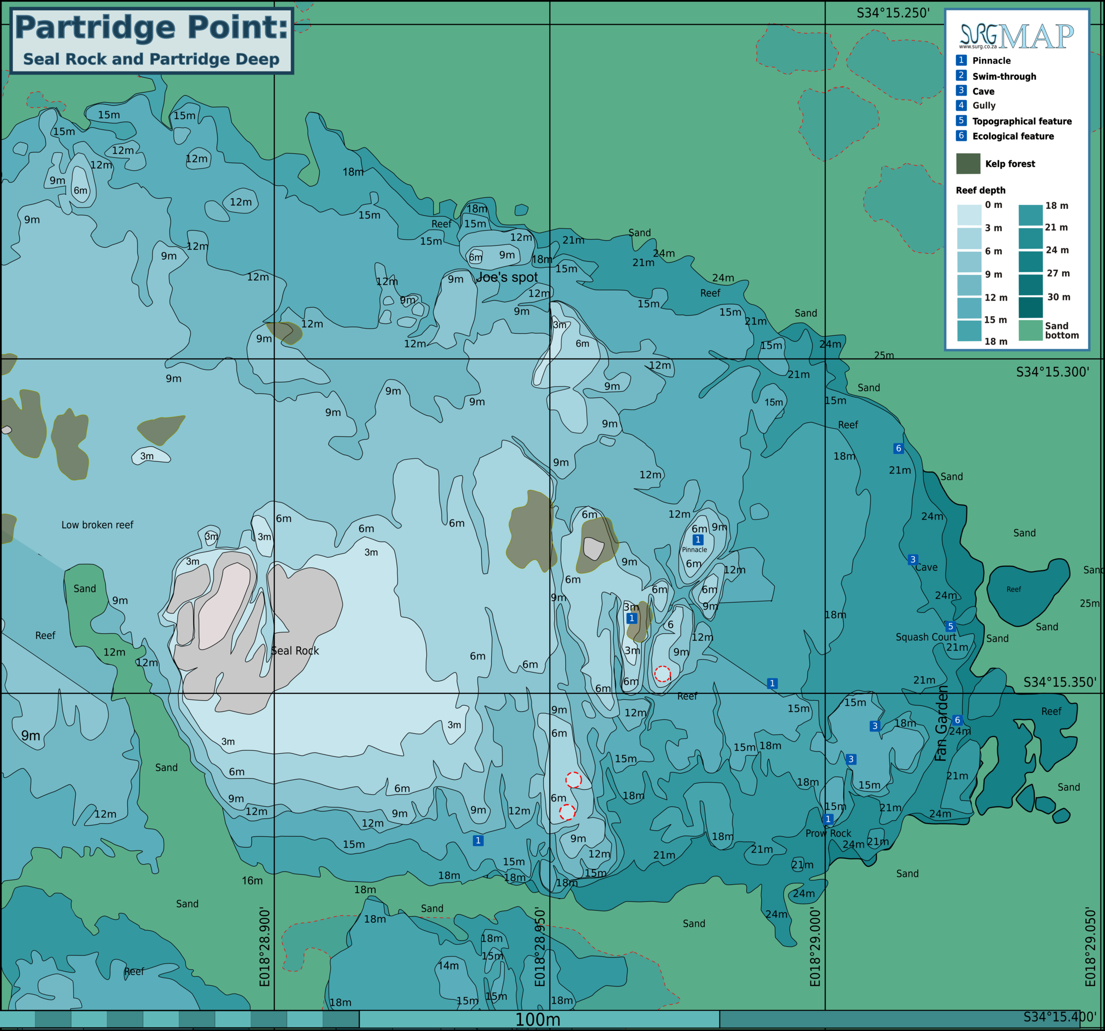
English: Detail of the reef at Partridge Point to the east of Seal Rock, Partridge Point, Cape Peninsula. |
| Date | |
| Source | Peter Southwood |
| Author | Peter Southwood |
| Other versions | SVG source |
Licensing
[edit]
Peter Southwood, the copyright holder of this work, hereby publishes it under the following license:
This file is licensed under the Creative Commons Attribution-Share Alike 3.0 Unported license.
Attribution: Peter Southwood
- You are free:
- to share – to copy, distribute and transmit the work
- to remix – to adapt the work
- Under the following conditions:
- attribution – You must give appropriate credit, provide a link to the license, and indicate if changes were made. You may do so in any reasonable manner, but not in any way that suggests the licensor endorses you or your use.
- share alike – If you remix, transform, or build upon the material, you must distribute your contributions under the same or compatible license as the original.
Original upload log
[edit]
| This file was imported from Wikivoyage WTS. |
The original description page was here. All following user names refer to wts.wikivoyage-old.
org:
- 2010-07-14 09:49 (WT-shared) Pbsouthwood[dead link] 2168×1513 (275127 bytes) {{Imagecredit|credit=Peter Southwood|captureDate=July 2010|location=Partridge Point, Cape Peninsula|source=Peter Southwood|caption=|descript (Import from wikitravel.org/shared)
- 2010-07-22 11:08 (WT-shared) Pbsouthwood[dead link] 2168×1513 (324283 bytes) (Import from wikitravel.org/shared)
- 2010-07-22 11:19 (WT-shared) Pbsouthwood[dead link] 2168×1513 (324283 bytes) (Import from wikitravel.org/shared)
- 2010-09-17 18:55 (WT-shared) Pbsouthwood[dead link] 2168×1627 (516421 bytes) (Import from wikitravel.org/shared)
- 2012-09-07 19:45 Pbsouthwood[dead link] 3000×2252 (722823 bytes) rm logo
File history
Click on a date/time to view the file as it appeared at that time.
| Date/Time | Thumbnail | Dimensions | User | Comment | |
|---|---|---|---|---|---|
| current | 09:48, 16 November 2021 | | 7,959 × 7,426 (5.22 MB) | Pbsouthwood (talk | contribs) | more contours, 15 and 18m |
| 08:25, 15 March 2020 |  | 7,959 × 7,426 (5.16 MB) | Pbsouthwood (talk | contribs) | Added some 15m contour and other details to northwest corner | |
| 12:12, 8 March 2020 |  | 7,959 × 7,240 (4.95 MB) | Pbsouthwood (talk | contribs) | Joe's spot and west 12m contour | |
| 16:44, 6 November 2016 |  | 7,941 × 7,223 (4.9 MB) | Pbsouthwood (talk | contribs) | added 3m and 6m contours | |
| 16:36, 25 September 2016 |  | 7,941 × 7,223 (4.62 MB) | Pbsouthwood (talk | contribs) | added extensive 9m contour | |
| 09:47, 26 June 2016 |  | 7,782 × 5,841 (3.76 MB) | Pbsouthwood (talk | contribs) | 24m contour, more sections of 21m and 18m contour to north | |
| 09:17, 22 June 2015 |  | 7,782 × 5,841 (3.38 MB) | Pbsouthwood (talk | contribs) | more 15m contour to the south | |
| 13:08, 25 May 2015 |  | 7,782 × 5,841 (3.07 MB) | Pbsouthwood (talk | contribs) | Update with partial 12m and 6m contours. | |
| 09:14, 22 December 2014 |  | 7,782 × 5,841 (2.75 MB) | Pbsouthwood (talk | contribs) | extended 18m contour | |
| 20:42, 16 July 2013 |  | 2,991 × 2,245 (819 KB) | Pbsouthwood (talk | contribs) | add partial contours for 18, 9, 6 and 3m |
You cannot overwrite this file.
File usage on Commons
The following 9 pages use this file:
- User:Chumwa/OgreBot/Transport Maps/2020 March 1-10
- User:Chumwa/OgreBot/Transport Maps/2020 March 11-20
- User:Chumwa/OgreBot/Transport Maps/2021 November 11-20
- User:Chumwa/OgreBot/Travel and communication maps/2016 June 21-30
- User:Chumwa/OgreBot/Travel and communication maps/2016 November 1-10
- User:Chumwa/OgreBot/Travel and communication maps/2016 September 21-30
- User:Chumwa/OgreBot/Travel and communication maps/2020 March 1-10
- User:Chumwa/OgreBot/Travel and communication maps/2020 March 11-20
- User:Chumwa/OgreBot/Travel and communication maps/2021 November 11-20
File usage on other wikis
The following other wikis use this file:
- Usage on en.wikivoyage.org
- Usage on www.wikidata.org