File:Parks Tanzania ru.svg
Jump to navigation
Jump to search

Size of this PNG preview of this SVG file: 580 × 600 pixels. Other resolutions: 232 × 240 pixels | 464 × 480 pixels | 743 × 768 pixels | 990 × 1,024 pixels | 1,980 × 2,048 pixels | 4,840 × 5,005 pixels.
Original file (SVG file, nominally 4,840 × 5,005 pixels, file size: 1.04 MB)
Captions
Captions
Add a one-line explanation of what this file represents
| Description |
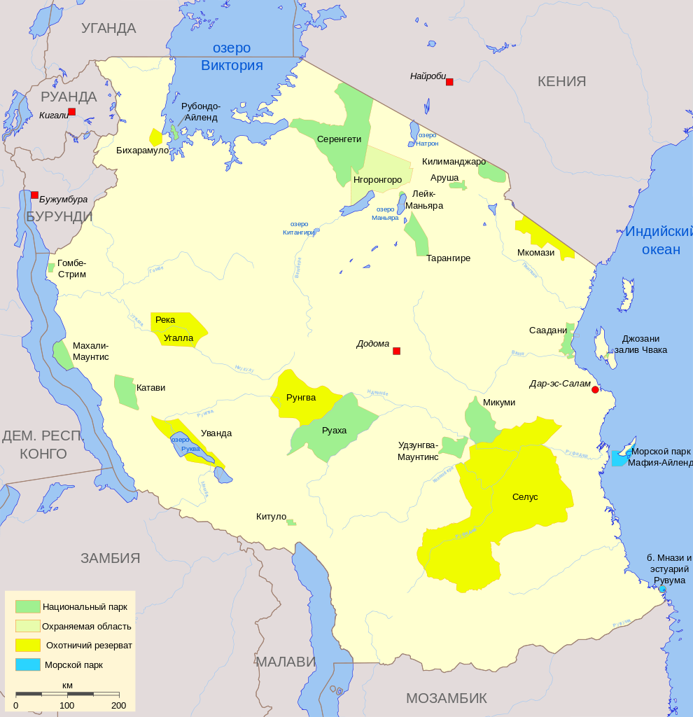
English: Map of National Parks and major protected areas in Tanzania.
Русский: Карта охраняемых природных территорий Танзании. |
| Date | (UTC) |
| Source | Parks Tanzania.svg |
| Author |
|
| SVG development |
I, the copyright holder of this work, hereby publish it under the following licenses:
| This file is licensed under the Creative Commons Attribution-Share Alike 3.0 Unported license. | ||
| ||
| This licensing tag was added to this file as part of the GFDL licensing update. |
The map has been created with the Generic Mapping Tools: https://www.generic-mapping-tools.org/ using one or more of these public-domain datasets for the relief:
|

|
Permission is granted to copy, distribute and/or modify this document under the terms of the GNU Free Documentation License, Version 1.2 or any later version published by the Free Software Foundation; with no Invariant Sections, no Front-Cover Texts, and no Back-Cover Texts. A copy of the license is included in the section entitled GNU Free Documentation License. |
You may select the license of your choice.
Original upload log
[edit]
This image is a derivative work of the following images:
- File:Parks Tanzania.svg licensed with Cc-by-sa-3.0-migrated, GFDL-GMT
- 2008-02-15T07:00:26Z Bamse 4840x5005 (1092088 Bytes)
- 2008-02-15T06:58:52Z Bamse 5988x8462 (1090998 Bytes)
- 2008-02-15T06:57:07Z Bamse 5988x8462 (1091370 Bytes)
- 2007-06-06T00:52:15Z Bamse 4842x5009 (1162660 Bytes) {{Information |Description=Map of National Parks and major protected areas in Tanzania. |Source=self-made |Date=29-05-2007 |Author= [[User:Bamse|Bamse]] }} {{GFDL-GMT}} {{Translation_possible}} [[Category:SVG maps of Tanzania]] [
- 2007-05-29T23:54:50Z Bamse 4842x5009 (1162655 Bytes) {{Information |Description=Map of National Parks and major protected areas in Tanzania. |Source=self-made |Date=29-05-2007 |Author= [[User:Bamse|Bamse]] }} {{GFDL-GMT}} [[Category:SVG maps of Tanzania]] [[Category:National parks
- 2007-05-29T09:57:22Z Bamse 4842x5009 (1082307 Bytes) {{Information |Description=Map of National Parks and major protected areas in Tanzania. |Source=self-made |Date=29-05-2007 |Author= [[User:Bamse|Bamse]] }} {{GFDL-GMT}} [[Category:SVG maps of Tanzania]] [[Category:National parks
- 2007-05-29T06:07:36Z Bamse 4842x5009 (1082307 Bytes) {{Information |Description=National Parks and major protected areas in Tanzania. |Source=own work |Date=29-05-2007 |Author=me, ~~~ |Permission= |other_versions= }} {{GFDL-GMT}} [[Category:SVG maps of Tanzania]] [[Category:Nationa
- 2007-05-29T06:01:50Z Bamse 5988x8462 (1080977 Bytes) {{Information |Description=Map of National Parks and major protected areas in Tanzania. |Source=self-made |Date=29-05-2007 |Author= [[User:Bamse|]] }} {{GFDL-GMT}}
Uploaded with derivativeFX
File history
Click on a date/time to view the file as it appeared at that time.
| Date/Time | Thumbnail | Dimensions | User | Comment | |
|---|---|---|---|---|---|
| current | 01:07, 7 March 2011 | | 4,840 × 5,005 (1.04 MB) | Chtototakoe (talk | contribs) | уточнение в переводе |
| 23:12, 6 March 2011 |  | 4,840 × 5,005 (1.04 MB) | Chtototakoe (talk | contribs) | уточнения в переводе | |
| 23:05, 6 March 2011 |  | 4,840 × 5,005 (1.04 MB) | Chtototakoe (talk | contribs) | {{Information |Description=Map of National Parks and major protected areas in Tanzania. Карта охраняемых природных территорий Танзании. |Source=*File:Parks_Tanzania.svg |Date=2011-03-06 23:02 (UTC) |Author=* |
You cannot overwrite this file.
File usage on Commons
The following page uses this file:
File usage on other wikis
The following other wikis use this file: