File:Parkend station goods yard, 1994 (geograph 4098206).jpg
Jump to navigation
Jump to search

Size of this preview: 394 × 599 pixels. Other resolutions: 158 × 240 pixels | 316 × 480 pixels | 505 × 768 pixels | 1,125 × 1,709 pixels.
Original file (1,125 × 1,709 pixels, file size: 1.21 MB, MIME type: image/jpeg)
Captions
Captions
Add a one-line explanation of what this file represents
Summary
[edit].jpg&action=edit§ion=1)
| Description |
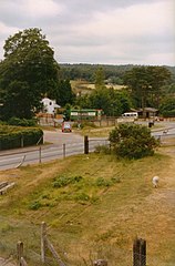
English: Parkend station goods yard, 1994 The tracks in the foreground were used to access a transhipment platform where stone was loaded onto rail wagons. This was last used in 1976, the station being left to quietly decline into weed strewn obscurity until the Dean Forest Railway restored it and returned traffic to this part of the line in 2005. In the background is the Fountain Inn, with a delivery in progress, and to the left of centre is my first car, a rather battered multicoloured Citroen 2cv! |
| Date | |
| Source | From geograph.org.uk |
| Author | John Winder |
| Permission (Reusing this file) |
Creative Commons Attribution Share-alike license 2.0 |
| Attribution (required by the license) | John Winder / Parkend station goods yard, 1994 / |
| Camera location | | View this and other nearby images on: OpenStreetMap |
|---|
.jpg¶ms=051.767560_N_-002.555981_E_globe:Earth_type:camera_source:geograph-osgb36(SO61730780)_heading:292.00&language=en)
| Object location | | View this and other nearby images on: OpenStreetMap |
|---|
.jpg¶ms=051.767920_N_-002.556850_E_globe:Earth_class:object_type:object_source:geograph-osgb36(SO61670784)_heading:292.00&language=en)
Licensing
[edit].jpg&action=edit§ion=2)

|
This image was taken from the Geograph project collection. See this photograph's page on the Geograph website for the photographer's contact details. The copyright on this image is owned by John Winder and is licensed for reuse under the Creative Commons Attribution-ShareAlike 2.0 license.
|
This file is licensed under the Creative Commons Attribution-Share Alike 2.0 Generic license.
Attribution: John Winder
- You are free:
- to share – to copy, distribute and transmit the work
- to remix – to adapt the work
- Under the following conditions:
- attribution – You must give appropriate credit, provide a link to the license, and indicate if changes were made. You may do so in any reasonable manner, but not in any way that suggests the licensor endorses you or your use.
- share alike – If you remix, transform, or build upon the material, you must distribute your contributions under the same or compatible license as the original.
File history
Click on a date/time to view the file as it appeared at that time.
| Date/Time | Thumbnail | Dimensions | User | Comment | |
|---|---|---|---|---|---|
| current | 21:56, 10 January 2021 | | 1,125 × 1,709 (1.21 MB) | Lamberhurst (talk | contribs) | Transferred from geograph.co.uk using [https://tools.wmflabs.org/geograph2commons/ geograph2commons] |
You cannot overwrite this file.
File usage on Commons
The following page uses this file:
.jpg&oldid=637955619)