File:Parisattacks.png
Jump to navigation
Jump to search
Size of this preview: 279 × 598 pixels. Other resolutions: 112 × 240 pixels | 224 × 480 pixels | 358 × 768 pixels | 477 × 1,024 pixels | 1,946 × 4,171 pixels.
Original file (1,946 × 4,171 pixels, file size: 12.78 MB, MIME type: image/png)
Captions
Captions
Add a one-line explanation of what this file represents

|
This map image could be re-created using vector graphics as an SVG file. This has several advantages; see Commons:Media for cleanup for more information. If an SVG form of this image is available, please upload it and afterwards replace this template with
{{vector version available|new image name}}.
It is recommended to name the SVG file “Parisattacks.svg”—then the template Vector version available (or Vva) does not need the new image name parameter. |
| Description |
Français : Carte de novembre 2015, attaques parisiennes coordonnées.
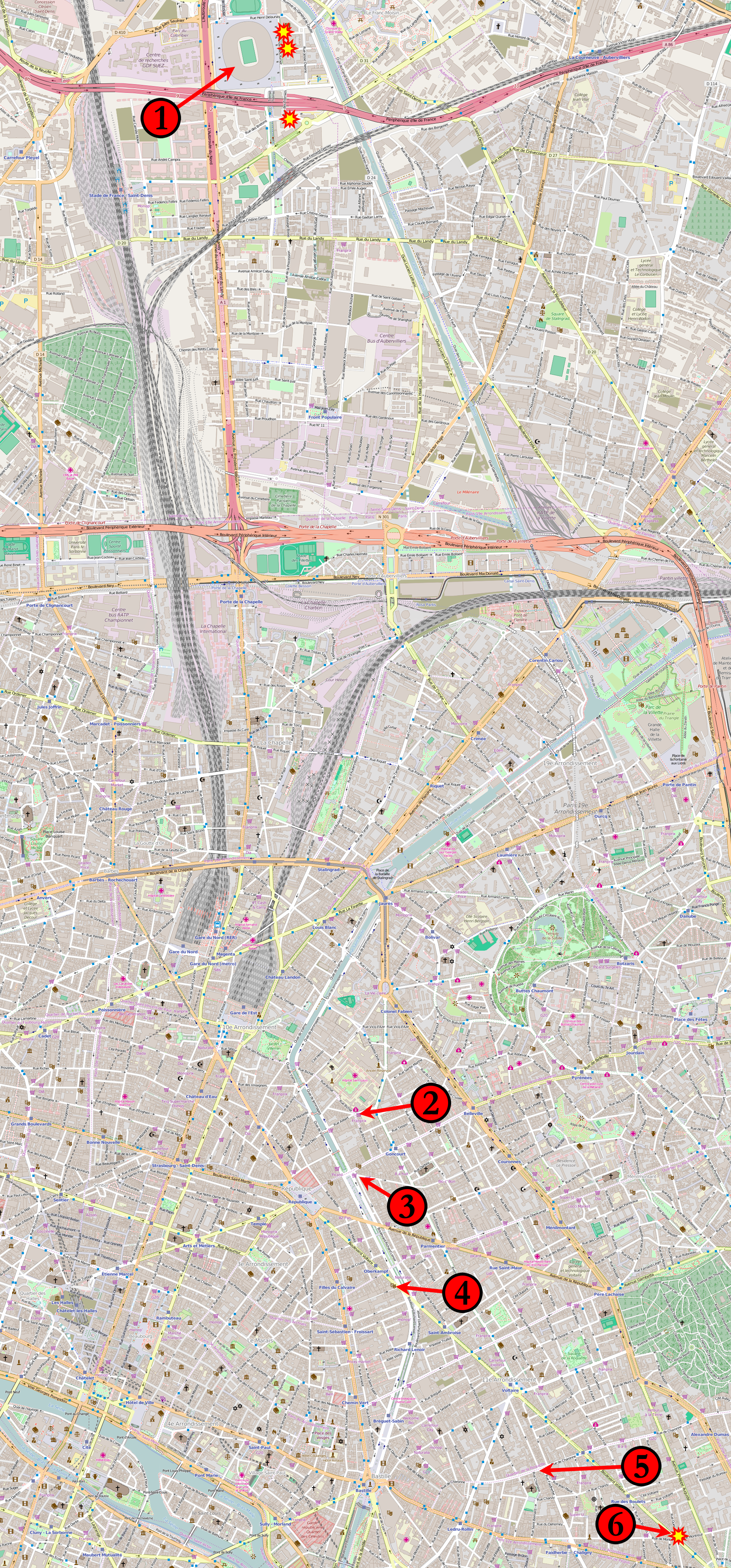
(1) 21 h 20, 21 h 30, 21 h 53 : Stade de France à Saint-Denis. (2) 21 h 25 : Le Carillon, croisement des rues Alibert et Bichat et Le petit Cambodge, rue Alibert. (3) 21 h 32 : Café Bonne Bière, rue du Faubourg-du-Temple et Casa Nostra, rue de la Fontaine-au-Roi. (4) 21 h 40 : Le Bataclan, bar-concert, boulevard Voltaire. (5) 21 h 36 : La Belle Équipe, rue de Charonne. (6) 21 h 46 : Comptoir Voltaire, boulevard Voltaire. Étoiles : Attaques suicide à la ceinture explosive autour du Stade de France et du restaurant Comptoir Voltaire. Les kamikazes du Bataclan ne sont pas identifiés individuellement. English: Map of the November 2015 Paris attacks in relation to each other.
(1) 21:20, 21:30, 21:53 : Stade de France in Saint-Denis. (2) 21:25 : Le Carillon, junction of rue Bichat and rue Alibert and Le petit Cambodge, rue Alibert. (3) 21:32 : Café Bonne Bière, rue du Faubourg-du-Temple and Casa Nostra, rue de la Fontaine-au-Roi. (4) 21:40 : Le Bataclan theatre. (5) 21:36 : La Belle Équipe, rue de Charonne. (6) 21:46 : Comptoir Voltaire, boulevard Voltaire. Stars: Individual suicide bombings around the Stade de France and the Comptoir Voltaire restaurant. The suicide bombings at Le Bataclan are not individually distinguished. Čeština: Mapa míst teroristických útoků v Paříži:
1) Stade de France 2) křížení ulic Rue Bichat a Rue Alibert 3) Casa Nostra, Rue de la Fontaine-au-Roi 4) koncertní sál Bataclan 5) Rue de Charonne 6) Comptoir Voltaire, boulevard Voltaire. Русский: Карта мест террористических актов в Париже 13 ноября 2015 года: 1) «Стад де Франс» 2) пересечение улиц Rue Bichat и Rue Alibert 3) Casa Nostra, Rue de la Fontaine 4) концертный зал театра «Батаклан» 5) улица Rue de Charonne |
|||
| Date | ||||
| Source | Base map from OpenStreetMap | |||
| Author | Veggies | |||
| Permission (Reusing this file) |
This file is licensed under the Creative Commons Attribution-Share Alike 2.0 Generic license.
|
|||
| Other versions |
 |
File history
Click on a date/time to view the file as it appeared at that time.
| Date/Time | Thumbnail | Dimensions | User | Comment | |
|---|---|---|---|---|---|
| current | 11:15, 20 November 2015 | | 1,946 × 4,171 (12.78 MB) | Veggies (talk | contribs) | Returning to original size. Map is unreadable in reduced version. |
| 20:11, 19 November 2015 |  | 933 × 2,000 (3.85 MB) | Flappiefh (talk | contribs) | Reduced the size of the picture to relieve Wikimedia servers. | |
| 18:27, 18 November 2015 |  | 1,946 × 4,171 (14.59 MB) | Flappiefh (talk | contribs) | Added a number next to the kamikaze attack near the Comptoir Voltaire. | |
| 04:18, 15 November 2015 |  | 1,946 × 4,171 (12.79 MB) | Veggies (talk | contribs) | Added the locations for the individual suicide bombings around the stadium and at the Comptoir Voltaire restaurant on Boulevard Voltaire. | |
| 13:15, 14 November 2015 |  | 1,946 × 4,171 (12.77 MB) | Veggies (talk | contribs) | Changed numbers to match order of attacks, added Casa Nostra location | |
| 05:17, 14 November 2015 |  | 1,946 × 4,171 (12.78 MB) | Veggies (talk | contribs) | {{Information |Description ={{en|1=Map of the November 2015 Paris attacks in relation to each other.}} |Source =Base map from [https://www.openstreetmap.org OpenStreetMap] |Author =Veggies |Date =2014-11-14... |
You cannot overwrite this file.
File usage on Commons
The following 3 pages use this file:
File usage on other wikis
The following other wikis use this file:
- Usage on ar.wikipedia.org
- Usage on arz.wikipedia.org
- Usage on as.wikipedia.org
- Usage on az.wikipedia.org
- Usage on bat-smg.wikipedia.org
- Usage on bg.wikipedia.org
- Usage on bn.wikipedia.org
- Usage on br.wikipedia.org
- Usage on bs.wikipedia.org
- Usage on ca.wikipedia.org
- Usage on ca.wikinews.org
- Usage on cs.wikipedia.org
- Usage on cs.wikinews.org
- Usage on da.wikipedia.org
- Usage on diq.wikipedia.org
- Usage on el.wikipedia.org
- Usage on en.wikipedia.org
- Usage on eo.wikipedia.org
- Usage on eo.wikinews.org
- Usage on es.wikipedia.org
- Usage on et.wikipedia.org
- Usage on eu.wikipedia.org
- Usage on fa.wikipedia.org
- Usage on fi.wikipedia.org
- Usage on fo.wikipedia.org
- Usage on fr.wikipedia.org
- Usage on fr.wikinews.org
- Usage on ga.wikipedia.org
- Usage on glk.wikipedia.org
- Usage on gl.wikipedia.org
- Usage on he.wikipedia.org
- Usage on hi.wikipedia.org
- Usage on hr.wikipedia.org
- Usage on hu.wikipedia.org
- Usage on hy.wikipedia.org
- Usage on id.wikipedia.org
- Usage on io.wikipedia.org
- Usage on is.wikipedia.org
- Usage on it.wikinews.org
- Usage on ja.wikipedia.org
- Usage on kk.wikipedia.org
- Usage on ku.wikipedia.org
- Usage on la.wikipedia.org
View more global usage of this file.