File:Paraguay. LOC 84691716.jpg
Jump to navigation
Jump to search
Size of this preview: 800 × 600 pixels. Other resolutions: 320 × 240 pixels | 640 × 480 pixels | 1,024 × 767 pixels | 1,280 × 959 pixels | 2,560 × 1,918 pixels | 6,508 × 4,877 pixels.
Original file (6,508 × 4,877 pixels, file size: 4.56 MB, MIME type: image/jpeg)
Captions
Captions
Add a one-line explanation of what this file represents
Summary
[edit]| Description |
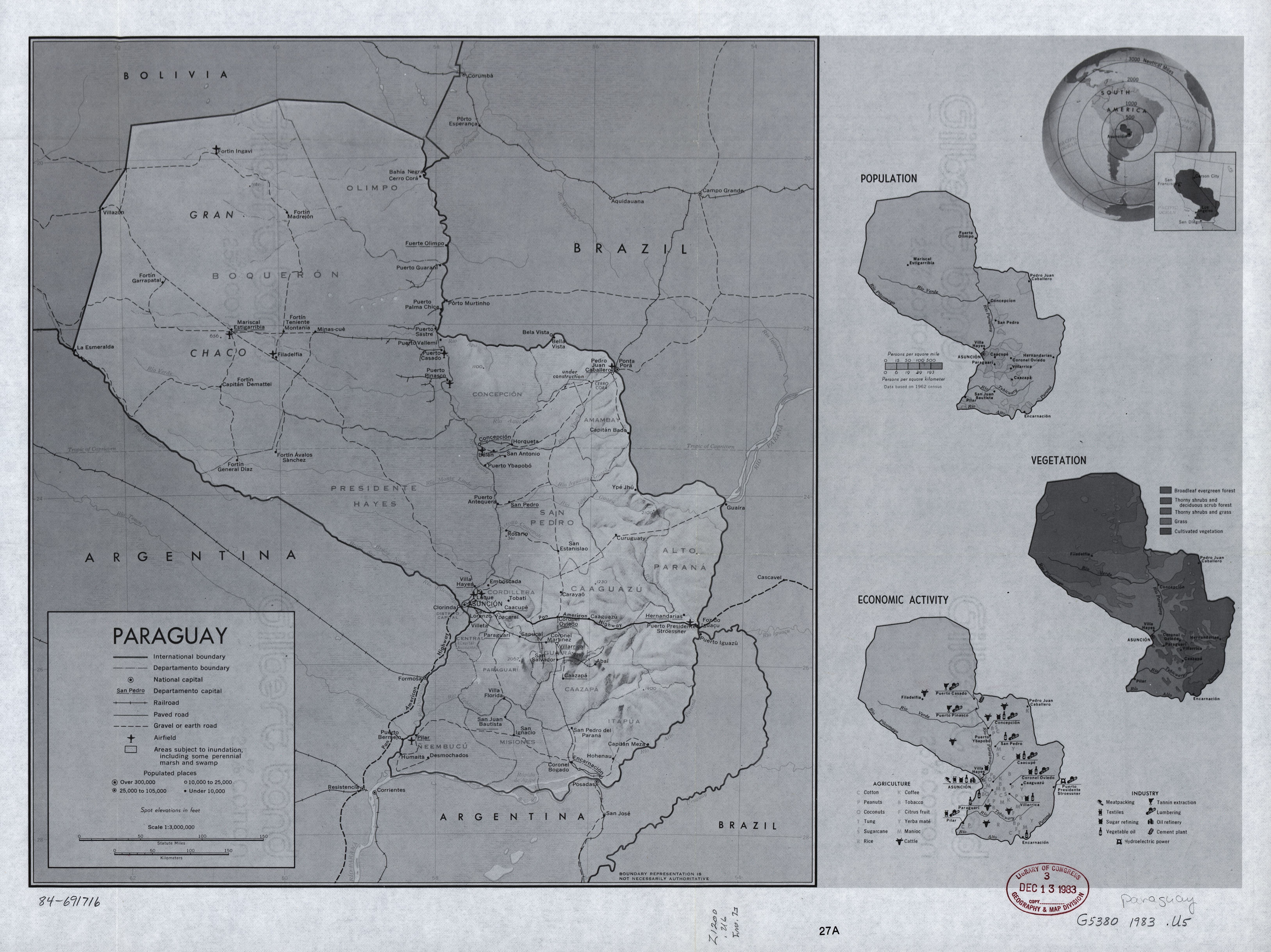
English: Relief shown by shading and spot heights. Includes location map with radial distances, comparative map, and subject maps of "Population," "Vegetation," and "Economic activity." In lower right margin: 27A. Available also through the Library of Congress Web site as a raster image. |
||
| Title | Paraguay. | ||
| Shelf ID | G5380 1983 .U5 | ||
| Date | |||
| Source | https://www.loc.gov/item/84691716/ | ||
| Author | United States. Central Intelligence Agency | ||
| Permission (Reusing this file) |
|
||
| Other versions |
|
||
| Location | Paraguay | ||
| Part of | American Memory · General Maps · Catalog · Geography And Map Division | ||
| Subject | Paraguay · Maps · Phytogeography · Economic Conditions · Population |


Licensing
[edit]
| This image is a work of a Central Intelligence Agency employee, taken or made as part of that person's official duties. As a Work of the United States Government, this image or media is in the public domain in the United States.
|

|
File history
Click on a date/time to view the file as it appeared at that time.
| Date/Time | Thumbnail | Dimensions | User | Comment | |
|---|---|---|---|---|---|
| current | 04:11, 18 May 2018 | | 6,508 × 4,877 (4.56 MB) | Fæ (talk | contribs) | LOC Maps https://www.loc.gov/item/84691716/ #10547 |
You cannot overwrite this file.
File usage on Commons
The following page uses this file: