File:Pante Macassar posto administrativo.png
Jump to navigation
Jump to search

Size of this preview: 741 × 600 pixels. Other resolutions: 297 × 240 pixels | 593 × 480 pixels | 1,008 × 816 pixels.
Original file (1,008 × 816 pixels, file size: 296 KB, MIME type: image/png)
Captions
Captions
Add a one-line explanation of what this file represents
| Description |
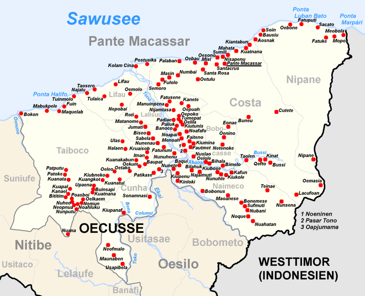
Deutsch: Subdistrikt Pante Macassar, Distrikt Oecusse, Osttimor English: Subdistrict of Pante Macassar, district Oecusse, East Timor |
| Date | (UTC) |
| Source | |
| Author |
| This is a retouched picture, which means that it has been digitally altered from its original version. Modifications: Adminitrative names, cities and rivers Pante Macassar of Nitibe added. The original can be viewed here: Administrative map of the Oecussi district of East Timor.png:
|
I, the copyright holder of this work, hereby publish it under the following license:
This file is licensed under the Creative Commons Attribution-Share Alike 2.5 Generic license.
- You are free:
- to share – to copy, distribute and transmit the work
- to remix – to adapt the work
- Under the following conditions:
- attribution – You must give appropriate credit, provide a link to the license, and indicate if changes were made. You may do so in any reasonable manner, but not in any way that suggests the licensor endorses you or your use.
- share alike – If you remix, transform, or build upon the material, you must distribute your contributions under the same or compatible license as the original.
Original upload log
[edit]
This image is a derivative work of the following images:
- File:Administrative_map_of_the_Oecussi_district_of_East_Timor.png licensed with Cc-by-sa-2.5
- 2010-06-03T07:46:45Z Chumwa 1855x1345 (152369 Bytes) Fatu Sinai wieder mit in den Kartenausschnitt aufgenommen
- 2010-06-03T07:39:20Z Chumwa 1702x1345 (155027 Bytes) Flüsse hinzugefügt
- 2009-09-22T05:16:22Z Chumwa 1861x1345 (115296 Bytes) Fatu Sinai mit in den Kartenausschnitt aufgenommen
- 2009-09-19T05:59:03Z Chumwa 1702x1345 (110884 Bytes) {{Information |Description= {{ de }} Verwaltungskarte des Distrikts Oecussi in Osttimor {{ en }} Administrative map of the Oecussi district of East Timor |Source=Self made, using informations from the[http://websig.civil.ist.
Uploaded with derivativeFX
File history
Click on a date/time to view the file as it appeared at that time.
| Date/Time | Thumbnail | Dimensions | User | Comment | |
|---|---|---|---|---|---|
| current | 10:43, 6 July 2010 | | 1,008 × 816 (296 KB) | J. Patrick Fischer (talk | contribs) | {{Information |Description={{ de }} Subdistrikt Pante Macassar, Distrikt Oecusse, Osttimor {{ en }} Subdistrict of Pante Macassar, district Oecusse, East Timor |Source=*File:Administrative_map_of_the_Oecussi_district_of_East_Timor.png |Date=2010-07 |
You cannot overwrite this file.
File usage on Commons
The following 3 pages use this file:
File usage on other wikis
The following other wikis use this file:
- Usage on de.wikipedia.org
- Usage on en.wikipedia.org
- Usage on es.wikipedia.org
- Usage on id.wikipedia.org
- Usage on it.wikipedia.org
- Usage on ja.wikipedia.org
- Usage on ms.wikipedia.org
- Usage on nl.wikipedia.org
- Usage on no.wikipedia.org
- Usage on pl.wikipedia.org
- Usage on pt.wikipedia.org
- Usage on sv.wikipedia.org
- Usage on tet.wikipedia.org
- Usage on ur.wikipedia.org
- Usage on war.wikipedia.org
- Usage on www.wikidata.org