File:Panoramic view of Harbor Island, between 1912 and 1916.jpg
Jump to navigation
Jump to search

Size of this preview: 800 × 335 pixels. Other resolutions: 320 × 134 pixels | 640 × 268 pixels | 1,279 × 535 pixels.
Original file (1,279 × 535 pixels, file size: 196 KB, MIME type: image/jpeg)
Captions
Captions
Add a one-line explanation of what this file represents
Summary
[edit]
| Description |
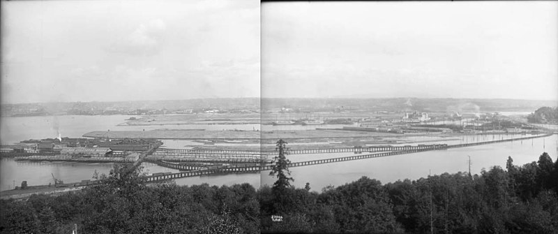
English: Panoramic view of Harbor Island and (nearer the camera) what would later be completely filled in and become Industrial District West, Seattle, Washington, U.S. Photo is between 1912 and 1916. Point of view is from West Seattle. In the middle distance, Colman Creosoting Works can be seen at left (north); that is part of the site of present-day (2022) Jack Block Park. The Fisher flour mill and its sign can be seen on the West Waterway, in the center of the photo. A shipyard and other industries are located nearby. |
|||||
| Date | between 1912 and 1916 | |||||
| Source | File:Panoramic view of Harbor Island, between 1912 and 1917 (MOHAI 5199).jpg, File:Panoramic view of Harbor Island, between 1912 and 1916 (MOHAI 5200).jpg | |||||
| Author | Photos: Webster & Stevens; stitching: Joe Mabel | |||||
| Permission (Reusing this file) |
Photos:
Stitching: Joe Mabel, the copyright holder of this work, hereby publishes it under the following license:
Attribution to Joe Mabel for the stitching is appreciated, but not required. |
|||||
| Other versions |
This file was derived from: Panoramic view of Harbor Island, between 1912 and 1917 (MOHAI 5199).jpg |
.jpg)
.jpg)
File history
Click on a date/time to view the file as it appeared at that time.
| Date/Time | Thumbnail | Dimensions | User | Comment | |
|---|---|---|---|---|---|
| current | 04:55, 14 January 2022 | | 1,279 × 535 (196 KB) | Jmabel (talk | contribs) | {{Information |Description={{en|Panoramic view of Harbor Island and (nearer the camera) what would later be completely filled in and become Industrial District West, Seattle, Washington, U.S. Photo is between 1912 and 1916. Point of view is from West Seattle. In the middle distance, Colman Creosoting Works can be seen at left (north); that is part of the site of present-day (2022) Jack Block Park. The Fisher flour mill and its sign can be seen on the West Waterway, in the center of the photo.... |
You cannot overwrite this file.
File usage on Commons
There are no pages that use this file.