File:Panoramic View of East Kabul City.jpg
Jump to navigation
Jump to search

Size of this preview: 800 × 251 pixels. Other resolutions: 320 × 100 pixels | 640 × 201 pixels | 1,024 × 321 pixels | 1,280 × 402 pixels | 4,434 × 1,392 pixels.
Original file (4,434 × 1,392 pixels, file size: 905 KB, MIME type: image/jpeg)
Captions
Captions
Add a one-line explanation of what this file represents
Summary
[edit]
| Description |
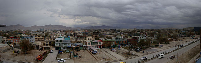
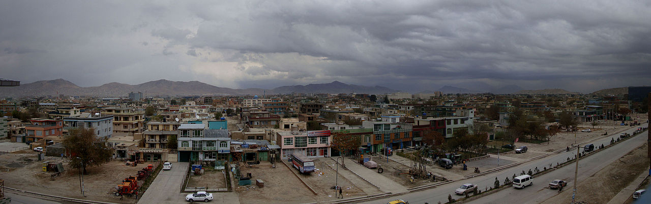
English: This is a panoramic view of Kabul City showing the east of the city Kair Khana District, heading to the south will lead to KAIA.
فارسی: عکسی پانوراما از بخش شرقی شهر کابل به نام خیر خانه مینه که از سمت جنوب به فرودگاه بینالمللی کابل راه دارد. |
| Date | Taken on 11 February 2009 |
| Source | Self-photographed |
| Author | Siar Fisher |
| Other versions |
Derivative works of this file: Kabul banner.jpg  .jpg) |
Licensing
[edit]
I, the copyright holder of this work, hereby publish it under the following licenses:
This file is licensed under the Creative Commons Attribution-Share Alike 3.0 Unported license.
- You are free:
- to share – to copy, distribute and transmit the work
- to remix – to adapt the work
- Under the following conditions:
- attribution – You must give appropriate credit, provide a link to the license, and indicate if changes were made. You may do so in any reasonable manner, but not in any way that suggests the licensor endorses you or your use.
- share alike – If you remix, transform, or build upon the material, you must distribute your contributions under the same or compatible license as the original.

|
Permission is granted to copy, distribute and/or modify this document under the terms of the GNU Free Documentation License, Version 1.2 or any later version published by the Free Software Foundation; with no Invariant Sections, no Front-Cover Texts, and no Back-Cover Texts. A copy of the license is included in the section entitled GNU Free Documentation License. |
You may select the license of your choice.
File history
Click on a date/time to view the file as it appeared at that time.
| Date/Time | Thumbnail | Dimensions | User | Comment | |
|---|---|---|---|---|---|
| current | 09:13, 25 September 2010 | 4,434 × 1,392 (905 KB) | SiarFisher (talk | contribs) | {{Information |Description={{en|1=This is a panoramic view of en:Kabul City showing the east of the city ''Kair Khana District'', heading to the south will lead to en:Kabul International Airport (KAIA).}} {{fa|1= عکسی پانوراما از |
You cannot overwrite this file.
File usage on Commons
The following 4 pages use this file:
File usage on other wikis
The following other wikis use this file:
- Usage on eo.wikipedia.org
- Usage on es.wikinews.org
- Usage on fa.wikipedia.org
- Usage on he.wikipedia.org
- Usage on incubator.wikimedia.org
- Usage on it.wikipedia.org