File:Panke-buchhgrabenAugust-200.png
Jump to navigation
Jump to search

Size of this preview: 450 × 600 pixels. Other resolutions: 180 × 240 pixels | 360 × 480 pixels | 576 × 768 pixels | 1,200 × 1,600 pixels.
Original file (1,200 × 1,600 pixels, file size: 1.5 MB, MIME type: image/png)
Captions
Captions
Add a one-line explanation of what this file represents
Summary
[edit]
| Description |
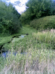
Deutsch: Zufluss des Buchholzer Graben zur Panke. Beim Bau des Berliner Eisenbahnaußenrings wurden Gräben der Rieselfelder nördlich des notwendigen Eisenbahndammes zusammengefasst und über diesen Graben zur Panke abgeleitet. |
| Date | |
| Source | Own work |
| Author | Boonekamp |
| Camera location | | View this and other nearby images on: OpenStreetMap |
|---|
Licensing
[edit]
| I, the copyright holder of this work, release this work into the public domain. This applies worldwide. In some countries this may not be legally possible; if so: I grant anyone the right to use this work for any purpose, without any conditions, unless such conditions are required by law. |
File history
Click on a date/time to view the file as it appeared at that time.
| Date/Time | Thumbnail | Dimensions | User | Comment | |
|---|---|---|---|---|---|
| current | 16:44, 8 December 2008 | | 1,200 × 1,600 (1.5 MB) | Boonekamp (talk | contribs) | {{Information |Description={{de|1=Zufluss des Buchholzer Graben zur Panke. Beim Bau des Berliner Eisenbahnaußenrings wurden Gräben der Rieselfelder nördlich des notwendigen Eisenbahndammes zusammengefasst und über diesen Graben zur Panke abgeleitet.}} |
You cannot overwrite this file.
File usage on Commons
The following page uses this file: