File:PangeaUltimaRoughEstimation.png
Jump to navigation
Jump to search

Size of this preview: 680 × 599 pixels. Other resolutions: 272 × 240 pixels | 545 × 480 pixels | 776 × 684 pixels.
Original file (776 × 684 pixels, file size: 16 KB, MIME type: image/png)
Captions
Captions
Add a one-line explanation of what this file represents

|
This map image could be re-created using vector graphics as an SVG file. This has several advantages; see Commons:Media for cleanup for more information. If an SVG form of this image is available, please upload it and afterwards replace this template with
{{vector version available|new image name}}.
It is recommended to name the SVG file “PangeaUltimaRoughEstimation.svg”—then the template Vector version available (or Vva) does not need the new image name parameter. |
Summary
[edit]| Description |
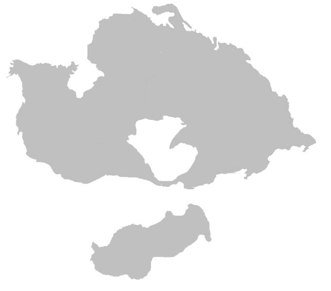
English: Estimation and appoximation of Pangea Ultima, based on information at [1]; not for scientific use. |
| Date | |
| Source | PangeaUltimaRoughEstimation.jpg |
| Author | Pokéfan95 |
| Other versions |
|
| Additional information | Image converted to PNG using image.online-convert.com. |


Original upload log
[edit]
This image is a derivative work of the following images:
- File:BlankMap-World-noborders.png licensed with PD-user-en, PD-user-w
- 2006-06-19T22:45:24Z Sanbec 1357x628 (19458 Bytes) Thumbnail generation
Licensing
[edit]
I, the copyright holder of this work, hereby publish it under the following license:
| This file is made available under the Creative Commons CC0 1.0 Universal Public Domain Dedication. | |
| The person who associated a work with this deed has dedicated the work to the public domain by waiving all of their rights to the work worldwide under copyright law, including all related and neighboring rights, to the extent allowed by law. You can copy, modify, distribute and perform the work, even for commercial purposes, all without asking permission.
|
File history
Click on a date/time to view the file as it appeared at that time.
| Date/Time | Thumbnail | Dimensions | User | Comment | |
|---|---|---|---|---|---|
| current | 02:55, 26 September 2015 | | 776 × 684 (16 KB) | Pandakekok9 (talk | contribs) | {{Information |Description ={{en|1=Estimation and appoximation of Pangea Ultima, based on information at [http://science.nasa.gov/headlines/y2000/ast06oct_1.htm]; not for scientific use.}} |Source =File:PangeaUltimaRoughEstimation.jpg |... |
You cannot overwrite this file.
File usage on Commons
The following page uses this file:
File usage on other wikis
The following other wikis use this file:
- Usage on ar.wikipedia.org
- Usage on bn.wikipedia.org
- Usage on ca.wikipedia.org
- Usage on cs.wikipedia.org
- Usage on cv.wikipedia.org
- Usage on da.wikipedia.org
- Usage on de.wikipedia.org
- Usage on en.wikipedia.org
- Usage on es.wikipedia.org
- Usage on fi.wikipedia.org
- Usage on fr.wikipedia.org
- Usage on he.wikipedia.org
- Usage on id.wikipedia.org
- Usage on is.wikipedia.org
- Usage on it.wikipedia.org
- Usage on ja.wikipedia.org
- Usage on ko.wikipedia.org
- Usage on lt.wikipedia.org
- Usage on lv.wikipedia.org
- Usage on nl.wikipedia.org
- Usage on pl.wikipedia.org
- Usage on pt.wikipedia.org
- Usage on ro.wikipedia.org
- Usage on sv.wikipedia.org
- Usage on ta.wikipedia.org
- Usage on tr.wikipedia.org
- Usage on vi.wikipedia.org
- Usage on www.wikidata.org
- Usage on zh.wikipedia.org