File:Palestine WDL2893.png
Jump to navigation
Jump to search
Size of this preview: 800 × 558 pixels. Other resolutions: 320 × 223 pixels | 640 × 446 pixels | 1,024 × 714 pixels | 1,280 × 893 pixels | 1,468 × 1,024 pixels.
Original file (1,468 × 1,024 pixels, file size: 2.99 MB, MIME type: image/png)
Captions
Captions
Add a one-line explanation of what this file represents
Summary
[edit]
| Русский: Палестина
Français : Palestine English: Palestine 中文:巴勒斯坦 Português: Palestina العربية: فلسطين Español: Palestina |
|
|---|---|
| Author |
Русский: Брандис де Шасс, Лукас
Français : Brandis de Schass, Lucas
English: Brandis de Schass, Lucas
中文:Burchardus de Monte Sion (13 世纪)
Português: Brandis de Schass, Lucas
العربية: براندس دي شاس, لوكاس
Español: Brandis de Schass, Lucas |
| Title |
Русский: Палестина
Français : Palestine
English: Palestine
中文:巴勒斯坦
Português: Palestina
العربية: فلسطين
Español: Palestina |
| Description |
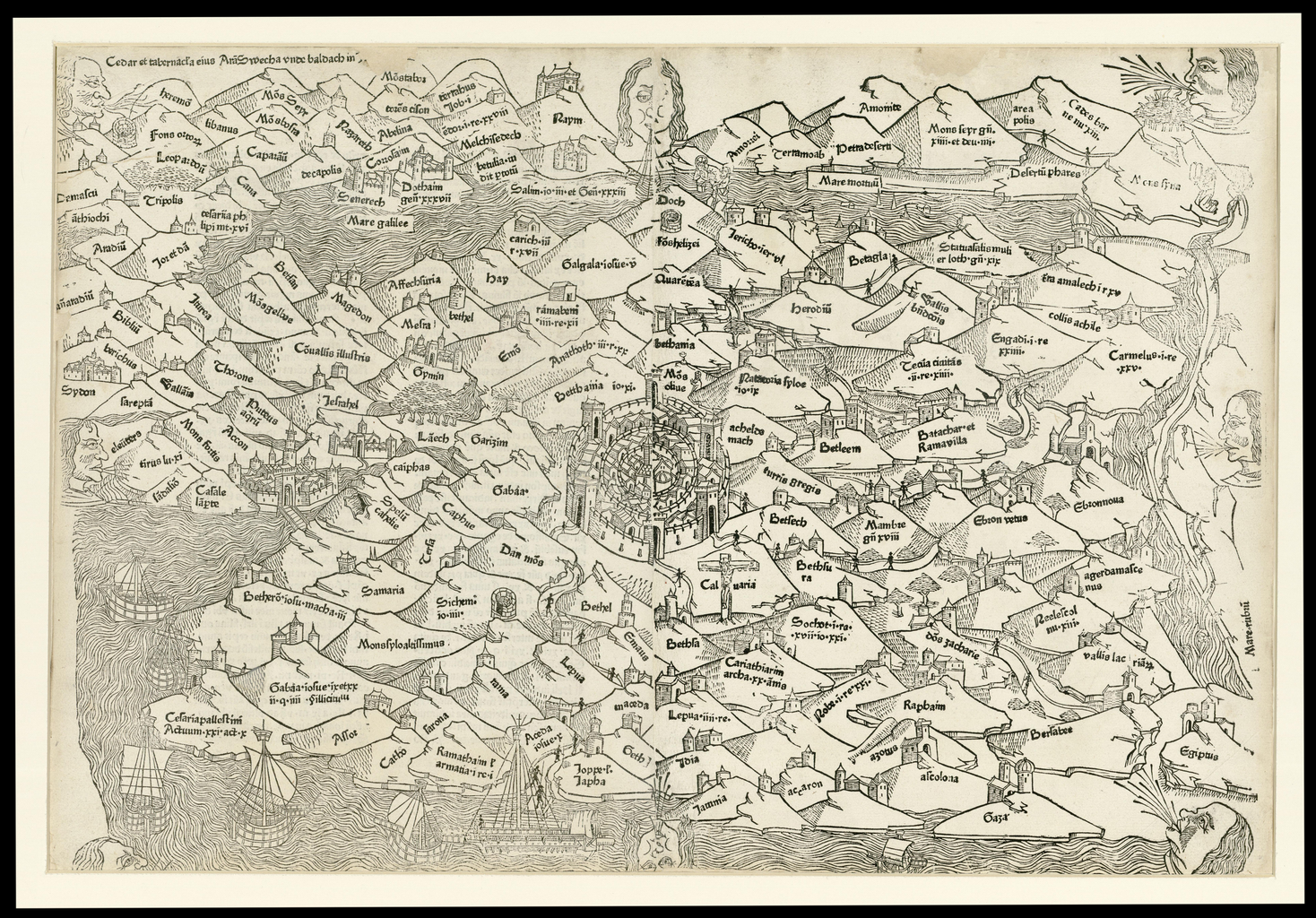
Русский: Эта латинская карта-гравюра Палестины, выполненная на дереве, входит в "Rudimentum Novitiorum" ("Пособие для начинающих") — историю мира, изданную в Любеке (Германия) в 1475 году, в которую включены, как полагают, первые печатные карты. Карта была издана Лукасом Брандисом де Шассом на основе более древней карты Бурхарда де Монте Сиона — доминиканского священника XIII века, много путешествовавшего по Святой Земле и Ближнему Востоку в период с 1274 по 1284 год. Карта ориентирована так, что запад находится внизу. В центре карты находится Иерусалим, что символизирует его ключевое значение для христианского богословия.
Français : Cette carte latine gravée sur bois de la Palestine est tirée du Rudimentum Novitiorum (Un livret pour débutants), qui est une histoire du monde publiée à Lübeck en Allemagne, en 1475 et contient ce qui est considéré comme étant les premières cartes imprimées. La carte fut imprimée par Lucas Brandis de Schass, et se base sur une carte précédente de Burchardus de Monte Sion (Burchard du Mont Zion), un prêtre dominicain du 13ème siècle qui voyagea fréquemment à travers la Terre sainte et le Moyen-Orient en 1274-84. La carte est orientée vers l'ouest dans sa partie inférieure. Jérusalem est située au centre, indiquant sa signification centrale dans la théologie chrétienne.
English: This Latin woodcut map of Palestine is from the Rudimentum Novitiorum (A handbook for beginners), which is a history of the world published in Lübeck, Germany, in 1475 and contains what are considered to be the first printed maps. The map was printed by Lucas Brandis de Schass, and is based on an earlier map by Burchardus de Monte Sion (Burchard of Mount Zion), a 13th-century Dominican priest who traveled extensively through the Holy Land and the Middle East in 1274-84. The map is oriented with west at the bottom. Jerusalem is located at the center, indicating its central significance in Christian theology.
中文:这幅巴勒斯坦的拉丁语木刻地图出自 《Rudimentum Novitiorum》 (初学者手册),这是一本 1475 年在德国吕贝克出版的世界历史,人们认为这本书中的地图是人类最早印刷的地图。 这幅地图是由 Lucas Brandis de Schass 印刷的,根据的是 Burchardus de Monte Sion (Burchard of Mount Zion) 较早前的一幅地图,Burchardus de Monte Sion 是一位 13 世纪的道明会神父,1274-84 年间他曾在圣地和中东进行过广泛的游历。 该地图以下为西。 耶路撒冷位于中心位置,表明该城市在基督教神学中作为核心的重要性。
Português: Este mapa da Palestina, em xilogravura e em latim, é do Rudimentum Novitiorum (Um manual para iniciantes), que é uma história do mundo publicada em Lübeck, na Alemanha, em 1475 e contém mapas que são considerados como os primeiros a serem impressos. O mapa foi impresso por Lucas Brandis de Schass e baseia-se em um antigo mapa de Burchardus de Monte Sion (Burchard de Monte Sião), um padre dominicano do século XIII que viajou extensivamente pela Terra Santa e pelo Oriente Médio, entre 1274-84 . O mapa está orientado com oeste na parte inferior. Jerusalém fica localizada ao centro, indicando a sua importância central na teologia cristã.
العربية: وردت خريطة فلسطين هذه التي نقشت على الخشب في كتاب روديمنتوم نوفيتوريوم (دليل المبتدئين)، وهو تاريخ للعالم نُشر في لوبيك بألمانيا ففي 1475 ويحتوي على ما يُعتبر أول خرائط مطبوعة. طُبعت الخريطة من قبل لوكاس برانديس دي شاس وهي مبنية على خريطة قبلها لبورشاردوس دي مونتي سيون (بورشارد من جبل صهيون)، الذي كان قسا دومينيكيا في القرن الثالث عشر وسافر على نطاق واسع في الأراضي المقدسة والشرق الأوسط في 1274-84. وفي أسفل الخريطة إشارة متوجهة نحو الغرب. وتقع القدس في المركز، دلالة على أهميتها الجوهرية في اللاهوت المسيحي.
Español: Esta xilografía de Palestina en latín es de <l>Rudimentum Novitiorum</l> (Manual para principiantes), que es una historia del mundo publicada en Lubeca, Alemania, en 1475 y contiene lo que se consideran son los primeros mapas impresos. El mapa fue impreso por Lucas Brandis de Schass, y se basa en un mapa anterior de Burchardus de Monte Sion (Burchard del monte Sión), un sacerdote dominico del siglo XIII, que viajó extensamente a través de Tierra Santa y el Oriente Medio entre 1274 y 1284. El mapa está orientado con el occidente en la parte inferior. Jerusalén se encuentra en el centro, lo que indica su importancia en la teología cristiana. |
| Date | 1475 |
| Medium |
Русский: Карты
Français : Cartes
English: Maps
中文:地图
Português: Mapas
العربية: خرائط
Español: Mapas |
| Dimensions |
English: Woodcut; two joined sheets; 388 x 578 millimeters |
| Collection |
Русский: Национальная библиотека Израиля
Français : Bibliothèque nationale d’Israël
English: National Library of Israel
中文:以色列国家图书馆
Português: Biblioteca Nacional de Israel
العربية: مكتبة إسرائيل الوطنية
Español: Biblioteca Nacional de Israel |
| Place of creation |
Русский: Израиль
Français : Israël
English: Israel
中文:以色列
Português: Israel
العربية: إسرائيل
Español: Israel |
| References | http://hdl.loc.gov/loc.wdl/isjjnl.2893 |
| Source/Photographer |
|
Licensing
[edit]
|
This is a faithful photographic reproduction of a two-dimensional, public domain work of art. The work of art itself is in the public domain for the following reason:
The official position taken by the Wikimedia Foundation is that "faithful reproductions of two-dimensional public domain works of art are public domain".
This photographic reproduction is therefore also considered to be in the public domain in the United States. In other jurisdictions, re-use of this content may be restricted; see Reuse of PD-Art photographs for details. | ||||
File history
Click on a date/time to view the file as it appeared at that time.
| Date/Time | Thumbnail | Dimensions | User | Comment | |
|---|---|---|---|---|---|
| current | 12:56, 11 March 2014 | | 1,468 × 1,024 (2.99 MB) | Fæ (talk | contribs) | =={{int:filedesc}}== {{Artwork |artist = |author ={{ru|1=Брандис де Шасс, Лукас}} {{fr|1=Brandis de Schass, Lucas}} {{en|1=Brandis de Schass, Lucas}} {{zh|1=Burchardus de Monte Sion (13 世纪)}} {{pt|1=Brandis de Schass, Lucas}} {{ar... |
You cannot overwrite this file.
File usage on Commons
The following page uses this file: