File:Palais des rois Bell - Douala.jpg
Original file (4,000 × 2,667 pixels, file size: 4.38 MB, MIME type: image/jpeg)
Captions
Summary
[edit]DescriptionPalais des rois Bell - Douala.jpg |
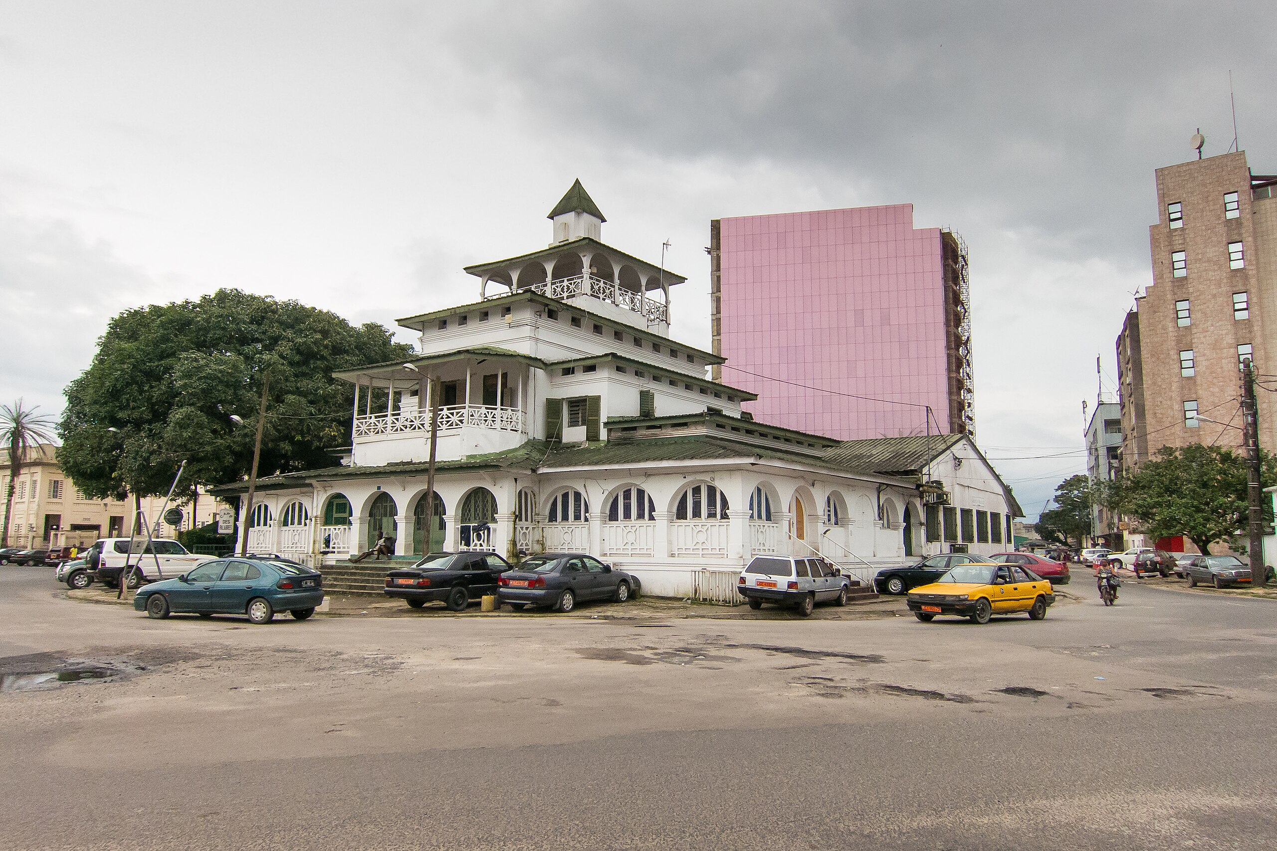
English: This residence was built by the Germans in 1905 for King Auguste Manga Ndoumbe (King Bell). It is known informally as "La Pagode" (the Pagoda), a term given to it by the French writer Louis-Ferdinand Celine who lived in Douala from 1916 to 1917.
|
||
Date | |||
Source | Own work | ||
Author | FischerFotos |
Camera location | 4° 02′ 35.29″ N, 9° 41′ 14.6″ E | View this and other nearby images on: OpenStreetMap | 4.043137; 9.687390 |
---|
Licensing
[edit]- You are free:
- to share – to copy, distribute and transmit the work
- to remix – to adapt the work
- Under the following conditions:
- attribution – You must give appropriate credit, provide a link to the license, and indicate if changes were made. You may do so in any reasonable manner, but not in any way that suggests the licensor endorses you or your use.
- share alike – If you remix, transform, or build upon the material, you must distribute your contributions under the same or compatible license as the original.
This image was uploaded as part of Wiki Loves Monuments 2013.
Afrikaans ∙ Alemannisch ∙ العربية ∙ جازايرية ∙ azərbaycanca ∙ Bikol Central ∙ беларуская ∙ беларуская (тарашкевіца) ∙ български ∙ বাংলা ∙ brezhoneg ∙ bosanski ∙ català ∙ čeština ∙ Cymraeg ∙ dansk ∙ Deutsch ∙ Zazaki ∙ Ελληνικά ∙ English ∙ Esperanto ∙ español ∙ eesti ∙ euskara ∙ فارسی ∙ suomi ∙ français ∙ Frysk ∙ Gaeilge ∙ galego ∙ עברית ∙ हिन्दी ∙ hrvatski ∙ magyar ∙ հայերեն ∙ Bahasa Indonesia ∙ Ido ∙ italiano ∙ 日本語 ∙ ქართული ∙ 한국어 ∙ кыргызча ∙ Lëtzebuergesch ∙ latviešu ∙ Malagasy ∙ македонски ∙ മലയാളം ∙ Bahasa Melayu ∙ Malti ∙ norsk bokmål ∙ नेपाली ∙ Nederlands ∙ norsk nynorsk ∙ norsk ∙ polski ∙ português ∙ português do Brasil ∙ română ∙ русский ∙ sicilianu ∙ davvisámegiella ∙ slovenčina ∙ slovenščina ∙ shqip ∙ српски / srpski ∙ svenska ∙ ไทย ∙ Tagalog ∙ Türkçe ∙ українська ∙ اردو ∙ oʻzbekcha / ўзбекча ∙ Yorùbá ∙ 中文 ∙ 中文(中国大陆) ∙ 中文(简体) ∙ 中文(繁體) ∙ 中文(香港) ∙ 中文(臺灣) ∙ +/− |
File history
Click on a date/time to view the file as it appeared at that time.
Date/Time | Thumbnail | Dimensions | User | Comment | |
---|---|---|---|---|---|
current | 16:44, 29 September 2013 | 4,000 × 2,667 (4.38 MB) | FischerFotos (talk | contribs) | User created page with UploadWizard |
You cannot overwrite this file.
File usage on Commons
There are no pages that use this file.
Metadata
This file contains additional information such as Exif metadata which may have been added by the digital camera, scanner, or software program used to create or digitize it. If the file has been modified from its original state, some details such as the timestamp may not fully reflect those of the original file. The timestamp is only as accurate as the clock in the camera, and it may be completely wrong.
Image title |
|
---|---|
Camera manufacturer | Canon |
Camera model | Canon PowerShot S100 |
Author | Mark Fischer |
Copyright holder |
|
Exposure time | 1/1,250 sec (0.0008) |
F-number | f/4 |
ISO speed rating | 400 |
Date and time of data generation | 15:39, 26 September 2013 |
Lens focal length | 5.2 mm |
Latitude | 4° 2′ 35.29″ N |
Longitude | 9° 41′ 14.6″ E |
Altitude | 29.77 meters above sea level |
Short title |
|
City shown | Douala |
Horizontal resolution | 300 dpi |
Vertical resolution | 300 dpi |
Software used | Adobe Photoshop Lightroom 4.4 (Windows) |
File change date and time | 16:54, 29 September 2013 |
Exif version | 2.3 |
Date and time of digitizing | 15:39, 26 September 2013 |
APEX shutter speed | 10.287712 |
APEX aperture | 4 |
APEX exposure bias | 0 |
Maximum land aperture | 2 APEX (f/2) |
Metering mode | Pattern |
Flash | Flash did not fire, compulsory flash suppression |
Focal plane X resolution | 13,651.877133106 |
Focal plane Y resolution | 13,636.363636364 |
Focal plane resolution unit | inches |
Sensing method | One-chip color area sensor |
File source | Digital still camera |
Custom image processing | Normal process |
Exposure mode | Auto exposure |
White balance | Auto white balance |
Digital zoom ratio | 1 |
Scene capture type | Standard |
GPS time (atomic clock) | 14:39:26.775 |
Receiver status | Measurement in progress |
Geodetic survey data used | WGS-84 |
GPS date | 26 September 2013 |
GPS tag version | 0.0.3.2 |
Lens used | 5.2-26.0 mm |
Rating (out of 5) | 3 |
Date metadata was last modified | 17:54, 29 September 2013 |
Unique ID of original document | 5097CCC75FDD7B5ADD912EF4D93893B1 |
Copyright status | Copyrighted |
Keywords |
|
Contact information | mark@fischerfotos.com
fischerfotos.com
|
Province or state shown | Littoral |
Country shown | Cameroon |
Sublocation of city shown | Bonanjo |
IIM version | 4 |
Structured data
Items portrayed in this file
depicts
26 September 2013
4°2'35.29201"N, 9°41'14.60400"E
0.0008 second
5.2 millimetre
400
image/jpeg
4,593,382 byte
2,667 pixel
4,000 pixel
29d4ed5599827ec3e803b6f01a23a07895f9e987
- Cultural heritage monuments in Cameroon with known IDs
- Files with coordinates missing SDC location of creation
- CC-BY-SA-3.0
- Self-published work
- Images from Wiki Loves Monuments 2013
- Images from Wiki Loves Monuments 2013 in Cameroon
- Images from Wiki Loves Monuments missing SDC depicts
- Images from Wiki Loves Monuments missing SDC location of creation
- Uploaded via Campaign:wlm-cm
- Mark Fischer
- Photographs by Mark Fischer/FischerFotos