File:Painted Hills Unit map.png
Jump to navigation
Jump to search
No higher resolution available.
Painted_Hills_Unit_map.png (490 × 200 pixels, file size: 83 KB, MIME type: image/png)
Captions
Captions
Add a one-line explanation of what this file represents
| Description |
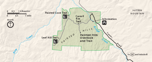
English: Map of the Painted Hills Unit of the John Day Fossil Beds National Monument in north-central Oregon, United States. |
|||
| Date | ||||
| Source | Harpers Ferry Center | |||
| Author | National Park Service; converted from PDF to PNG format by User:Finetooth using GNU Image Manipulation Program (GIMP) software | |||
| Permission (Reusing this file) |
|
File history
Click on a date/time to view the file as it appeared at that time.
| Date/Time | Thumbnail | Dimensions | User | Comment | |
|---|---|---|---|---|---|
| current | 20:29, 12 August 2011 | 490 × 200 (83 KB) | Finetooth (talk | contribs) | {{Information |Description ={{en|1=Map of the Painted Hills Unit of the John Day Fossil Beds National Monument in north-central Oregon, United States.}} |Source =[http://hfc.nps.gov/ |
You cannot overwrite this file.
File usage on Commons
There are no pages that use this file.
File usage on other wikis
The following other wikis use this file:
- Usage on en.wikipedia.org