File:Padstow- a ferryboat is in dock (geograph 4301899).jpg
Jump to navigation
Jump to search
No higher resolution available.
Padstow-_a_ferryboat_is_in_dock_(geograph_4301899).jpg (640 × 480 pixels, file size: 67 KB, MIME type: image/jpeg)
Captions
Captions
Add a one-line explanation of what this file represents
Summary
[edit].jpg&action=edit§ion=1)
| Description |
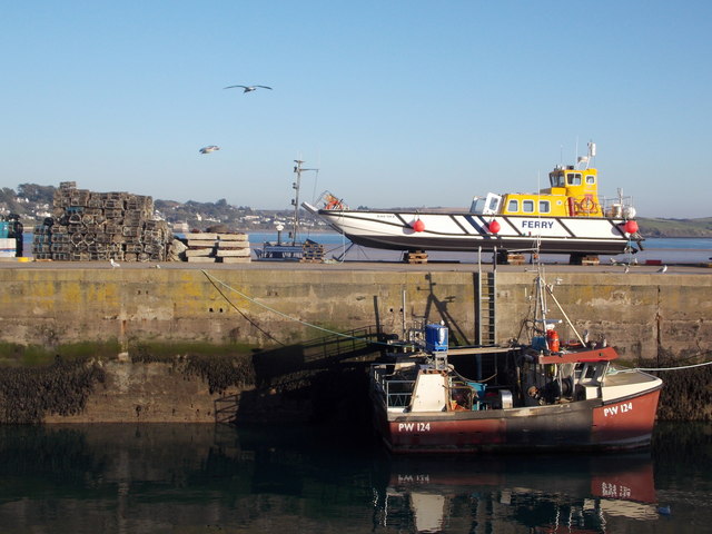
English: Padstow: a ferryboat is in dock. Looking across the southern arm of the outer dock. One of the ferryboats which does the Rock passenger route is being serviced on top of the retaining dock pier. Beyond it, we glimpse the Camel estuary. |
| Date | Taken on 29 December 2014 |
| Source | From geograph.org.uk |
| Author | Chris Downer |
| Permission (Reusing this file) |
Creative Commons Attribution Share-alike license 2.0 |
| Attribution (required by the license) | Chris Downer / Padstow: a ferryboat is in dock / |
| Camera location | | View this and other nearby images on: OpenStreetMap |
|---|
.jpg¶ms=050.540044_N_-004.936275_E_globe:Earth_type:camera_source:geograph-osgb36(SW92047526)_heading:90.00&language=en)
| Object location | | View this and other nearby images on: OpenStreetMap |
|---|
.jpg¶ms=050.540060_N_-004.935710_E_globe:Earth_class:object_type:object_source:geograph-osgb36(SW92087526)_heading:90.00&language=en)
Licensing
[edit].jpg&action=edit§ion=2)

|
This image was taken from the Geograph project collection. See this photograph's page on the Geograph website for the photographer's contact details. The copyright on this image is owned by Chris Downer and is licensed for reuse under the Creative Commons Attribution-ShareAlike 2.0 license.
|
This file is licensed under the Creative Commons Attribution-Share Alike 2.0 Generic license.
Attribution: Chris Downer
- You are free:
- to share – to copy, distribute and transmit the work
- to remix – to adapt the work
- Under the following conditions:
- attribution – You must give appropriate credit, provide a link to the license, and indicate if changes were made. You may do so in any reasonable manner, but not in any way that suggests the licensor endorses you or your use.
- share alike – If you remix, transform, or build upon the material, you must distribute your contributions under the same or compatible license as the original.
File history
Click on a date/time to view the file as it appeared at that time.
| Date/Time | Thumbnail | Dimensions | User | Comment | |
|---|---|---|---|---|---|
| current | 12:12, 15 February 2019 | | 640 × 480 (67 KB) | Chris j wood (talk | contribs) | Transferred from geograph.co.uk using [https://tools.wmflabs.org/geograph2commons/ geograph2commons] |
You cannot overwrite this file.
File usage on Commons
The following page uses this file:
.jpg&oldid=546643484)